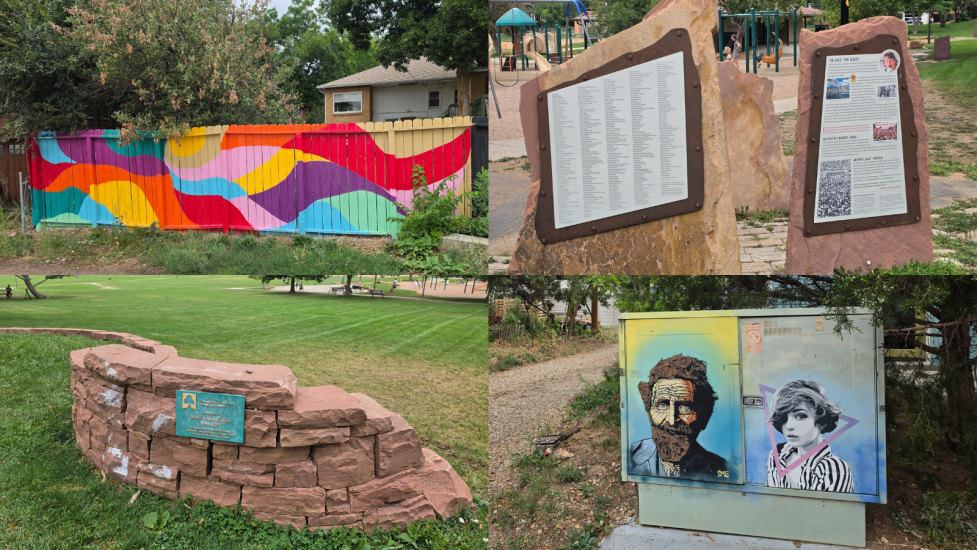
North Boulder Park collage of mural fence, plaques and artwork

A walk to remember

Autumn is coming to Newlands with its glory. Bring the family to our ice cream walk to welcome the change of season. With its maple and cottonwood trees, sprawling lawn, and views of the Flatirons and other Boulder mountains, North Boulder Park is one of Boulder's loveliest: a year-round favorite for outdoor activities, picnics and relaxation.

decorative graphic

Sept. 26 Guided Walk Tour Information

Join us for this free Boulder Walks event as we tour the park and its Newlands neighborhood. After exploring what the park offers and its cultural and sports-centered history, we'll walk the perimeter of the new City of Boulder office campus. Going and coming from our sweet destination, we'll see one of Newlands original homes and visit some Boulder transportation history: concrete engravings along Broadway of sidewalk poetry. Then we'll head to Sweet Cow Ice Cream for a treat, free for kids 18 and under!

Spots are limited. Sign up on GivePulse:

Register for the Sept. 26 guided walk tour

decorative graphic

Event Details

  • When: Saturday, Sept. 26, 2026
  • Walk: 10 a.m. to noon MST. The walk tour will begin at 10:05 a.m.
  • Meeting location: View Google Maps meeting coordinates.
  • Schedule and Planning: Meet on the west side of the park shelter near the parking lot. The starting point is accessible by bus, bike, walking or driving. Parking is free. BCycle station is in the Community Plaza parking lot. RTD SKIP route stops on Broadway between Alpine and Balsam avenues.
  • Sweet Cow Ice Cream: Community Plaza Shopping Center. Ice cream is included for those 18 and under, sponsored by the City of Boulder.

Notes:

  • Walk tour will depart rain or shine. Dress for the weather and bring a water bottle, sunscreen, and an optional camera.
  • All ages welcome!
  • Well-behaved dogs are welcome on 6' or shorter leashes.
  • Restrooms are available at the shelter and Sweet Cow.

General Walk Details

  • PACE: Conversational (1 mile per hour)
  • TERRAIN: Sidewalks, paved multi-use paths
  • DISTANCE: 1.3 miles
  • ELEVATION GAIN: 33’
  • ACCESSIBILITY: The route is stroller- and wheelchair-friendly.

Map

Use the map with the following turn-by-turn directions.

Turn-by-Turn Directions & Self-Guided Tour Information

Overview

Whether or not you attend the guided tour, use the information below at each route marker to enrich the tour. The map link provides directions.

The Autumn Stroll and Scoop guided Boulder Walks tour winds through North Boulder Park before moving south along 9th Street to navigate around the City of Boulder’s new City Hall. Go east on Alpine Avenue to Broadway, noting the map route markers. Go south one block and cross North Street into Community Plaza Shopping Center. After a surely satisfying visit to Sweet Cow, return to the park by going north along Broadway and west on Balsam Avenue.

This area is west of Old North Boulder and only a few blocks from downtown on the north side of Mapleton Hill. It’s known as Newlands, an historic Boulder neighborhood named after William and Mary Newland, who purchased 240 acres in 1871 for a fruit orchard and agriculture. William died tragically in 1886, and Mary went on to manage the farm and subdivide the property into the “Newland Addition.” Apple trees are still on some older lots west of the park. For more information, see the University of Colorado Museum of Natural History article, The Newland family.

Finally, let’s get started!

Route marker A – North Boulder Park – Starting Point

  1. Beginning near the restrooms, west of the shelter at 800 Dellwood Avenue, walk north to where the parking lot meets Dellwood Avenue.

    Notice the unique SMiLE art at the end of the alley across the street, an Italian man. SMiLE is a Colorado stencil street artist.

  2. Walk south in the alley past the parking lot to see the house on the right with the river-of-colors rear fence.

    The park provides the space and equipment for a variety of sports, including cross-country skiing following a good snow, and honors Boulder’s place in history for bike racing and running classics. Sports and exercise areas, many from the park’s 2013 upgrade, include baseball fields, a basketball court, fitness equipment, slacklining, a ping-pong table, running paths, and a kids’ bicycle dirt track.

  3. Head towards the pavilion, noting the ballfields on the right and other sports facilities.

    Another SMiLE, the female gibbon, is peeking around a door under the pavilion.

Coming changes

During October 2026, renovation of North Boulder Park begins with the pavilion and restrooms. Thanks to community involvement, the park’s historic charm is being preserved. All mature trees and shaded picnic areas will remain as is.

Future phases:

  • Modernized playground with distinct, inclusive, accessible zones for two age groups and new nature-play activities.
  • Dedicated teen space with a new fitness court and multiuse flex lawn facing the scenic Flatirons.
  • Historic pavilion refurbished structurally with a new roof, ceiling, and partitions.
  • Stormwater and drainage integration to manage high-water drainage.

  1. Continue to the water fountain. Notice the mountain view.

    North Boulder Park rests in the Dakota Ridge foothills, with views of Mount Sanitas just to the west. Looking southwest, most of Boulder’s mountain parks are visible: Flagstaff, Green Mountain, the Flatirons, and Bear Peak. Maple and cottonwood trees shade the northern area.

    In May 1976, Joe Walsh of The Eagles dedicated this memorial fountain to his daughter, Emma Walsh. With Stefany, her mom, they moved to Newlands from Nederland in the early 70s. Emma died in a car accident just before her third birthday. Joe Walsh and Stevie Nicks wrote songs about her.

  2. Walk north to the monument.

Route marker B – Coors Classic monument and original Bolder Boulder

The park has been an historic anchor for local sports and recreation. North Boulder Park hosted the finish and other stages of international cycling competitions like the Coors International Bicycle Classic and Red Zinger Classic. The 2019 monument commemorates the famous bike races from 1975 to 1988.

This was also the starting line for the inaugural Bolder Boulder 10K race in 1979, now a world-famous event that draws 50,000 people.

Alongside is a tot track for little cyclists with a smooth dirt track, small rolling hills, and a wooden bridge.

Under the cottonwood and maple trees, walk east through the grass to a gathering place in memory of Mary Louise Culkin, an educator who created community programming and safe environments for children and families.

  1. Walk on the path towards 9th Street. Stop at the bench on 9th Street across from Balsam Avenue.

    North Boulder Park was created in the 1920s as the city expanded when parcels of the Newland farmland were sold. Farmers Ditch flowed under this spot and flooded the park until the ditch was reconstructed in the early 1950s.

Route marker C – New City Hall

  1. Head south on 9th Street to Alpine Avenue, continuing to the south side.
  2. On the south side of Alpine, cross 9th Street and move toward Broadway.

    Between Alpine Avenue and Balsam Avenue in this block west of Broadway, the City of Boulder is building a centralized new campus for department offices and services called City Hall. Two existing buildings are being renovated, and the parking garage is being reused.

    The design of City Hall reflects the community's desire for a more sustainable and pedestrian-friendly environment. Through an extensive area planning process, it became clear that promoting alternative modes of transportation was a priority. As a result, the campus will prioritize expanded walking and biking paths and minimize parking to encourage more environmentally friendly modes of transportation.

    The grand opening of City Hall is planned for 2027!

Route marker D – Boulder transportation history

  1. Cross Alpine Avenue, if necessary, staying on the west sidewalk on Broadway.
  2. Walk south to North Street.

    Find the paw prints in concrete and sidewalk poetry messages:

    • "Speed limit ten miles per hour in business district." Daily Camera, 1909.
    • "Out to the north the [streetcars] now run" Boulder Daily Camera Headline, 1912.
    • 1940: Driving to Ideal Market for groceries begins.
    • Tracks in the sidewalk for an old streetcar, Boulder Street Railway (1903 to late 1920s).

    At North Street and Broadway, note the funny British restaurant named after a frog, the Hungry Toad. The coat hangers on every booth are golden frogs.

  3. Carefully cross at the Broadway traffic light.

    Find the Boulder transportation history in the pavement and on the bus shelter.

    The Chapman House, one of the historic Newlands homes, is across the street at 2517 Broadway. It was a guest house during the founding years. It’s on the southern edge of the neighborhood area and is a well-preserved example of Boulder's early vernacular residential architecture.

  4. Cross North Street into the Community Plaza Shopping Center.

Route marker E – Sweet Cow

Use the sidewalk around the parking lot to the shops and then to Sweet Cow Ice Cream at 2628 Broadway. Enjoy! During the guided walk, ice cream for kids is free.

Route marker F – Return to the park pavilion

  1. Leaving Community Plaza Shopping Center, head north on Broadway.

    Look for more transportation sidewalk poetry near the bus stop in front of Boulder Medical Center.

  2. At Balsam Avenue, cross Broadway to the north sidewalk on Balsam Avenue.

    Just to the north, at 3011 Broadway, is The Newland House, built by Mary in 1889. It’s a Queen Anne mansion, a Boulder landmark. Notice, when returning to the park, the Craftsman bungalows, Tudor Revivals, and early-century cottages that surround the park.

    Note the City campus landscaping and park. On this north side of Balsam, the campus is a greenway for flood mitigation in a parklike setting.

  3. Cross 9th Street and enter the park. Return to the North Boulder Park pavilion.