Project Overview
Better bikeway wayfinding signage will help our community and visitors find comfortable, lower-stress routes to travel on and encourage more people to explore the city by biking, rolling and walking.
The City of Boulder is updating its bikeway and destination wayfinding to make it easier for people biking, rolling and walking to navigate in and across town.
You can review and provide feedback on the sign design options and elements. Based on community feedback, we will refine designs throughout summer 2026.
Better bikeway wayfinding signage will help our community and visitors find comfortable, lower-stress routes to travel on and encourage more people to explore the city by biking, rolling and walking.
Boulder has designated comfortable, lower-stress bike routes around town that connect key destinations. To help people easily find these routes, we're proposing using route names and numbers on wayfinding signs, similar to highways.
People could follow these low-stress routes by their name or number.
We would post bike symbols on existing signage for all other bike routes in the city, including high-stress routes and smaller neighborhood connections.
Watch the video below to see a simulated bike ride featuring the proposed signs in North Boulder.
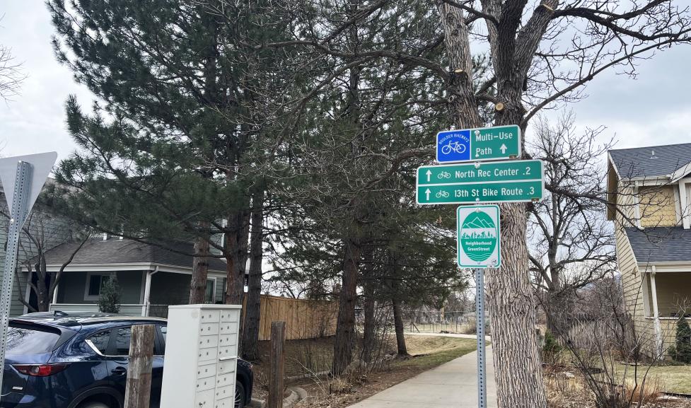
The first image shows an example of new signage. The other images show examples of current signage.
Currently, we use green and blue Boulder bikeway signs.
Green signs show destinations.
Blue signs label turns, distance to other bike routes and key destinations like parks and schools, and bike facility types, which include: on-street bike routes, which are shared lanes with vehicles, on- and off-street bike lanes, and off-street multi-use paths.

1 of 3

2 of 3

3 of 3
Current bikeway signage is sometimes confusing, incomplete, and inconsistent, making it harder for travelers to reach their destinations.
For example:
While there will be a new family of signs that designates named and numbered routes along the spines of the network, the proposed wayfinding approach also aims to:
The Lower-Stress Crosstown Bikeway includes north-south and east-west routes across Boulder. These routes are highlighted yellow on the city’s bike map.
Standard blue and green colors and bike symbols follow national standards for roadway signage. Our Transportation & Mobility Department can also make and maintain these signs, which reduces costs.
Bikeway and destination signage is most commonly placed at intersections: decision-points for people to continue on their current route or turn to a different route or destination. We usually install signage on existing signposts, with signs for multiple directions placed on the same signpost to limit the number of signposts needed and minimize installation and maintenance costs.


