Boulder’s Historic Movers and Shakers – And Their Haunts

Wind through west Boulder’s colorful characters and their places, including People’s Crossing, Eben G Fine, Mattie Dean Garden, Columbia Cemetery, Hannah Barker House, Arnett-Fullen House.

Walk the self-guided tour anyime or tour with one of our Walk Leaders on Oct. 26!

Bring the family to experience the magic and myth of the West Pearl Historic District. Comprised of twenty-five buildings from 3rd Street to 6th Street and south to Boulder Canyon Drive, unique architecture, landmarks and changing fall colors make this neighborhood a fascinating walk through history.

Walk the paths of Boulder’s historical figures up to the resting place of many of them. While this venture is outside most of the Pearl Street business district, learn how the late 19th century flood altered the history and architecture of west Pearl Street. Along the way, regardless of the time of year, consider the landscaping splendor of some of the loveliest yards in Boulder.

As the route leaves downtown and heads up Pearl Street towards Red Rocks and The People’s Crossing, the footpath becomes one taken over time to access the canyon, water and mountains. Experience history while passing by the Indigenous People’s trailhead over Boulder Creek into Eben G. Fine Park. Wind around Flagstaff Mountain to University Hill. Pass through early pharmacologist and naturalist Mattie Dean Garden into Columbia Cemetery, the eventual communal ground of many who developed West Pearl and this town. Close the loop by returning along 9th Street, locating other landmarks, including the Progressive Era philanthropist Hannah Barker’s house and Historic Registry Arnette-Fullen House.
  • TIME: 9-11 a.m.
  • PACE: Conversational (2-3 miles per hour)
  • TERRAIN: Sidewalks, paved multi-use paths
  • DISTANCE: 3.3 miles
  • ELEVATION GAIN: 170’ (delta 110’); mostly flat
  • Bike, BCycle, walk, drive, or take the Hop or Skip RTD bus route for a multi-neighborhood walk alongside and through historic west Boulder landmarks.
  • The route is stroller-friendly and appropriate for powered wheelchairs and ambulatory walkers. Overall elevation gain is 110 feet. See contours on map.
  • There are restrooms at the starting point and in Eben G. Fine Park, one mile into the walk.

Area 1: West Pearl Historic District

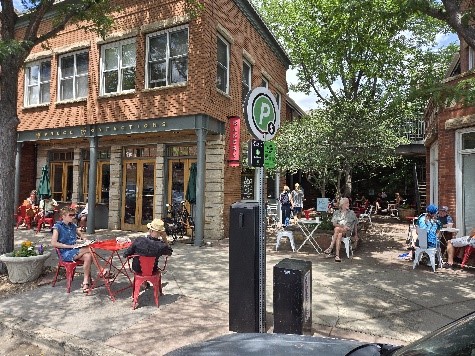
  • Begin at Spruce Confections at 767 Pearl Street and head west, remaining on the north sidewalk.

Outside of Spruce Confections. People sit in chairs outside the cafe and talk and eat.
Outside Spruce Confections

Boulder was a supply center for mountain gold mining and Pearl Street was supposedly named after the wife of one of the mining founders. Madam Pearl, who ran a brothel nearby, is another theory behind the name.

The area was a hunting ground for the Arapaho tribe before Pearl Street was developed in the 1860s. At Broadway and Pearl, a surveyor sighted Valmont Butte beyond what is now 55th Street, and downtown was built along that line. Supply and hardware stores lined east Pearl, while industrial smelters and tungsten mills were in the westerly direction.

The railroad from the mountain mining towns carried ore and metals into Boulder. In 1894, a rapid, massive snow melt became flood waters that swept away mining towns, all bridges, and houses in east Boulder. Neighborhoods were destroyed, including where the Boulder County Justice Center and Penfield Tate II Municipal Building are now located on Boulder Canyon Drive, then Water Street. Industry in west Boulder was spared and continued to prosper.

West Pearl Historic District comprises twenty-five buildings from 3rd Street to 6th Street and south to Boulder Canyon Drive, including Walnut Street – known then as Front Street. The first houses were modest vernacular architecture.

  • Walking west on Pearl Street, note the unique architecture of the homes and houses occupied by art galleries, agencies, and other businesses.
  1. 741 Pearl Street, alongside the driveway next to Spruce Confections, is the Montgomery House, an historic Queen Anne built in the 1870s by Anthony Arnett. Currently home to a nonprofit art collective, The New Local, Benjamin Franklin "Frank" Montgomery bought the house in 1896. He was from Virginia, came to Boulder County in 1863 from Iowa, and initially farmed on the St. Vrain River near Lyons. Montgomery married Louisa Hall, a pioneer from Ward, in 1879 and they had six children.
  2. 709 Pearl Street, four houses down, is a two-story brick storefront representative of an early Boulder establishment built prior to 1895. It was a meat store and then a grocery store with various owners through 1913. The building has a raised foundation, and the façade is symmetrical with large display windows and transoms. The rear and second floor were residential.
  3. 508 Pearl Street in 1876 was the first area home, built by Jacob and Bernadina Drumm from Germany.
  4. 406 Pearl Street is a Queen Anne cottage, built by Lon and Mary Maxwell in 1903.
  5. 207 Pearl Street, located near the beginning of the street beneath Red Rocks, is half stone and half wood. It was built by John Brierley in 1871, who came to Colorado in 1858. He raised cattle and planted apple, pear and peach trees north and east of his home. Brierley also planted a large vegetable garden and fruit-bearing bushes.

Along Pearl Street, depending on the time of year, you may be greeted with lovely flowers - irises, poppies, columbine, and asters at the sidewalk’s edge, all native to Boulder.

To the southwest, gaze beyond the houses and note the comforting, continuous upward slope of Flagstaff Mountain presenting its verdant overlay or golden autumn hue.

Area 2: The Peoples’ Crossing, Eben G. Fine Park 

  • Approaching the top of Pearl Street, before it merges with Boulder Canyon Drive, stay to the right on the path and head up into Peoples' Crossing.

The stream that you immediately cross over is Farmer’s Ditch, which begins just feet ahead in Eben G. Fine Park at Boulder Creek, and continues through Mapleton, Old North Boulder, agricultural land beyond Jay Road, and Boulder Valley Ranch. Farmer’s Ditch empties in Boulder Reservoir and, since its creation in the 1860s, has provided vital irrigation for crops over 3,000 acres.

Off-route option

A shaded respite above Farmer’s Ditch is nearby in Campbell Robertson Park, where you have just passed. One short block off Pearl Street at 5th Street, walk the short distance to Spruce. A pastoral setting with benches and flowerbeds awaits in the small pocket park. The steps from 5th Street can be avoided by using the path from the first driveway around the corner on Spruce.

  • In The Peoples’ Crossing park, walk a short distance up the path to the network of trails trailhead.

A bridge over Farmer’s Ditch connects the parking lot to the trailhead. Formerly known as Settlers Park, the name has reverted to how the location was identified by Indigenous Peoples. Historically, The People’s Crossing was a crossroads for those who traversed the region, as it is today for those hiking the network of Anemone Loop scenic trails and sandstone Red Rocks formations.

  • Continue down the paved path and walk through the underpass under Boulder Canyon Drive and then over Boulder Creek into Eben G. Fine Park.

Eben G. Fine Park is a popular community park for picnics and sunny Colorado days. The grassy park includes public restrooms, playground, picnic tables, historic stone shelter, Flagstaff hiking trail access, RTD access, and bike route access. Also, Boulder Creek Path passes through the park, alongside Boulder Creek.

Eben Givens Fine was born in Missouri in 1865, came to Boulder in 1886, and took a job in George Fonda's drug store. Fine became a pharmacist and part owner of Temple Drug Company. He retired in 1927 and was elected secretary of the Boulder Chamber of Commerce for many years.

Fine raised support to help build the Boulderado Hotel and the Semi-Centennial Celebration in 1909. He helped bring a group of Ute Indians to Boulder for the event. Referred to as “Mr. Boulder,” Fine spoke extensively about Boulder and led nationwide tours to promote Boulder with slide lectures. Eben G. Fine died in 1957 at the age of 91. His is Lot E-9 in Columbia Cemetery.

Area 3: Lower Arapahoe

  • Leaving Eben G. Fine Park, proceed up the incline onto the north sidewalk of Arapahoe Avenue and head east to the first street.

Look over your right shoulder above the row houses into the luscious slopes of Flagstaff Mountain.

  • Turn right and head up 4th Street, staying on the west sidewalk with its shaded arbor and lovely landscape yards, which continue for a couple blocks.
  • Make the bend on the raised sidewalk and walk east on Marine Street.

The street was named after Marinus "Marine" Smith, an early farmer and gold seeker who was the original landowner of Columbia Cemetery, which you are approaching. His is Lot E-15 directly ahead from the main cemetery entrance on the north path, just before the west path on the left.

  • Turn right on 5th Street and walk up the incline, turning left onto University Avenue.
    Cross over to the sidewalk on the south side of the street.

Zoom in on the map of this route and notice the pattern since entering Eben G. Fine Park. The mountain rises directly behind the houses to the west of each of the streets along the Flagstaff Mountain foothills. With the changes in land use from approaching People’s Crossing, back at the end of Pearl Street, to entering Columbia Cemetery up ahead, you will have remained between the 5400’ and 5440’ contours with a gradual uphill climb. Each of the recent left turns have been tangents on the 5440’ contour curve. Once inside Columbia Cemetery, the grade is steeper with its own 40-foot contour inside its gates (5440’ to 5480’).

Area 4: University Hill

  • Moving east across University Ave, you are now in University Hill.
  • Walk three blocks to 8th Street and turn right.
  • Take an immediate left into University Alley and begin looking on the right for a slightly hidden path into Maddie Dean’s Garden, about halfway down the block.

The city maintains the donated garden with the intention of honoring Maddie’s 1982 request to allow the flora and fauna to thrive as undisturbed as possible. Wind your way through the garden. Rest on the stone bench for a moment and travel back in time.

Maddie Dean moved to Colorado from Oklahoma with her sister in 1913, studied at CU Boulder and became a pharmacologist, and was active in the community until she passed away in 1982.

Area 5: Columbia Cemetery

  • Exit Maddie Dean’s Garden onto Pleasant Street. Turn left and walk east a half block to the main cemetery entrance.

Welcome to Pioneer Gateway Columbia Cemetery.
Here lies many of those who gave Boulder its historic stature.

Two large, gated stone wall sections flank the entrance and crusher fines path, which is the smooth dirt surface throughout the cemetery. It is wheelchair accessible but there is a gradual 40’ grade within the grounds.

Anderson Ditch hugs the Flagstaff foothills and flows through the cemetery. The water supports landscaping and parks and is part of the municipal water supply for the City of Boulder.

  • If interested, just inside the entrance to the left, take a photo of the plot map to cross-reference lots throughout the walk. Follow the accompanying map to cover most of the cemetery’s area – walk west, then south (up the hill), then the southeast corner loop, then north back down to the main entrance.

Columbia Cemetery – also known as Pioneer, Park, Masonic, Old, Boulder, and City cemetery – is officially the second cemetery in Boulder. Ten acres were purchased from Marinus G. (Marine Street) and Anna Smith (Lot E-15) in 1970 and developed by the Masonic Columbian Lodge. The first cemetery was located above the southwest corner of Folsom and Valmont, where Unity Church is located.

Columbia Cemetery had its first burial after Anna Eggleston died in May 1970 (Lot E-3). The cemetery grounds were neglected. Early photos show cattle among the tombstones, herded by cowboys. Trees were planted in the early 1900s. City of Boulder Parks and Recreation assumed the difficult maintenance of Columbia Cemetery in 1966. There remain a few plots and there was a recent burial in the northwest corner, but it’s difficult for equipment to enter the cemetery.

In 1904, the Boulder Cemetery Association created Green Mountain Cemetery east of Chautauqua. Over the years, some plots were removed from Columbia Cemetery and reburied in Green Mountain and other cemeteries.

Notable Residents and Grave Markers 

Graves are listed in counter-clockwise order from the main entrance at 9th Street and Pleasant Street.

  • Edward and Elizabeth Trezise, F-4
    Inside the front gate, along the fence. Edward and Elizabeth were parents of John G. Trezise, the undertaker of Trezise's Undertaking Parlor, where Salt restaurant is located at Pearl and 11th Street.
  • Clara Savory, husband George, son Roy; F-7, three plots west of F-4
    Clara was the first librarian for Boulder Public Library and operated the first reading room in Boulder at Broadway and Spruce, above where the Aristocrat Restaurant used to be. The library opened in 1906, and Clara managed it until retiring in 1915. Her son died of diphtheria at age 10 and her husband the next year in a farming accident.
  • Lewis Cheney and family; F-12, five plots west
    Lewis started the First National Bank in 1877 and was considered one of the most enterprising and wealthy Boulder citizens. The First National Bank was on the southeast corner of Broadway and Pearl Streets until 1918.
  • Charles Dabney, F-17
    Dabney came to Gold Hill in 1860 and Boulder in 1864. His positions included County Commissioner in 1863, Justice of the Peace, and Mayor. He operated a blacksmith shop and was in real estate and the lumber business. He and A J Macky owned the first brick building on the north side of the 1200 block of Pearl Street.
  • Mary Rippon, Lot West Avenue Reserve-1
    Beloved and mysterious early University of Colorado professor.
  • Dorothy Gay Howard, Section B
    Previously unidentified murder victim whose gravestone reads, "Jane Doe, April 1954, age about 20 years." She was recently identified by the Boulder County Sheriff's Office and from Phoenix AZ. Her family has not yet decided if her remains will reside in Columbia Cemetery or be re-interred elsewhere.
  • Sylvanus Wellman, B-45
    Boulder farmer who planted first crops in the area.
  • James B. Viele, B-58
    Early homesteader and farmer who brought the first threshing machine to Boulder County.
  • Captain David Nichols, C-62
    Controversial political figure, participated in Sand Creek Massacre.
  • Dr. Mary T. Lowrey, C-69
    Early Boulder physician and surgeon.
  • Tom Horn Legendary "Old West," C-74
    Stock detective.
  • "Rocky Mountain Joe" Sturtevant, E-37
    Colorful early Boulder photographer and painter.
  • James P. Maxwell, D-8
    Early engineer and builder of first Boulder Canyon road.
  • Marietta Kingsley, D-23 (no marker)
    Boulder's memorable "lady of the evening."
  • War veterans, D-26 and B-50
    Several markers read, "Union Soldier."
  • William "Billy" Martin and George Lytle, D-109 and B-68
    Discoverers of the Caribou Lode that initiated the Colorado silver boom.
  • Paula Barchilon, East Avenue Reserve-2
    The bright red marker for little Paula is one of the most recognized gravestones and has been nicknamed the "Lollipop Stone" by local children.
  • George Fonda, A-12
    Fire chief, hose runner, and drug store merchant.
  • Andrew J. Macky, A-94
    Gold rush settler, Postmaster, founding director of First National Bank, University of Colorado financier, and builder of Boulder's first frame house. Primary figure in Boulder's history until his death in 1907. Macky bequeathed $300,000 to the university for Macky Auditorium.

9th Street & University Avenue flowers

  • Departing the cemetery at the main entrance, walk north down 9th Street to University Avenue.

There are native flowers and plants within the island of the intersection that are praiseworthy.

Area 6: Hannah Barker House

  • Continue walking north on 9th Street to Arapahoe Avenue and turn left, remaining on the same sidewalk on the south side of the street. Walk to the fifth house at 780 Arapahoe Avenue.

Hannah Connel Barker immigrated from Ireland in 1852 and moved to the mining town of Ward where she taught school in the local salon. She moved to Boulder in 1869 as one of the first female teachers and married Ezra Barker in 1877. He died in 1883, and Hannah inherited his real estate holdings, becoming a successful businesswoman. She passed away in 1918.

Hannah was a leader in women’s clubs during the Progressive Era, having established and chaired committees that performed civic projects important for women in Boulder when intellectual pursuits for women were limited.

Barker was a Boulder National Bank director for years and donated lands for Pleasant View School and Boulder Valley Grange #131 in Lafayette. With other women, she cofounded a creamery in the late 1890s.

The house went through numerous renovations and additions during Hannah’s life and on into the late 1990s, when it was in serious disrepair. In the early 2000s, demolition was a threat, but the City of Boulder designated the property a local landmark in 2009. Historic Boulder received the house in 2010 and completed stabilization and rehab work in 2016.

Area 7: Downtown

6th Street & Canyon Boulevard flowers

  • Continue on Arapahoe Avenue to 6th Street.
  • Cross the intersection twice to the northwest corner of 6th Street and walk towards Canyon Boulevard.

Enjoy the landscaping at 6th Street and Canyon Boulevard. Seasonal flowers abound from spring through fall.

  • Carefully cross Canyon Boulevard and then cross 6th Street at the same intersection.
  • Walk east onto the path through Canyon Pointe Park.
  • Continue in the same direction onto the north sidewalk on Walnut Street.

Sherpa’s Adventure Restaurant and Bar

  • Walk one block to Sherpa’s at 825 Walnut Street.

Sherpa's Restaurant opened in 2002 sharing a love for quality Himalayan cuisine and culture. With its passion for the mountains, Sherpa's was a natural match for Boulder. Talented chefs have earned it the best Nepalese/Indian restaurant 2002 thru 2022.

The restaurant features an authentic, charcoal-fired, Tandoor clay oven and Traveler's Library & Lounge, stocked with Sherpa history and pictures, Mt. Everest, and other expeditions, and trekking and volunteer trip opportunities.

The Arnett-Fullen House

  • Return via Walnut Street and turn right on 8th Street.
  • Turn left on Lawry Lane and walk through the alley to 7th Street.
  • Cross to the west sidewalk and walk north towards Pearl Street.

Enjoy an entire block of glorious flowers on the Arnett-Fullen House wrought iron fence. Proceed around to the front of the house for the architecture perspective and historic plaques.

646 Pearl Street is home to the Gingerbread House, also known as the Arnett-Fullen House. Construction finished in 1877, and the house was listed on the National Register of Historic Places in 2009. Built by the Willamette Arnett family and purchased by the Fullen family, the architecture is mixed, ascendant Gothic Revival.

Spruce Confections

  • Carefully cross Pearl Street in front of the Arnett-Fullen House and return to Spruce Confections.

Per Spruce Confections: "Enjoy some of the best pastries and coffee in Boulder. Visit Sunday mornings for live music. Sometimes smooth jazzy. Sometimes bluegrass. Always exactly right."

References

Disclaimer: We recognize that this is an incomplete history and encourage you to do your own research to continue exploring Boulder’s history.