Completion Date
Spring 2023

Project Overview

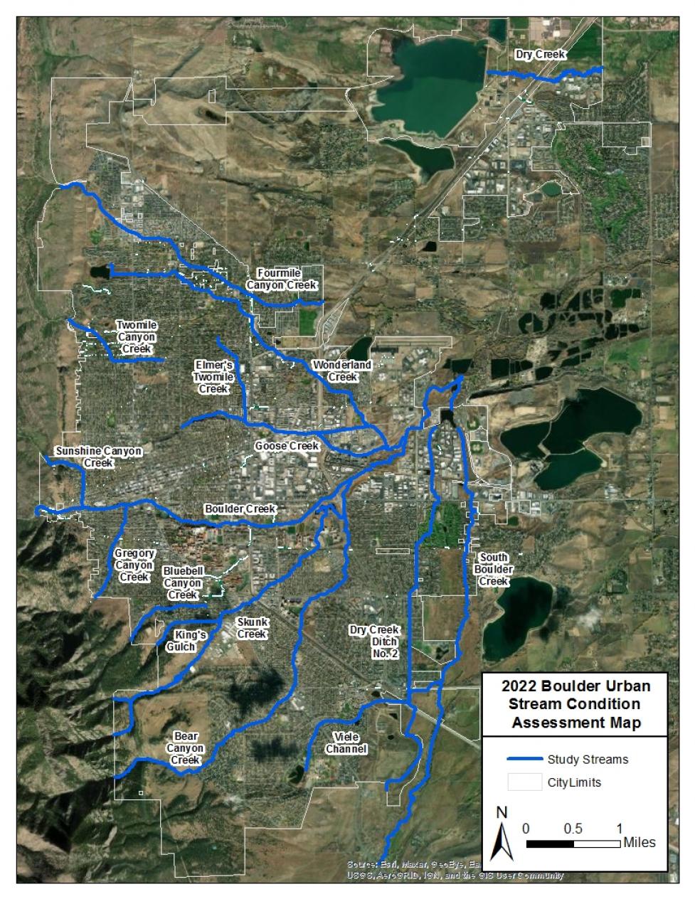
The City of Boulder’s streams and riparian areas are valuable ecological and community resources. Environmental stewardship and responsible development are the guiding principles behind the city’s management of these areas. The City of Boulder’s Utilities Department is partnering with the Mile High Flood District to conduct a stream condition assessment along 47 miles of streams within Boulder (Project Area Map).

The goal of this project is to assess stream and riparian zone (area immediately adjacent to streams) conditions throughout the city. The assessment will be used by the city to prioritize maintenance actions and restoration activities to improve the condition and function of Boulder’s streams and riparian areas.

Project Timeline

The project team will begin the stream assessment in March 2022 with an anticipated completion date in early 2023. Stream walks will be conducted in spring and summer 2022.

Project Area Map

Urban Stream Assessment Project Area Map

This project will evaluate over 47 miles of streams from Boulder’s major drainageways within city limits (Map 1).

Project Background

The primary objective of this project is to assess stream and riparian areas within city limits to determine where improvements can be made through maintenance actions or restoration projects. Conducting a comprehensive condition assessment of the city’s streams and riparian areas will help the city to manage these spaces most effectively and prioritize available funding from the Mile High Flood District.

This project will use the Mile High Flood District’s Urban Stream Assessment Protocol that was created specifically for urban streams and focuses on five elements of stream condition: geomorphology, hydrology, hydraulics, vegetation and community values. Each of these elements will be assessed using a variety of mapping and field-based metrics. This project will also include an asset inventory and condition assessment of stream infrastructure including bridges and culverts, stormwater outfalls and diversion structures.

Mapping will be performed using geographic information systems (GIS) software, while field-based metrics will be assessed during stream walks that will be conducted by our project team. The data collected from the mapping and field-based metrics will be used to improve stream management by identifying and prioritizing maintenance actions and restoration activities along Boulder’s major drainageways. The results from this study will be summarized and made publicly available upon completion of this project.

Project Team

The City of Boulder’s Utilities department is collaborating with the Mile High Flood District, Enginuity Engineering Solutions, Great Ecology, and Watershed Science and Design to complete this assessment.