If the structure or proposed work is in the 100-year floodplain (or the structure is a critical facility located in the 500-year floodplain) a floodplain development permit is required. You can determine if your structure is in the 100-year floodplain using the city’s interactive flood map. Floodplain Development Permits for certain project types, solely within the 100-year floodplain, such as alterations, MEP’s, renovations/remodels, new builds, and additions have now been combined into a single review process completed under a Building Permit Application. If any portion of the structure lies within the floodplain, then the entire structure is subject to the Boulder Revised Code floodplain regulations.
How to Use this Guidance Document
Each section of this guidance document corresponds with each section of the Floodplain Development Permit Application. This guidance document was prepared as an educational tool to help explain portions of the floodplain regulations as they pertain to development in the floodplains. It is not intended as a complete or detailed explanation of the legal requirements that may apply to a particular property. Title 9, Chapter 3 of the Boulder Revised Code is the controlling legal document.
Common Questions
Floodplain Development Permits for fences have been combined into a single review process completed under the Fence Permit Application. Proper design is required for fences within the High Hazard Zones and Conveyance Zones to not obstruct the flows of floodwaters. Fences and fence posts within the floodplain shall be constructed of flood-damage resistant materials and be sufficiently anchored to withstand floodwater forces.
Standalone floodplain development permit applications are required for projects that exceed the typical scope of review for activities described above. Standalone permits will require a separate application submittal for staff review, reach out to staff if you have any questions about floodplain requirements related to your project. Some examples of standalone permits include flood map revisions, projects requiring an emergency management plan, site grading over six inches, site work that requires a hydraulic analysis, projects that require dry-floodproofing certification, bridge replacement, wetland projects outside of the defined maintenance activities, or any type of development occurring within the High Hazard or Conveyance Zones.
Most projects do not require an engineer. However, if your project is in the Conveyance or High Hazard Zones, or an emergency management plan is required, your project may need a licensed engineer. You can determine if your structure is located in the Conveyance or High Hazard Zone using the city’s interactive flood map. If your project requires an elevation certificate or a determination of flood elevations, your project may need a licensed engineer or surveyor.
Please see the Summary of Development Regulations section of this document. It is helpful to understand what flood zone your structure is currently within and what project type your scope of work falls under. Exemptions to floodplain development permits are listed in Section 9-3-6(a), B.R.C. 1981.
Standard building and fence permits require three weeks for floodplain development reviews. Review times can take longer for standalone floodplain development permit applications.
Applications are submitted via the Customer Self Service (CSS) online portal. Additional information on the permit submittal process can be found on the city’s Permit Application Guide. Application must include:
- A complete Floodplain Development Permit Application.
- Owner’s Signature.
- Any other required application materials in PDF format.
Owner’s Signature
The written consent of the owner(s) of all property subject to the development request must be provided. The owner(s) of the property must sign the application form or it will not be accepted. Attach additional signature sheets as necessary. A signature from the owner’s representative is not permissible.
If the project is on City property or is a City project, please have the City representative managing the project sign the document as the owner.
Project Type, Permit Review and Cost Table
Standalone permits require a separate floodplain development permit application submittal through the CSS portal. Provide a completedFloodplain Development Permit Application with all types of permits.
| Project Type | Application Cost |
|
|---|---|---|
| $3,675 |
|
| $3,600 |
|
| $1,400 |
|
|
$700 |
|
| $350 |
|
| $85 |
|
| $35 |
|
Resubmittal fee is 25% of original permit application cost may apply. | ||
Project Details
Project Type
Identifying the correct project type is critical to determine which flood regulations apply.
| New Structure | new primary or accessory structure such as a new homeor detached garage |
|---|---|
| Addition | addition of floorarea including exterior floor area such as a mud room,porch or deck |
| Alteration | change in the structural, mechanical or electrical layout of the structure such as the construction of a new dwelling unit within an existing structure or adding a bathroom |
| MEP* Improvement | construction of new electrical, mechanical or plumbing components such as new solar panels, electrical outlets or hot water heaters |
| Remodel/Renovation | work performed within or to an existing structure that does not fundamentally alterits use such as a kitchen remodel or new floor layout |
| Fence | any fence, barrier, retaining wall or upright structure such as a security or privacyfence |
| Other | other projects notlisted such as a changein watercourse, grading, or site work |
*MEP stands for Mechanical/Electrical/Plumbing
Building Type
Building type helps staff identify permit history and record keeping associated with that structure
| Principal | main or primary structure on the lot |
|---|---|
| Accessory | detached building or structure locatedupon the samelot as the principal building or structure to which it is related |
Existing and Proposed Use
If the structure is changing use, the structure must be brought into compliance with all floodplain regulations for the new use.
| Residential | any structure that is the temporary or permanent domicile of persons for periods of six months or more |
|---|---|
| Non-Residential | any structure that is usedexclusively for office,commercial, industrial, or governmental occupation, or the temporary lodging of persons for periods of less than six months. |
| Mixed-Use | any structure with both residential uses and nonresidential uses where no less than25% of the finished floor area contains nonresidential uses |
| Vacant Land | areas voidof any structures |
Critical and Lodging Facilities
New Critical Facilities and Lodging Facilities must be elevated two feet above the base flood elevation. New or Existing Critical or Lodging Facilities are required to submit an Emergency Management Plan before building permits may be issued. You can utilize the city’s interactive flood map to determine if your structure is a critical or lodging facility.
| Critical Facilities | emergency medical facilities, hazardous materials facility, preschool, primary school or secondary school, daycare, residential care or congregate care facilities |
|---|---|
| Lodging Facilities | hotels, motel,dormitory, bed and breakfast, hostel, emergency shelter and overnight shelter facilities |
Flood Zones
If any portion of the structure (including roof overhang, gutters, footings, decks, balconies, etc.) encroach into the 100-year floodplain or conveyance zone then the entire structure is in the 100-year floodplain or conveyance zone, respectively. Unconditioned, unenclosed building elements such as balconies, awnings, and roof overhangs may extend up to four feet into the high hazard zone if completely located above the flood protection elevation.
The city’s interactive flood map can be used to obtain creek names and flood zones.
- Click on the “Map of Floodplains (interactive)” link to open the interactive flood map.
- Click on the search icon in the top left-hand corner and type in the project address and hit enter.
- Click on the structure or proposed project location. The surrounding floodplain that impacts the property will be highlighted with a light blue line and an informational pop-up window will open that will look like this image below. If the “FEMA Flood Zones” panel does not open, then the property is not located within an identified floodplain.
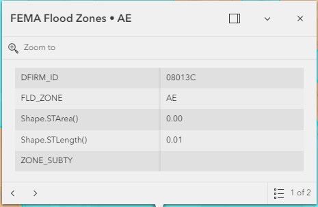
- DFIRM_ID is the FEMA effective Flood Insurance Rate Map (FIRM) panel ID
- FLD_ZONE is the FEMA effective flood zone, which is required to fill out the floodplain -development permit application.
Submittal Requirements
- Include a PDF of the property with flood zones (select ‘print’ at the top right of the screen).
- On the floodplain development permit, record the creek name and check the correct flood zone(s).
Elevation Verification Documentation
Elevation information must be filled in and supporting documentation attached. This permit will not be accepted with incomplete elevations or source documentation.
| Finished Floor Elevation (FFE) | the uppermost surfaceof a floor once construction has been completed but before any finishes have been applied |
|---|---|
| Base Flood Elevation (BFE) | the computed elevation that floodwater is anticipated to rise to during the 100- year flood event |
| Flood Protection Elevation (FPE) | is two feet abovethe BFE (AE Zone), twofeet above the defined flooddepth (AO Zones), or two feet above the highest adjacent grade (A Zone). |
| Highest Adjacent Grade (HAG) | is the highest elevation of the existing grade surrounding the structure. |
Elevation Source : Elevation Certificates
Elevation Certificates are a FEMA administrative tool that provide the Base Flood Elevation (BFE), the Finished Floor Elevation (FFE), and the Highest Adjacent grade (HAG). May be the best source for elevation verification documentation:
- Required for new structures and may be required for substantial improvements or modifications
- May be prepared and certified by a Licensed Land Surveyor or Licensed Professional Engineer, typically cost approximately $1,000 and take 1-2 weeks to complete for the best possible insurance rating.
- May be incorrect based on date of original certificate and changes to the floodplain map
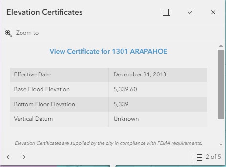
Your structure may already have an Elevation Certificate. Check the city’s interactive flood map:
- Enter project address into the search bar at the top right of the page, hit enter.
- Ensure the eyeball is open
 to display the Flood-Related Layers legend on the left side of the screen.
 - If an orange circled is present on the structure, click on it and click the arrow keys on the informational pop-up window to find the “Elevation Certificates” panel.
Submittal Requirements:
- Include a PDF of the elevation certificate
- On the floodplain development permit application, record the BFE, FFE, and HAG as determined by the Elevation Certificate. Compute the FPE by adding two feet to the BFE (Zones AE) or HAG (Zone A) and record on the permit application.
Elevation Source : Flood Insurance Study (FIS)
A FIS is a compilation of detailed flood elevation data for specific drainageways within a community that provides Base Flood Elevations (BFE). Elevations from the FIS can be determined for new structures or for structures with outdated Elevation Certificates:
- Required for fences in the Conveyance Zone.
- Required for Mechanical/Electrical/Plumbing Improvement or Remodel/Renovation if:
- no elevation certificate is provided, FFE is known and improvements are interior to structure
Elevations from the FIS (continued):
- Can be completed by a project engineer, architect, project manager or homeowner.
- Take approximately 1-2 hours to complete.
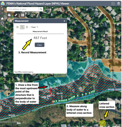
Step 1: Locate and Measure Structure on the FEMA Mapping Tool
- Open FEMA’s National Flood Hazard Layer (NFHL) Viewer and enter the project address in the search bar at the top left of the page.
- Use the measuring tool to measure the distance from the upstream edge of the project structure to the nearest cross section. Round the measurement to the nearest ½ foot.
- Locate the most upstream portion of structure and draw a line from that point perpendicular to the stream
- Use the measuring tool to calculate the distance from that point in stream to the upstream cross section. Round the measurement to the nearest ½ foot.
- The Base Flood Elevation (BFE) shall be calculated at the most upstream point where the structure intersects the 100-year floodplain. This means that the most upstream point of the structure shall be used to calculate the BFE and that BFE shall apply to the entire structure.
- Cross sections are typically lettered. Note the letter of the cross section that you measured to for use in the FIS report.
- In the example below, the distance measured to cross section K is 487-feet.
- Create a screen shot of the showing the lettered cross section used, the location of the structure and the measured distance between the two. Please include a copy of this PDF with your application.
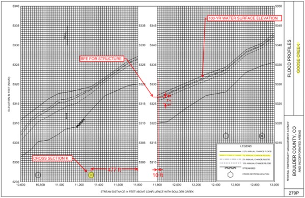
Step 2: Use the Stream Profile to Determine the BFE
As the name indicates, a stream profile provides a graph showing the flood elevations in profile view along a riverine flooding source. The profiles contain information for at least the base flood (1-percent- annual-chance or 100-year flood). Many reports also show stream profiles for the 10-percent (10-year), 2- percent (50-year), and 0.2-percent (500-year) flood elevations. It is critical to use the 100-year flood elevations when determining the BFE. Note that the FIS profile cannot be used to determine the HAG around a structure.
- Open FEMA’s Flood Map Service Center and find a copy of the Stream Profile from the Flood Insurance Study (FIS):
- Enter the address of the structure and click ‘Search’
- When taken to the next page confirm that you are in the right location
- Click ‘Show ALL Products’
- Click the folder labeled, ‘Effective Products’
- Click on ‘FIS Reports’
There are nine volumes of the FIS. Click Download for any of the products and the Table of Contents will direct you to the location of your Stream Profile (found on FEMA’s online mapping tool) in the correct volume of the FIS reports.
- Determine the 100-year Base Flood Elevation
- The elevations listed at each cross section are only applicable if a subject of determination is located directly on a mapped cross section. If a property is upstream or downstream of a cross section, the stream profile must be used to obtain the specific BFE applicable to the property
- Each profile has a horizontal and vertical scale. It is critical to determine these scales as the vertical and horizontal scales differ, and without correctly determining them it will not be possible to correctly determine the BFE.
- In the example below, the elevation increases by 5 feet per 10 squares. Therefore, the vertical scale is ½ foot to 1 square (5 feet / 10 squares = 0.5 feet/square). So, in order to increase the elevation by a foot, you would need to go up two squares. Continuing with our example below, the horizontal distance changes by 200 feet over 10 squares. Thus, the horizontal distances changes by 20 feet to 1 square. In order to move upstream by 100 feet you would need to move over 5 squares to the right.
- Bear in mind that the Stream Profiles are orientated with upstream on the right side of the profile and downstream on the left.
- In our example, 487 feet upstream (right) of Cross Section K is some 24.4 squares (487 feet / 20 feet/square = 24.4 squares). Measure upstream (right) of Cross Section K, approximately 24.4 squares to where a perpendicular line from Cross Section K intersects the 100-year water surface elevation. This point is 3.25 squares or 1.7 feet (3.25 squares * 0.5 feet/square = 1.625 feet à 1.7ft) above the elevation of 5325 feet. Therefore, our BFE is 5326.7 feet. So, in our example, 487 feet upstream of cross section K, is a BFE of 5326.7 feet.
Submittal Requirements:
- Include a PDF of the screen shot from Step 1 showing the lettered cross section used, the location of the structure and the measured distance between the two.
- Include a PDF of the FIS stream profile from Step 2 showing the lettered cross section used, the location of the structure and the measured distance between the two.
- On the floodplain development permit application, record the BFE determined from the FIS and the FFE provided in your construction drawings.
Note: Two-mile Canyon Creek and Boulder Creek have many split flows that can make determining a BFE difficult. If you are having difficulty, please contact the Floodplain Administrator for assistance.
Elevation Source : City Flood Map
The City flood map provides general Base Flood Elevations (BFE) and approximate Highest Adjacent Grades (HAG). This method is the least accurate and will only be accepted if previous options are not available. City flood map elevations:
- Required for exterior improvements such as rooftop solar, new electrical panels, or other mounted equipment. May also be used for modest site improvements such as a new driveway or parking area.
- Can be completed by the project engineer, architect, project manager or homeowner
- Take approximately 15-30 minutes to complete.
Open the city’s interactive flood map:
- Ensure that “FEMA Layers” is checked on in the left side bar.
- Ensure that the Base Flood Elevations layer and the Flood Hazard Zones layer are also checked on (these are nestled under the FEMA Layers group)
- It may be helpful to uncheck the “Effective Mapping” layer
- Enter the project address into the search bar at the top right of the page, hit enter.
- Zoom into the property
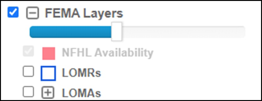
- You can adjust the transparency of the flood layers using the slide bar at the top of the left side bar
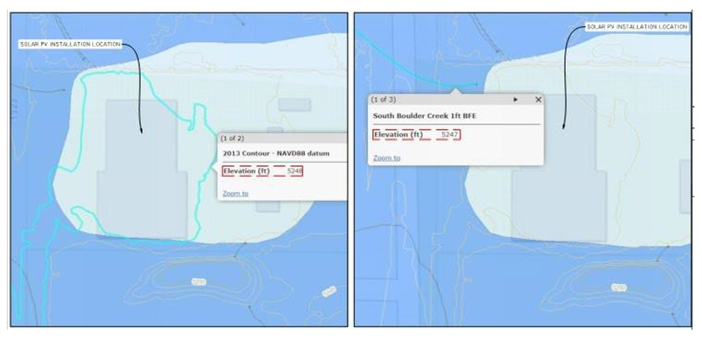
- Click on the Base Flood Elevation lines that intersect (or would intersect) the structure, and a pop-up window will open.
- Identify the flood elevations that intersect the building in this pop up under Elevation (ft)
- Use the most restrictive (highest) elevation that intersects the building as your BFE
- In the same map, and while remaining zoomed into the property, click on the Contours layer in the left side bar. You may need to zoom in further for the contours to appear. You can click on the contour lines and a pop up will appear with that contour’s elevation. Identify the contour elevation at the location of the work.
Submittal Requirements:
- Include a PDF of the screen shot with the intersecting Base Flood Elevation highlighted (see example above).
- Include a PDF of the screen shot with the intersecting contour highlighted (see example above).
- On the floodplain development permit application, record the BFE and HAG determined from the map.
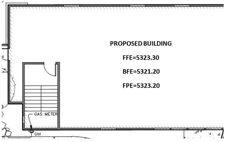
Construction Drawings Demonstrating Elevations
The Finished Floor Elevation (FFE), Base Flood Elevation (BFE) and Flood Protection Elevation (FPE) should be clearly called out on on site layout and elevation sheets:
New Mechanical, Electrical, Hvac, and Other Service Equipment Installed Above FPE
Provide mounting heights on the plans that show the proposed mechanical, electrical, HVAC, AC or service equipment will be installed above the Flood Protection Elevation.
| Item | Mounting Height | Plan Drawing or Sheet Number (n/a if not applicable) |
|---|---|---|
| Water Heater | 0.5 ft Above Finished Floor | A3 |
| HVAC | 0.75 ft A.F.F. | A5 |
| AC Unit | 1.25 ft A.F.F. | A4 |
| Electrical Panels/Junction Boxes | 2.0 ft A.F.F. | A4 |
| Gas Meter | 1.0 ft A.F.F. | A3 |
| Other |
Submittal Requirements:
- Complete and include the table above directly on the construction drawings, or
- Complete and include a PDF copy of the table above with your application.
New Sanitary Sewer Connections Installed Above FPE
Provide mounting heights on the plans that show proposed plumbing will be either be elevated above the Flood Protection Elevation or backflow prevention will be installed on the sanitary sewer connection line (examples shown in italics).
| Item | Mounting Height | Plan Drawing or Sheet Number (n/a if not applicable) |
|---|---|---|
| Shower | On second floor | A3 |
| Sink | Lip of sink at 5423.2 (2 feet above BFE) | A5 |
| Floor Drain | n/a (backflow prevention to be installed) | n/a |
| Toilet | Toilet lid at 5426.3 (2 feet above BFE) | A4 |
| Backflow Prevention | To be installed | A3 |
| Other |
Submittal Requirements:
- Complete and include the table above directly on the construction drawings, or
- Complete and include a PDF copy of the table above with your application.
Flood Damage Resistant Construction Materials Installed Above FPE
Provide confirmation that construction materials shall be flood damage resistant to 2-feet above the Base Flood Elevation (examples shown in grey italics).
| Item | Description of Material | Plan Drawing or Sheet Number (n/a if not applicable) |
|---|---|---|
| Insulation | Sprayed polyurethane foam | A4 |
| Drywall | Fiber reinforced gypsum exterior sheathing | A4 |
| Paint | Latex | A4 |
| Flooring Finishes | Tile, Concrete | A6 |
| Subfloor | Existing Plywood, Marine Grade Plywood | A6 |
| *All Other Finishes | Flood Damage Resistant Per FEMA NFIP Technical Bulletin 2 |
*Note: all other finishes that do not adhere to FEMA NFIP Technical Bulletin 2 are installed at the owner’s own risk. All other finishes are not required to be flood damage resistant by the city, however, in the event of a flood their replacement may not be covered by flood insurance.
Submittal Requirements:
- Complete and include the table above directly on the construction drawings, or
- Complete and include a PDF copy of the table above with your application.
Substantial Improvements
If the project cost exceeds 50% of the assessed structure value, the structure must be brought into compliance with current flood regulations. This means non-residential strutures must be floodproofed and residential structures must be elevated two feet above the Base Flood Elevation.
| Total Costof Project | includes all materials, laborand time of professionals and contractors, and the cost of any and all permits |
|---|---|
| Assessed Value of Structure | actual value of the structure, not including land |
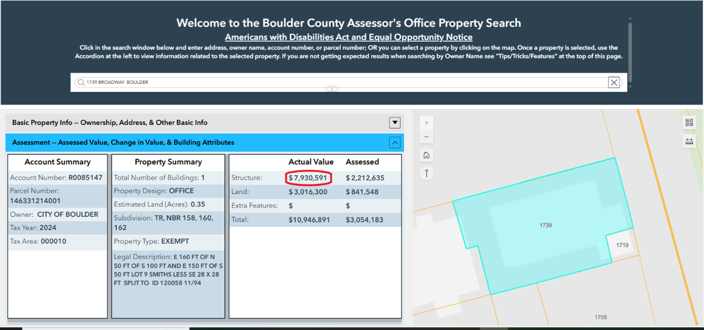
To find the assessed value of the structure:
- Open Boulder County Accessor’s Office Property Search.
- Enter the project address in the search bar at the top of the page.
- In the table on the left, click ‘Assessment’. In the Total Account Value table, under the heading Actual Value, find the structure value. This is the assessed value of the structure.
Submittal Requirements:
- Include a PDF of the Total Account Value table from the Boulder County Assessor’s Page.
- On the floodplain development permit application, record total cost of the project and assessed value of the structure.
Pre-FIRM
The first FEMA Flood Insurance Rate Map (FIRM) to feature any Special Flood Hazard Areas within the City of Boulder became effective in July 1978. If the structure was constructed prior to this date, it may qualify as a pre-FIRM structure. This means the structure may be exempt from current floodplain development standards.
| Substantial Improvement Threshold | Regulations apply |
|---|---|
| Substantial Modification Threshold | Regulations apply |
| Lateral Additions | Regulations may apply |
| Vertical Additions | Regulations may apply |
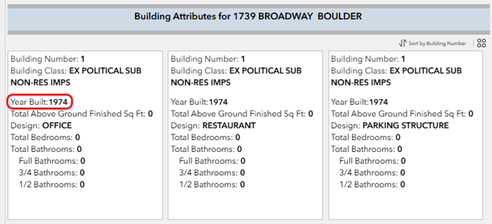
To find the year of construction of the structure:
- Open Boulder County Assessor’s Office Property Search.
- Enter the project address in the search bar at the top of the page.
- In the table on the left, click ‘Assessment’. Scroll down to ‘Building Attributes‘ and find the date of construction under ‘Year Built‘. (Note: If the year of construction is missing from the County Assessor’s website, please refer to the original deed for the property.)
Submittal Requirements:
- A floodplain development permit is still required for pre-FIRM structures.
- If a structure is pre-FIRM please note the year the structure was built and call it out as a pre-FIRM structure in the floodplain development permit application’s project description box.
New Residential Structures in the 100-Year Floodplain
For new residential structures in the 100-year floodplain, please adhere to these additional design criteria:
Crawl Spaces
- Bottom of the crawlspace must be two feet from Lowest Adjacent Grade (LAG)
- Bottom of the crawlspace to the bottom of the next highest floor must be less than four feet
- Insulation must be spray foam or closed cell
Submittal Requirements:
- Call out Finished Floor Elevation, Lowest Adjacent Grade, Elevation at Bottom of Crawl Space and any other pertinent elevations on all elevation sheets.
- Call out the type of insulation used on plan sheet.
Flood Vents
- Must be installed below Base Flood Elevation
- Must not be higher than one foot above adjacent grade
- Must provide adequate coverage for crawlspace
- Vents not meeting criteria must be certified by a Licensed Architect or Professional Engineer
Submittal Requirements:
- Show flood vent calculations on plan sheet
- Show flood vent installation (including adjacent grade and base flood elevation) on architectural and structural sheets
- Provide flood vent ICC-ES Certification or Licensed Architect/Professional Engineer certification
Basements
- New basements are not permitted in the 100-year floodplain (or in area of LOMR-F)
Projects in the Conveyance and High Hazard Zones
For projects in the conveyance and high hazard zones additional information is required for permit applications.
- Provide written response to the 15 criteria listed on the last page of the Floodplain Development Permit Application. If the response to the question is not applicable, please respond “n/a”.
- Projects must complete a public process that includes public notification. This step is completed by the Floodplain Administrator but adds a minimum of three weeks to final approval of permits
- Engineering Analysis may be required to determine if there are increases or decreases in the 100- year water surface elevations. If the project’s hydraulic analysis reveals any increase in water surface elevations or a decrease in water surface elevations of less than -0.3feet, a Conditional Letter of Map Revision will be required for the project. Increases in water surface elevations on insurable structures are not permitted under any circumstances.
- A completed Sign Posting Acknowledgment Form is also required for public process floodplain development permits. Signs informing the public of the planned work must be posted on the project property.
Understanding Flood Zones
The City of Boulder is home to Boulder Creek, its 14 tributaries and Boulder Slough (diverted water from Boulder Creek to fulfill irrigation company water rights). Due to our geographical location, the City of Boulder has the highest risk of flash flooding in the state of Colorado. Many neighborhoods throughout the city experience flooding during storm events, and some are at a higher risk to more extreme flooding due to their proximity to a major drainageway.
To mitigate flood risk, the City regulates to three different flood zones: the 100-year floodplain, Conveyance Zone (also referred to as the FEMA Floodway) and the High Hazard Zone.
What Is the 100-Year Floodplain?
The 100-year flood event has a 1 in 100 (or 1%) chance of occurring in any given year. Don’t let that fool you, though, over a 30 year mortgage there is a 26% chance that a property in the 100-year floodplain will be flooded. For comparison:
| Event | Odds |
|---|---|
| Structure in 100-year floodplain being flooded over a 30-year mortgage | 1 in 4 |
| Chance of Cubs winning the world series in 2016 | 1 in 6 |
| Structure in 100-year floodplain being flooded in any given year | 1 in 100 |
| Annual chance of being killed in a car accident in Colorado | 1 in 11,000 |
| Annual chance of being struck by lightning | 1 in 700,000 |
| Winning the Powerball Lottery jackpot | 1 in 292,000,000 |
What Is the Conveyance Zone (Or FEMA Floodway)?
The Conveyance Zone (also known as the Floodway) is the area of the 100-year floodplain that is reserved for the passage of flood waters and acts as a preservation zone for flood flows along the creek corridor.
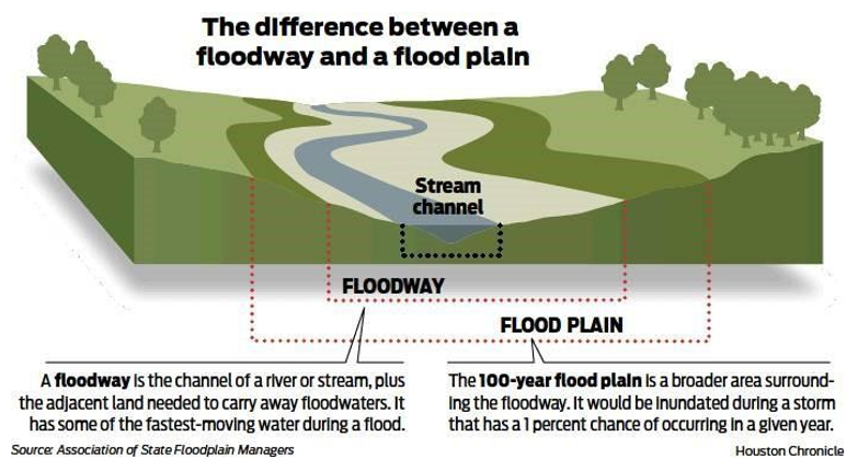
What is the Conveyance Zone (continued):
Floodways can be modified, but the applicant must be able to show that the project causes no-rise in the 100-year flood level. This typically requires an engineer to perform a hydraulic analysis.
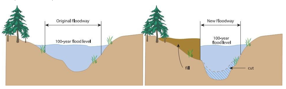
Example of Floodway Modification
What Is the High Hazard Zone?
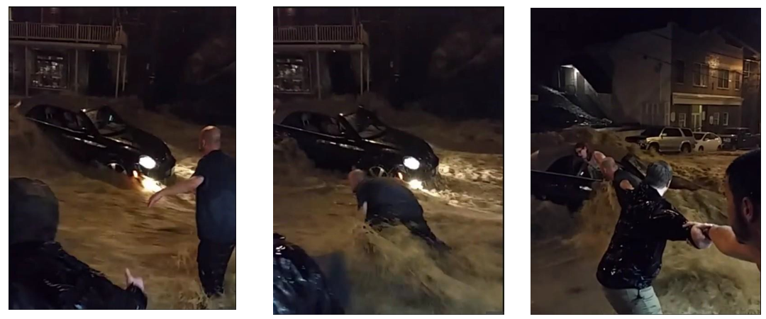
The High Hazard Zone represents areas in the 100-year floodplain where a high risk to human safety exists. Within the High Hazard Zone floodwater depth equals or exceeds four feet, or where floodwater velocities and depths are such that there is potential for floodwaters to sweep people off their feet.
The pictures below demonstrate that shallow flooding, when moving at high velocities, can sweep people off their feet and wash cars downstream. See the full story.
Summary of Development Regulations for each Flood Zone
Each flood zone is subject to development regulations and dependent on the project type or type of development.
Development Regulations for the 100-Year Floodplain
| Residential | Non-Residential | Mixed-Use |
|---|---|---|
|
|
|
|
|
|
|
|
|
|
|
|
|
|
|
|
|
|
|
|
|
|
|
|
|
|
|
Development Regulations for the Conveyance Zone (FEMA Floodway)
The Conveyance Zone is subject to all development regulations of the 100-year floodplain. In addition, the following restrictions apply:
| Residential | Non-Residential | Mixed-Use |
|---|---|---|
|
|
|
|
|
|
demonstrate a ‘no-rise’. |
demonstrate a ‘no-rise’. |
demonstrate a ‘no-rise’. |
|
|
|
Additional restrictions apply for development in the Conveyance Zone of South Boulder Creek. Please contact the Floodplain Administrator for assistance.
Development Regulations for the High Hazard Zone
The High Hazard Zone is subject to all development regulations of the 100-year floodplain and Conveyance Zone. In addition, the following restrictions apply:
| Residential | Non-Residential | Mixed-Use |
|---|---|---|
|
|
|
|
|
|
|
|
|
|
| |
|
|
|