View the Fact Sheet

View the printable Fact Sheet PDF or explore this page for the web-accessible version.

pdf preview

Iris Avenue in Context

The city’s Core Arterial Network initiative is focused on making the city’s busiest streets safer, more comfortable, and more connected. These streets provide the most direct and convenient route to everyday destinations for everyone, no matter how they travel.

Iris biking icon

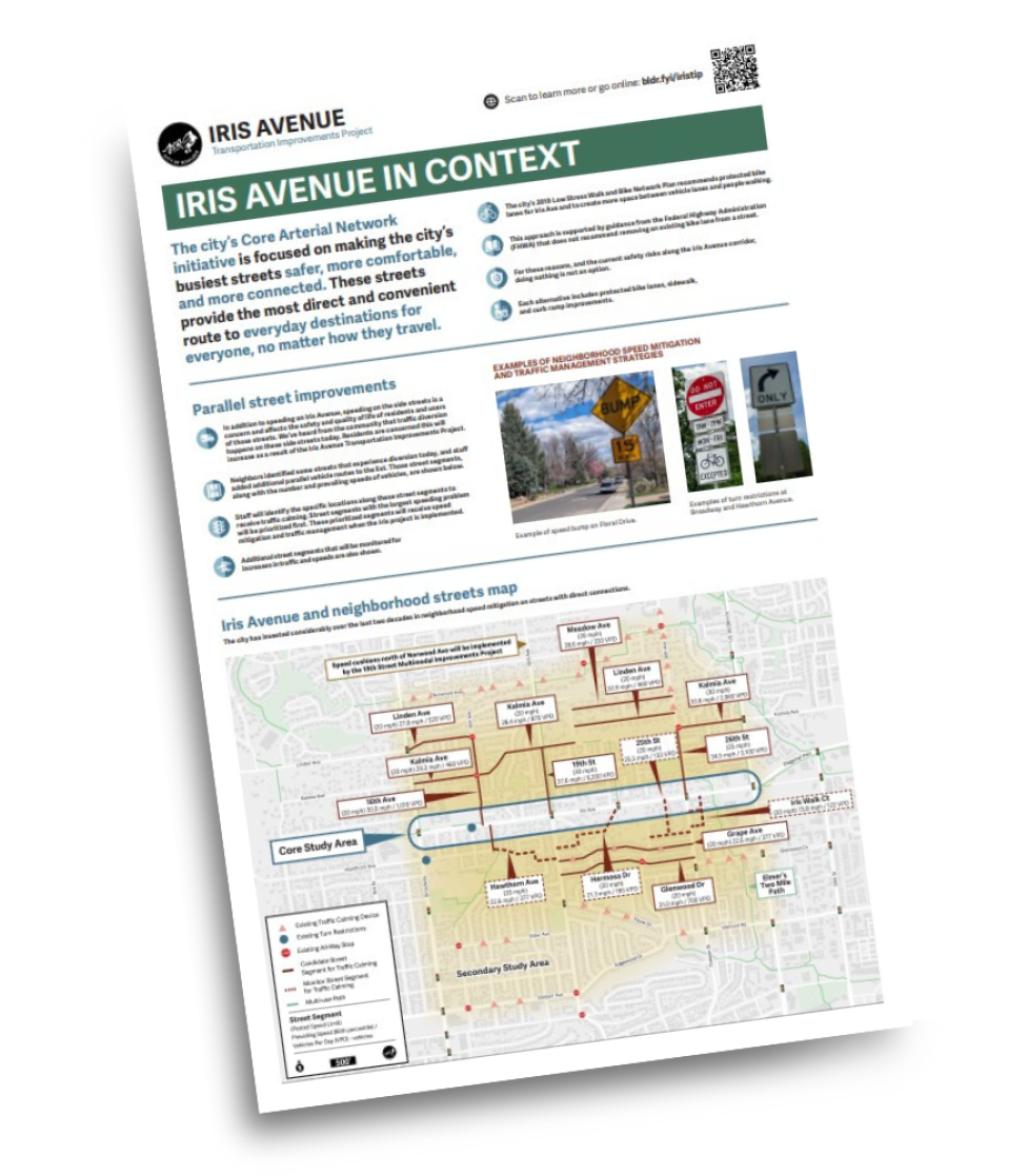
The city’s 2019 Low Stress Walk and Bike Network Plan recommends protected bike lanes for Iris Ave and to create more space between vehicle lanes and people walking.

Iris guidelines icon

This approach is supported by guidance from the Federal Highway Administration (FHWA) that does not recommend removing an existing bike lane from a street.

Iris safety icon

For these reasons, and the current safety risks along the Iris Avenue corridor, doing nothing is not an option.

Iris alternatives icon

Each alternative includes protected bike lanes, sidewalk, and curb ramp improvements.

Parallel street improvements

speeding icon

In addition to speeding on Iris Avenue, speeding on the side streets is a concern and affects the safety and quality of life of residents and users of those streets. We’ve heard from the community that traffic diversion happens on these side streets today. Residents are concerned this will increase as a result of the Iris Avenue Transportation Improvements Project.

Street icon

Neighbors identified some streets that experience diversion today, and staff added additional parallel vehicle routes to the list. Those street segments, along with the number and prevailing speeds of vehicles, are shown below.

traffic light icon

Staff will identify the specific locations along these street segments to receive traffic calming. Street segments with the largest speeding problem will be prioritized first. These prioritized segments will receive speed mitigation and traffic management when the Iris project is implemented.

traffic increase icon

Additional street segments that will be monitored for increases in traffic and speeds are also shown.

Examples of Neighborhood Speed Mitigation and Traffic Management Strategies

Yellow caution sign alerting vehicles of a speed bump ahead on Floral Drive with a speed limit of 15 miles per hour.
Example of speed bump on Floral Drive.
A red and white, Do Not Enter, sign posted for Monday through Friday between 7 a.m. and 7 p.m., except for bikes. There is also an image of a right-turn only sign.
Examples of turn restrictions at Broadway and Hawthorn Avenue.

Iris Avenue and neighborhood streets map

The city has invested considerably over the last two decades in neighborhood speed mitigation on streets with direct connections.

Iris Avenue and Neighborhood Streets Map. Long description on fact sheet webpage under header map long description.

This is a text alternative to the map. A detailed neighborhood street map illustration showing existing traffic calming devices along Balsam Avenue, Valmont Road, Floral Drive, Elder Avenue, Glenwood Drive, Grape Avenue, 26th Avenue, and Norwood Avenue. The map shows where existing turn restrictions are located on Broadway and Iris Avenue near 16th Avenue. The map also outlines where candidate street segments are located for traffic calming on Glenwood Drive, Grape Avenue, Kalmia Avenue, Linden Avenue, and Meadow Avenue. The city is monitoring streets for traffic calming at Hawthorn Avenue, Hermosa Drive, 25th Street, and Iris Walk Court. The map notes that speed cushions north of Norwood Avenue will be implemented by the 19th Street Multimodal Improvements Project.

View all project fact sheets & learn more