View the Fact Sheet

View the printable Fact Sheet PDF or explore this page for the web-accessible version.

pdf preview

Existing vehicle travel time

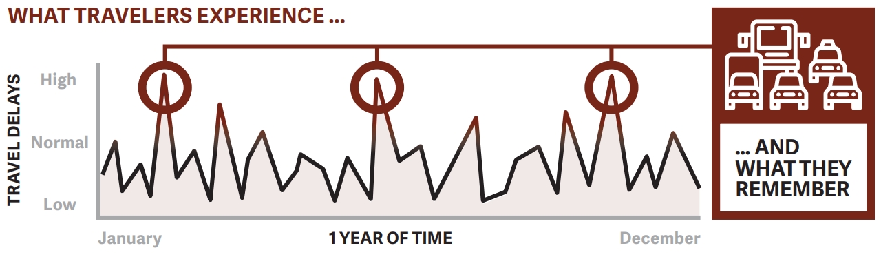
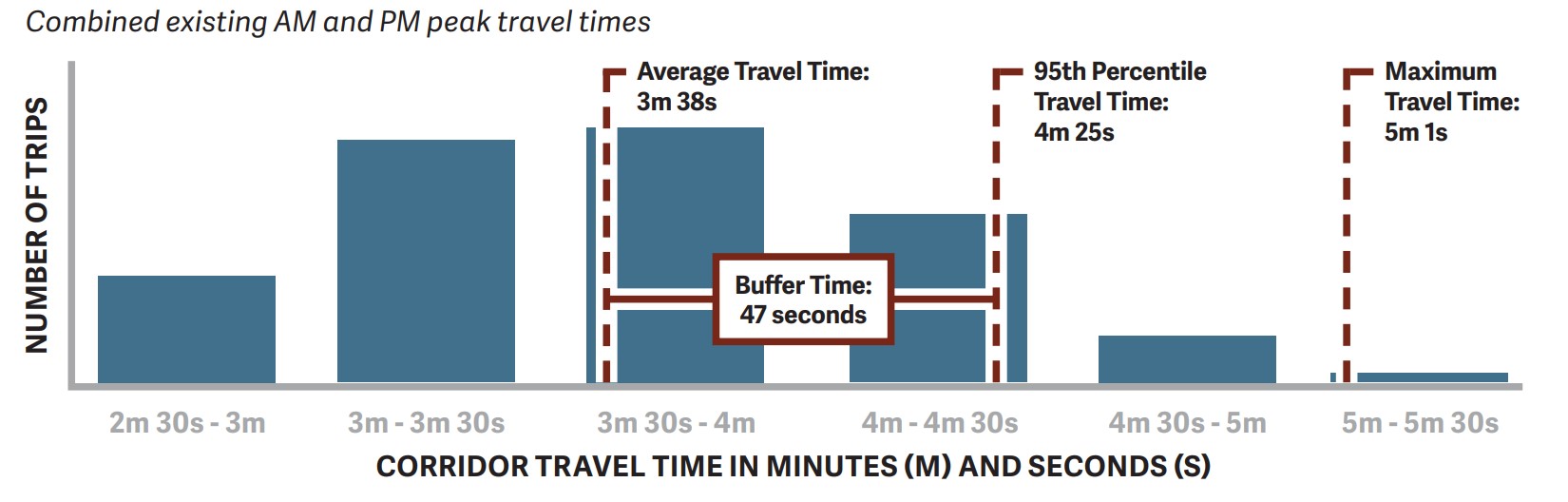
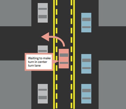
Current travel time varies by direction, time of day, speed limit compliance, and seasonal variability such as school being in session.

Existing A.M., Midday, and P.M. Peak Hours Data

  • The average travel time is between 3 and 4 minutes.
  • The 95th percentile travel time indicates about how long the slowest trips take along the corridor (only 5% of data were slower than this travel time). They represent a small number of overall trips but it may be what people driving remember the most. For Iris, these longest trips can take between 4 and 5 minutes today.

How Is This Data Collected?

This set of existing conditions data was collected in Fall 2023 using Bluetooth detection systems. End-to-end travel times are measured from the center of the intersection and include any time spent waiting in queued traffic on a red signal at the corridor ‘bookend’ intersections.

What Travelers Experience

Chart for illustration purposes showing travelers remember busiest times on the road even though they experience less busy times.

Chart for illustration purposes only. Travel times typically vary by direction, time of day, and speed limit compliance.

Iris Avenue Existing Vehicular Travel Time in Minutes (m) and Seconds (s)

Analysis Time Period Minutes (m) Seconds (s)EastboundWestbound
AMMiddayPMAMMiddayPM
Average Travel Time3m 43s3m 43s4m 12s3m 23s3m 36s3m 25s
95th Percentile Travel Time4m 13s4m 54s4m 59s 4m 13s4m 40s4m 16s

Iris Avenue Travel Time Distribution

Iris Avenue travel time distribution graph. The key takeaway is the travel time distribution, indicating that the average travel time is 3 minutes and 38 seconds, with a 95th percentile travel time of 4 minutes and 25 seconds, and a maximum travel time of 5 minutes and 1 second.
Combined existing AM and PM peak travel times. View full travel time distribution image.

Existing vehicle traffic volumes

  • Daily traffic volumes (vpd) vary along the corridor and are evenly split by direction.
  • Daily traffic volumes west of Folsom Street/26th Street are comparable to Arapahoe Avenue west of Folsom Street/26th Street, Valmont Road east of 47th Street and 28th Street north of Palo Parkway.
  • Peaking of weekday traffic volumes during the AM period occurs over a relatively short timeframe between 8 to 9 a.m. Traffic volumes drop off slightly throughout the middle of the day before picking up again for a longer PM period of peak traffic volume from 3 to 6 p.m.
  • Peak hour volumes are heavier in the westbound direction in the AM and eastbound in the PM.
  • Historical data suggests that daily traffic volumes along the corridor have remained consistent over the past 20 years.

Iris Avenue Corridor Daily Traffic Volume and Daily Direction Split Between Eastbound and Westbound

LocationEast of 16th StreetEast of 19th StreetEast of 26th Street/ Folsom Street
Vehicles per Day (vpd)15,930 vpd20,040 vpd21,350 vpd
Daily Direction Split (Eastbound and Westbound)EB 50.9%WB 49.1%EB 50.5%WB 49.5%EB 51.4%WB 48.6%

Iris Avenue Corridor Peak Vehicles per Hour (VPH)

Street LimitsBetween Broadway
and 19th Street
Between 19th Street
and 26th Street/
Folsom Street
Between 26th
Street/Folsom Street
and 28th Street
DirectionEastboundWestboundEastboundWestboundEastboundWestbound
AM571 vph 679 vph 714 vph796 vph 763 vph937 vph
Midday607 vph 554 vph 724 vph 713 vph768 vph698 vph
PM709 vph 651 vph 869 vph 851 vph 961 vph 799 vph

Safety improvements and potential travel time changes

How Did Existing Conditions Inform the Conceptual Design Alternatives?

As the project team developed conceptual designs for potential corridor improvements, it was learned with preliminary traffic analysis that the “bookends” of Iris Avenue are key to keeping all people moving through the corridor.

The conceptual designs for all four alternatives limit vehicle lane reconfiguration to between 13th Street and Folsom Street/26th Street. These extents were informed by preliminary traffic analysis that showed extending a three-lane configuration to the bookend intersections (Broadway and 28th Street) would significantly increase delay and travel time.

This analysis informed the maintenance of today’s vehicle lane configurations at both bookends to ensure the advancement of the community priorities: vehicle travel time and safety improvements for all.

Potential Increases To End-To-End Travel Times for All Alternatives

There will be some travel time delay associated with all four alternatives due to street design changes that advance Vision Zero Action Plan goals by moderating vehicle speeds, accommodating protected bike lanes, and modifying intersections to reduce conflicts between modes. This will vary by direction, time of day, and seasonal variability such as school being in session.

Depending on the direction and time of day, our analysis shows that average travel time changes may vary by +3 seconds to +1 minute 3 seconds for Alternatives A & B. Travel time changes for Alternatives C & D vary by +1 second to +25 seconds.

95th percentile travel time changes may vary by +2 seconds to +1 minute 4 seconds for Alternatives A & B and +2 seconds to +36 seconds for Alternatives C & D.

The four alternatives are informed by community input, city policies, analysis, and professional best practices. While the potential travel time changes may feel impactful to some, the four alternatives prioritize safety for all.

Vehicle turning movements

Two-way left turn lanes help with all turning movements on and off of Iris and help with traffic flow by removing turning vehicles from through lanes. At signalized intersections, high volume turns crossing the protected bike lanes will utilize dedicated or protected signals to improve safety for all.

Emergency response

Quick response to emergencies and natural disasters is a priority for the city. Day-to-day emergency response and disaster emergency response are two of several key considerations for the project. The conceptual designs for improvements to Iris Avenue were informed by input from the city’s Boulder-Fire Rescue (BFR) and Police (BPD) departments, and the Office of Disaster Management (ODM) for the City of Boulder and Boulder County. We will continue to work closely with them throughout the design process.

Two Common Questions We Receive About Alternatives a & B Are Answered Below

Day-To-Day Emergency Response

The illustration shows a typical three-lane street with a two-way left turn lane on how it functions for day-to-day emergency response by having emergency vehicles can use the two-way left turn lane for quick response to emergencies.
The Boulder-Fire Rescue and Police departments can use the center turn lane for emergency operations. View full day-to-day emergency response image.

Disaster Emergency Response

Iris disaster emergency response. Details under Disaster response long description header.
In a disaster scenario, the two-way protected bike lane in Alternative B is wide enough to accommodate emergency vehicles. View full disaster emergency response image.

Intersection and driveway access along Iris Avenue

Deliveries, loading, and trash collection

and trash collection There are a small number of driveways along Iris Avenue that access homes. Many have large off-street areas or a pair of driveways that allow for deliveries and loading to occur off-street. As a result, traffic impacts will be minimal.

Currently, two separate Western Disposal trucks empty trash and compost or recycling bins every week. The next phase of design will work with Western Disposal to identify locations to store bins on collection days to optimize operations and minimize impacts to all members of the traveling public.

North side alignment for the two-way protected bike lane

Two-way protected bike lanes require intentional design at driveways and unsignalized intersections because drivers must expect cyclists coming from both directions. These designs include clear signage and markings as well as raised crossings where conditions allow.

The north side alignment for Alternatives B & D was preferable due to fewer conflict points and more sun exposure in the winter months than the south side. Between Broadway and 28th Street, the north side has 8 driveways and 5 unsignalized intersections totaling 13 conflict points, while the south side has 34 total conflict points with 24 driveways and 10 unsignalized intersections.

Protected Bike Lane Considerations: One-Way or Two-Way?

People biking on one-way protected bike lanes travel in the same direction as vehicles on both sides of the street and experience more conflict points along the corridor. People biking on two-way protected bike lanes travel in both directions on the north side of the street and experience fewer conflict points along the corridor. One-way protected bike lanes are narrower which poses challenges for snow plowing as well as street sweeping. Two-way protected bikes lanes are wider and allow for easier passing and side-by-side bike riding. Both protected bike lane designs include adjustments to turn signal phasing to separate biking and vehicle turning movementsto avoid conflicts when driving across the protected bike lane

This is an text alternative to the travel time graphic. Core Study Area Iris Avenue graphic titled Potential increases to end-to-end travel times for all alternatives. The average increase is between 1 second to 1 minute 3 seconds. The 95th percentile is an increase between 2 seconds to 1 minute 4 seconds. The maximum increase is between 0 seconds to 2 minutes 9 seconds. With call-out boxes stating there are end-to-end improvements including bike lanes as well as sidewalk and bus stop upgrades. A second call-out mentions there are four conceptual design alternatives developed between 13th Street and Folsom Street/26th Street with end-to-end travel times which include any time spent waiting at booked intersections.

This is a text alternative to the disaster emergency response graphic. The illustration shows a three-lane street with a two-way left turn lane and a two-way protected bike lane. In a disaster scenario, the two-way protected bike lane in alternative B is wide enough to accommodate emergency vehicles. The center turning lane is used as a second eastbound evacuation lane. A callout says the roadway design features for the use of the center turn lane as a second eastbound evacuation lane are being coordinated with ODM, BPD and BFR.

This is a text alternative to the access map. The map shows the intersection and driveway access along Iris Avenue between Broadway and 28th Street. There are unsignalized intersections or commercial driveways at 13th Street, 14th Street, 15th Street, 16th Street, Iris Court, 17th Street, 22nd Street, Hermosa Drive, 25th Street, with five unsignalized intersections or commercial driveways between Folsom Street and 28th Street. The map includes 23 residential or low volume driveways between Broadway and 28th Street and five residential properties with two driveways between 16th Street and 22nd Street on Iris Avenue. There are five off-street parking areas between 16th Street and 25th Street.

View all project fact sheets & learn more