With bikeable trailheads, shuttles, transit-friendly routes and improved regional connections, there are more ways to access Boulder’s open space.
Consider leaving your car at home for your next outdoor adventure with Boulder’s Open Space and Mountain Parks. With bikeable trailheads, shuttles, transit-friendly routes, improved regional connections, and even shared scooters and bikes, there are more ways than ever to access Boulder’s open space.
The city is working to expand trailhead access and build new trail connections that help people reach open space more easily, reduce emissions, ease congestion and improve the outdoor experience for everyone. While more improvements are on the way, many options are already available to reach open space without a car.
Ride or Roll to the Trailhead within the City
- Bikes and e-bikes: OSMP trailheads in Boulder are bikeable for many community members and offer several racks for secure parking. Throughout 2025, the city is investing in more bike racks at area trailheads and access points throughout many neighborhoods to improve biking access. View a map of biking trails in Boulder. Learn more about where e-bikes are allowed on city open space.
- Park-to-Park shuttle: The Park-to-Park shuttle provides free satellite parking and free shuttle service to and from Chautauqua Park on summer weekends and holidays, from Memorial Day weekend through Labor Day.
- Shared bikes and scooters: While operating Lime scooters on city open space is not permissible, you can take a Lime scooter to most trailheads within city limits (like Sanitas and Chautauqua). There are two Lime Groves near Chautauqua (8th and Baseline, and Baseline between Lincoln and 10th) that are within a mandatory parking zone. There are discounts for income-qualified community members and adaptive e-scooters for community members experiencing disabilities. You can also take an e-bike to a few trailheads including the Peoples’ Crossing and Chautauqua. The city’s bike sharing partner, BCycle, has a variety of stations throughout the city. Learn more about micro-mobility in Boulder.
- Bus to local trailheads: Several OSMP trailheads are accessible from nearby bus stops. See bus schedules and stops.
Shuttle to Nature
- Eldo shuttle: This free shuttle bus service operates on weekends and holidays during the summer and fall, carrying passengers from U.S. Highway 36 and McCaslin Boulevard or from Boulder to Eldorado Canyon State Park, as well as to the Marshall Mesa, Doudy Draw and South Mesa trailheads. During 2025, the city is also conducting trailhead improvements to improve shuttle access at area trailheads.
- Hessie trailhead shuttle: The free shuttle provides service between Nederland High School and the Hessie Trailhead. In 2025, the free shuttle service runs Friday to Sunday from May 24 through October 6. Combine the Hessie Shuttle with RTD’s NB Route and leave your car at home.
Visit Regional Trails and Connections
- Longmont-to-Boulder Trail: The Longmont-to-Boulder (LoBo) Regional Trail is a 12-mile system that runs through Gunbarrel, Niwot and open space properties connecting the City of Boulder with the City of Longmont.
- U.S. 36 Highway Bikeway: People can connect to this regional trail, which heads to the northwest Denver metro region, from the city’s South Boulder Creek Trail.
- North Sky Trail: The new trail links Foothills Trail in north Boulder to the Joder Ranch Trail, which connects to Left Hand Canyon.
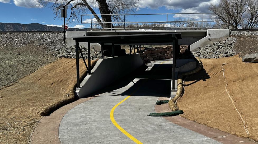
- Four Mile Canyon Creek Trail Underpass: This connects the city’s Fourmile Canyon Creek Path to the Cottonwood Trail underneath the Diagonal Highway in northeast Boulder.
- IBM Connector Trail: This connection helps link Gunbarrel-area residents to Boulder Reservoir and Boulder Valley Ranch trails in north Boulder. Bicyclists can use area roads to enter the city.
Learn About New Connections
- Valmont Road Multi-Use Path Project: The City of Boulder has built a multiuse path near Valmont Road to provide an off-street connection from 61st Street to the existing pedestrian bridge and multiuse path at South Boulder Creek.
- Diagonal Highway 119 Bikeway: Construction has begun to create a nine-mile bikeway between Boulder and Longmont that will connect with OSMP’s IBM Connector Trail.
Keep Reading
News keep reading
-
Natural Partners in Wildfire Prevention: Boulder Expands Targeted Grazing Program
-
What is Boulder’s Climate Action Plan?
-
City of Boulder to Close Western Trails on Open Space and Mountain Parks (OSMP) Property Saturday, March 14
-
City of Boulder To Close All Open Space and Mountain Parks Property Friday, Dec. 19