Project Overview

The Open Space and Mountain Parks Department (OSMP) has launched a systemwide Multimodal Access Improvements Assessment to better understand how community members and visitors access open space lands and trails, and to identify opportunities to improve safe, sustainable and equitable access.

This assessment focuses on improvements within OSMP-managed lands to support access for hikers, runners, climbers, equestrians, bicyclists and wheelchair users. All potential improvements will be evaluated to ensure the protection of natural resources while maintaining high-quality visitor experiences.

The assessment will focus on OSMP-led actions and may include:

The multimodal assessment project will include these areas: trail connections, trailheads and access points, and education and outreach. Details below.
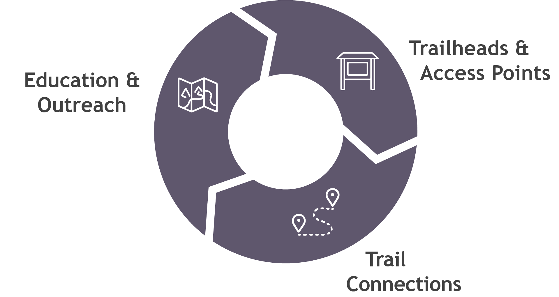
  • Trail connections that improve access within the OSMP trail system or link to nearby regional trail networks.
  • Trailhead and access point improvements, such as signage, wayfinding and safer multimodal access to entry points.
  • Education and outreach tools to better inform visitors about non-driving access options

While the primary emphasis is on OSMP lands, the project may also identify limited opportunities outside OSMP’s jurisdiction that support safer and more connected access.

Project Goals

  • Build a shared understanding of how visitors currently access OSMP lands
  • Identify gaps or barriers to accessing and using trails
  • Explore small, achievable improvements that support safety, connectivity, and sustainability
  • Ensure future decisions align with OSMP’s Charter purposes, ecological priorities, and visitor experience goals

Stay Informed and Involved

We want to hear from you!

Sign up for OSMP Fieldnotes Newsletter to stay informed about the project and learn about upcoming community input opportunities. There will be three community engagement windows, starting in Spring 2026.

Timeline and Project Phases

Multimodal Assessment Project phases, details below image.

Phase 1: Background Research & Assessment (2025 Q4 - 2026 Q1)
Staff will build on existing data to understand how visitors currently access OSMP lands, including travel modes, visitation patterns, facility use and trail and access conditions. This phase will identify gaps and preliminary opportunities related to multimodal access.

Phase 2: Preliminary Opportunities & Strategies (2026 Q2)
Engagement Window 1 (April)
OSMP will share early findings and potential focus areas with the community and gather feedback through a public engagement window and an on-the-ground intercept survey.

Phase 3: Draft Package of Solutions (2026 Q3)
Engagement Window 2 (August)
Using the feasibility analysis results and community input, OSMP will develop a draft package of potential improvements. A scoring framework will help evaluate options based on ecological impacts, safety, connectivity, feasibility and alignment with OSMP’s mission.

Phase 4: Refined Package of Solutions (2026 Q4)
Engagement Window 3 (November)
Staff will refine the draft recommendations based on additional feedback and bring forward a final package for review.

Phase 5: Council Action (if needed) (2027 Q1)

Multimodal Assessment FAQs

The Multimodal Improvements Assessment is a systemwide project led by the City of Boulder Open Space and Mountain Parks (OSMP) Department. It focuses on understanding how people access and move within open space and identifying opportunities to improve access using transportation options beyond driving, such as walking, biking, and transit.

Visitation to open space has increased over time, leading to congestion at trailheads and increased demand for access. This project supports the city’s climate and transportation goals by exploring ways to make it easier to access open space without relying on a car, while continuing to protect natural resources and visitor experience.

This assessment focuses on improvements that OSMP can directly implement, including:

  • Trail connections and allowed uses on trails
  • Trailhead improvements and potential new access point
  • Signage and wayfinding
  • Education and outreach to support multimodal travel

The project may also identify small, strategic improvements outside of OSMP-managed land where they could support safer and more connected access, but the primary focus is on OSMP lands.

OSMP is focusing on areas where the department has the ability to directly implement improvements. This helps ensure that recommendations from the project are feasible and can move forward in a timely manner.

At the same time, access to open space often involves connections beyond OSMP land. OSMP is already coordinating with partner agencies on these longer-term opportunities, and this assessment may help identify additional areas for collaboration to support safer and more connected access.

“Key trail connections” refer to trail links that could improve how people access or move through the open space system.

These connections can be:

  • Small, localized improvements that close short gaps
  • Larger connections that improve access between areas. Acknowledging that these solutions may be identified as later project efforts that OSMP would lead.

While many opportunities identified in this project may be smaller in scale, the term “key” is used to allow the evaluation process to determine which connections would be most beneficial and appropriate.

No decisions have been made yet. This project is an assessment to identify and evaluate potential opportunities. Any future trail projects would go through additional planning and review before being implemented.

There are two main ways to provide input during this phase:

  • Online Questionnaire: Open April 10 – May 3
  • Intercept Surveys: Conducted at select trailheads throughout April

You can also submit comments at any time through the project webpage.

Community feedback will help:

  • Identify barriers to accessing open space
  • Understand how people currently travel to trailheads
  • Inform preliminary opportunity areas and solutions
  • Guide future planning and investment decisions

This input will be combined with data analysis and staff expertise to help prioritize potential improvements.

It takes time to review and analyze all of the input from both the intercept survey and the online questionnaire. We anticipate beginning to share results with the public in June, starting with an update to the Open Space Board of Trustees (OSBT).

Intercept surveys are conducted at a variety of locations to capture a broad range of visitor experiences. Not sharing locations in advance helps ensure more representative feedback and reduces bias in who participates.

This project will not result in immediate changes. The Multimodal Improvements Assessment is expected to take about a year and includes multiple opportunities for public input throughout the process.

Any potential changes to trails, access, or allowed uses would come after the assessment is complete and would be informed by community feedback, data, and staff expertise. Some smaller improvements that don’t require additional design or permitting could begin as early as 2027, while more complex projects could take several years to implement.

Improving access by walking, biking, transit, and carpooling can help reduce vehicle trips and emissions. This project supports OSMP’s climate goals while balancing the need to protect natural resources and maintain a high-quality visitor experience.

For more information about the Multimodal Improvements Assessment, please contact:

Jena Van Gerwen
Open Space Planner, City of Boulder OSMP
vangerwenj@bouldercolorado.gov

Additional Materials

Accessibility Statement

The City of Boulder is committed to digital accessibility. Some content may not be fully accessible due to technical limitations or issues. For alternate formats or accommodations, please visit Accessibility | City of Boulder or contact accessibility@bouldercolorado.gov.