Why did the city choose 100-year flood protection for South Boulder Creek (SBC)?

The city has been evaluating flood mitigation options since 2010 and city council approved the SBC mitigation study in 2015. In June 2020, city council considered three different levels of flood protection (100-, 200-, and 500- year) and ultimately passed a motion in support of the 100-yr flood design concept. This concept was found to have the least environmental impacts, the lowest cost, and was identified to have the greatest probability of being permitted by the various regulatory agencies.

Why wasn’t 500-year flood protection chosen?

The project team evaluated five-hundred-year conceptual designs and determined they were not feasible given project constraints. Specifically, the 500-year design concept was unable to match existing hydraulic loading conditions on the bridge structure and not increase flooding downstream. In other words, if the 500-year flood occurred under two scenarios: 1) with the city’s optimized 500-year flood project concept in place, and 2) under existing conditions without any flood mitigation features, the water depths would be higher under the US36 bridge under the 500-year flood project scenario. This violates fundamental criteria of regulated floodplain planning in that projects cannot make downstream flooding conditions worse. The 100-year design does not violate such criteria.

What was the magnitude of the 2013 flood?

The prolonged rainfall event in September 2013 resulted in storm runoff citywide. The flood magnitude as measured throughout various parts of Boulder ranged between a 25- and 50-year event for many watersheds. Portions of lower South Boulder Creek, including the West Valley, experienced flows on the order of a 100-year event 1. A more detailed account is included in this flood history document.

The flood project is using a short-duration, high-intensity thunderstorm event as the basis for the design of the flood mitigation project. This type of storm is closest to the SBC flood flows experienced in 2013 despite the 2013 precipitation event being more characteristic of a long-duration, low-intensity general storm that results in lesser flood flows.
  1. The South Boulder Creek Flood Mitigation Project is Phase 1 of three phases of flood mitigation for the South Boulder Creek major drainageway. The project would mitigate flooding for approximately 2,300 residents, 260 structures and 1,100 dwelling units (a dwelling unit accounts for building like apartments that house more than one family/resident).
  2. The South Boulder Creek Project is estimated to cost $63 million and would be paid for through Storm/Flood utility ratepayers. A breakdown of cost is shown under Cost and Funding below.
  3. Landowner arrangements with CU, OSMP and CDOT are at various process stages. CU owns a portion of the project needed for flood mitigation and the policy framework established to date will require an annexation agreement for the flood project to advance. The 2019 CDOT requirement for above-ground structures to be placed outside of CDOT Right-of-Way, the Variant 1, 100-year floodwall requires an open space disposal. A right-of-way permit will also be required for components of the flood project.

How much does the flood project cost and will taxpayer money be used to fund the SBC project?

The total estimated flood project cost is $51M. The project will be paid for by Stormwater and Flood utility fees included in monthly utility bills and in partnership with the Mile High Flood District. Costs include costs for construction of Phase 1 from the South Boulder Creek mitigation plan. This includes the direct costs of constructing the flood mitigation structure (detention facility), as well as indirect project costs as outlined in the table below.

Cost Item 2022 30% Design Estimate (millions)
Flood Mitigation $51
Earthfill $4
CU South Impacts $0
OS-O Land Purchase $3
OS-O Restoration $5
Total $63

What are “Enterprise Funds” and what are they used for?

Enterprise Funds are generated through the collection of fees in exchange for services. City of Boulder flood and stormwater utility fees are collected through customer utility bills in exchange for flood and stormwater services and are used to pay for project construction as well as indirect project components. Indirect project components can include environmental mitigation, property acquisition and community engagement related to the project, among others. 

Can Enterprise Funds be used to pay for indirect project costs, such as earthfill and tennis courts?

Yes. Boulder’s flood projects are frequently in the position of not owning the land needed for flood improvements. In these situations, Boulder must negotiate with landowners to reach agreement for use of the property. Project funds can be used to pay for resulting components of landowner agreements. 

In the case of CU South, the university owns a portion of the land needed for the flood project. Boulder has been in negotiations with the university within the framework established in the 2017 Boulder Valley Comprehensive Plan (BVCP) CU South Guiding Principles. Prior to negotiating the current draft agreement, the flood project conservatively estimated costs for both direct project impacts and the implications of these guiding principles, including compensation for impacts to the university’s existing facilities (tennis courts, warehouse, and South Loop Drive) as well as other project elements needed to comply. Reducing costs for impacted CU facilities has been one of the focal points of annexation negotiations. As the flood design continues to progress, staff will continue to refine flood design details and associated cost estimates.

What is the “earthfill?” any why is the city paying for it?

The construction of the flood mitigation detention dam will change the current floodplain and will result in new areas of inundation that were previously outside of the floodplain. The project includes strategic placement of earthfill to maintain the existing floodplain extents to allow for future university development as agreed upon in the CU South Annexation Agreement. 

The concept for soil fill was recommended in the South Boulder Creek Flood Major Drainageway Plan (accepted by City Council in 2015). In recognition of multiple property interests, the recommended flood concept was developed to combine “excavation and fill to produce a configuration that minimizes the impacts to open space land and CU Boulder’s land.” During the course of annexation negotiations, the city was able to refine the flood design in such a way as to reduce the amount of earthfill needed and therefore reduce the related cost. 

Could the city condemn the CU South property instead of annexing?

The law regarding one government condemning the property of another is not settled. Whether a home rule city can condemn the property of a state university has not been addressed by the Colorado courts. 

What is the project schedule?

Project Activity Start Date End Date
Conceptual Design 2017 2020
Preliminary Design 2019 2022
Annexation 2019 2021
Design 2022 2024
Permitting 2020 2024
Construction 2024 2026

Does the city document titled “SUMMARY REPORT OF PRIVATE PROPERTY AND RESIDENT FLOOD IMPACT SURVEY AND ANALYSIS SEPTEMBER 2013 FLOOD DISASTER” (Nov. 4, 2014) change the priority of the South Boulder Creek Flood Mitigation Project relative to other city projects? 

The report is one data point to consider as the city assesses and prioritizes future work. Reprioritizing already planned flood projects or circumventing years of strategic planning solely based on the 2014 damage report would have serious life safety implications. Overall cost of property damage is, of course, one factor in prioritization of flood mitigation projects. Critical life safety and social equity issues, among others, are as important or more so. Of note when looking at the report is the fact that a $10 million outlier was excluded in the 100-year South Boulder Creek floodplain. The outlier is Fraser Meadows, which was one of the most impacted entities in the city during the 2013 flood. Accounting for the $10 million in impacts to Frasier Meadows would make South Boulder Creek the second highest impacted of the 13 major drainageways in the memo. 

As it relates to South Boulder Creek, the 2014 report would also not capture the serious threat to life safety that occurs when US 36 overtops and immediately and dramatically increases flooding to US 36 and downstream neighborhoods in the west valley as it did during the 2013 flood. Using prospective property damage as a sole consideration in flood mitigation would also skew flood projects towards neighborhoods with the highest property value, which would result in the most affluent neighborhoods receiving priority of city flood and stormwater utility resources to the detriment of lower income community members, which also has racial equity implications.  

The primary purpose of the city’s Stormwater/Flood Utility is to protect the public health, safety and welfare from stormwater runoff and floods.  We are continuing to review and update our approach to delivering these services with best available practices while also incorporating community values.  We are in the process of updating the Comprehensive Flood and Stormwater Master Plan with a key focus on updating and developing prioritization criteria for flood mitigation projects across the city.  We encourage the public to get involved in this effort and provide feedback. Please visit the Comprehensive Flood and Stormwater Master Plan webpage. 

Lastly, the South Boulder Creek Flood Mitigation project was initiated prior to the 2013 flood and is following city master planning and flood mitigation lifecycle of mapping, mitigation planning and then design and construction.  The current regulatory floodplain mapping was accepted by FEMA in 2010 and a basin-specific master plan was completed for South Boulder Creek in 2015 with the benefit of the 2014 damage information. Years of public process, careful consideration of alternatives and a process of elimination has brought the South Boulder Creek Flood Mitigation Project to its current state. 

Would an easement be an effective way of dealing with the property needed for the flood project so that more time could be allocated annexation negotiations? 

Boulder has been in annexation negotiations with the university according to the 2017 Boulder Valley Comprehensive Plan (BVCP) CU South Guiding Principles, which framework was established through years of public process. Starting over under an easement framework, which would essentially decouple the annexation and flood project, could set the project back by years or put it at risk entirely. The annexation agreement establishes critical integration parameters for the university’s property and the flood project footprint, including the flood detention inundation area. Without a signed annexation agreement to establish such things as the university’s development area, where their recreation facilities will be placed and arrangements for transfer of open space and associated water rights, the flood project would not have sufficient detail or certainty to advance permitting. A lack of a signed annexation agreement would put the project at risk of significant changes related to future city process, which could require in-progress permitting processes to have to start over or undergo significant changes. Given the complexity of the annexation arrangement, it would not be advisable to proceed with further design and permitting until a formal agreement is in place between the university and the city.

How and where do the BVCP CU South Guiding Principles provide for area for CU to develop?

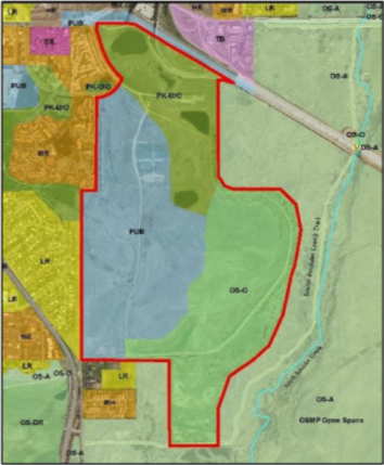
The university owns a portion of the property needed for flood mitigation. The CU South Annexation Agreement set terms between the city and university and discuss use of the 308-acre parcel for flood mitigation, open space, recreation and future university development. A total of 129-acres of the 308-acre site (shown in the blue area and labeled - “PUB” below) are anticipated for university development.

Figure: CU South Land Designations

Image
CU South Figure Land Designations

Why will the university’s future development receive 500-year flood protection while existing Boulder residences in the West Valley only receive 100-year flood protection?

The 500-year flood protection design was determined infeasible. The city, county and university agreed that no enclosed structures (like housing) on CU South be permitted within the 500-year floodplain. Any new university housing will be outside the 500-year flood plain and the existing downstream neighborhoods will be provided with 100-yr flood protection and reduced risk during a 500-yr flood event.

How does the flood mitigation project factor in climate change?

The proposed project is using the best available information and engineering practices for the flood mitigation design. This includes Colorado Dam Safety guidance for reliance of the structure in a Probable Maximum Flood (PMF). This guidance includes a seven percent increase to the PMF inflow to account for a one- degree temperature raise in the future.

Additionally, the city hired the consulting firm, Lynker Technologies, to report on current federal, state and local guidance and rules related to climate change and flood mitigation design. This report found that while agencies acknowledge the potential impacts of climate change there is minimal specific guidance on how to incorporate this into infrastructure design. As the design progresses, the project will continue to evaluate if and how voluntary measures might be incorporated into the design.

When will the city have approval from the permitting agencies to begin construction?

Formal permit applications for the flood project will be submitted when the design is 30 percent complete so that agencies have enough information to evaluate. Until that time, city staff will continue high-level discussions with permitting agencies to proactively address any anticipated issues. The 30 percent design documents are planned to be completed and can be viewed here. The timing of final permitting approvals is unknown until a formal submittal occurs with each of the regulatory agencies.

With which agencies is the city seeking permitting approval?

  • U.S. Army Corps of Engineers
  • U.S Fish and Wildlife Service
  • Federal Emergency Management Agency
  • Colorado Department of Transportation
  • Colorado State Engineer’s Office
  • City of Boulder

What is a disposal and why is it needed?

The flood project will require up to five acres of Open Space and Mountain Parks (OSMP) lands for the project. As flood mitigation is not a chartered purpose for city open space, a “disposal” process will be required to take land out of city open space protection. Any disposal of OSMP lands would comply with the provisions of Section 177 of the City Charter. City staff will continue working with the Open Space Board of Trustees (OSBT) on their environmental impact and mitigation concerns, including those about groundwater conveyance and project footprint, prior to requesting disposal consideration.

Instead of detaining water by US36, could you capture water upstream and away from sensitive OSMP lands ?

The City of Boulder has been considering alternatives for SBC floodplain mitigation since 1973 that have considered this question and arrived at the current project as the least environmentally damaging alternative. Most recently on Dec. 16, 2020, OSBT considered a detailed upstream analysis that determined such an option would involve greater environmental impacts than the 100-year project and would require significant infrastructure on city open space. Therefore, OSBT did not recommend further work on the upstream alternative presented.

While a theoretically feasible option, the upstream alternative would also require annexation because it too relies on use of property owned by the university. The city would have to evaluate flood mitigation options if an annexation were not to occur, but there are not any easily identifiable, less damaging or obvious solutions.

How will the project impact the existing environment?

The project is committed to minimizing and/or avoiding environmental and ecological impacts. South Boulder Creek is the second largest drainage route in Boulder, and this flood mitigation project has been found to have the least environmental impacts of the alternatives considered, including those to wetlands. Project design criteria includes replication of existing groundwater flow patterns to prevent upstream groundwater build up, drying up of downstream wetlands and other potential adverse impacts.

OSMP land within and surrounding the project area holds some of the highest ecological value anywhere in the Boulder Valley. The project area on OSMP property lies within the South Boulder Creek State Natural Area. This mosaic of mesic grasslands, wet meadows, and high-quality wetlands was designated in 2000 by the State of Colorado in recognition of its state-wide significance as an exceptional riparian and floodplain ecosystem. Ecological and agricultural resources contribute to an area rich in biological diversity. Some of the key resources to be avoided or mitigated for are: extensive high-quality wetlands and riparian areas, including plains cottonwood riparian forests, willow shrublands, freshwater marshes and wet meadows; tallgrass prairie communities ; extremely high densities of the threatened Preble’s Meadow Jumping Mouse and its critical habitat; and Ute ladies’ tresses orchid populations, a rare wetland plant designated as threatened under the Endangered Species Act.

What are the impacts to the wetlands?

The flood mitigation project is just beginning the 60% design and is subject to change, but the current estimate of wetland impacts is 5.9 acres of temporary impacts, 6.2 acres of permanent impacts for a total of 12.1 acres. We expect to be able to fully mitigate the impacts on the CU South property, which is currently owned by the university but will transfer to the city upon certain conditions of the annexation agreement being met.

The university will be required to comply with local, state and federal permit requirements to mitigate any wetland impacts created by its development plan.

Is there a plan in the project for restoration?

This project will follow environmental regulations to limit and mitigate impacts. This will include a significant environmental restoration component. Newly restored natural areas are expected to be added to city open space. This project includes preservation and restoration to improve the natural ecosystem, reconnect the historic floodplain, and compensate for unavoidable environmental impacts.

The existing natural resources in the project area are highly dependent on current groundwater patterns. How will the project maintain existing groundwater conditions after the project is built?

Groundwater conveyance systems are common engineering features. From an environmental perspective, replication of existing groundwater conditions is essential in preserving wetlands. The SBC flood project requires a functioning ground water conveyance system that successfully replicates existing conditions both for dam safety and environmental purposes. To do this, the project team is using existing data, and groundwater and surface water data collected since Feb. 2018 to develop a baseline groundwater model to represent existing conditions. The project will then use this model to design a groundwater conveyance system that maintains the existing conditions and will be required to work fully for as long as project features that tie into bedrock (i.e. the floodwall and detention dam) are in place. There will also be monitoring of the groundwater conditions around the project area to verify that the groundwater system is working as designed.

Why build flood detention? Why not just convey flood water in South Boulder Creek?

Boulder’s Stormwater and Flood Utility prefers a “conveyance” approach – keeping floodwater in the creek channel - to flood management where conditions allow. In situations such as South Boulder Creek south of US36 where conveyance of flood waters would increase flooding above existing conditions, detention is used as an alternative flood mitigation tool. The project will integrate environmental and aesthetic features into the overall project design as has been the city’s practice on flood utility projects.

What will happen to the existing levee?

The existing levee will be removed as part of the project. This will allow for the historic floodplain to be reconnected and construction of environmental mitigation. FEMA is the regulatory agency with jurisdiction over the levee.

Why is the city investing so much on this project?

The city does not currently have a citywide cost benefit comparison for its 16 drainageways. Each drainageway is evaluated through a lifecycle process of mapping, mitigation planning, design and construction that does not readily lend itself to a city-wide cost/benefit comparison since each drainageway is at a different point in the lifecycle and since there are many other factors that impact the viability of projects besides costs and benefits. Regardless of the selection criteria, South Boulder Creek is considered a high priority because of the identified flood risk, flood benefits from the project, damage experienced during the 2013 flood and direction from City Council.

The city is currently updating the 2004 Comprehensive Flood and Stormwater Master Plan, which will include development of prioritization criteria for future flood mitigation projects across the city.

Racial Equity Tool

The City of Boulder has an important role to play in welcoming, supporting and serving people of diverse backgrounds in our community and in government processes. While we have done valuable equity work in the past, including the creation of a diversity policy two decades ago, an inclusivity assessment conducted in 2017 showed us that our impact has been limited. The city is currently incorporating use of a Racial Equity Assessment Tool into project approach and implementation. While still relatively new, the hope is that applying the racial equity lens to projects such as this will create more equitable delivery of services.