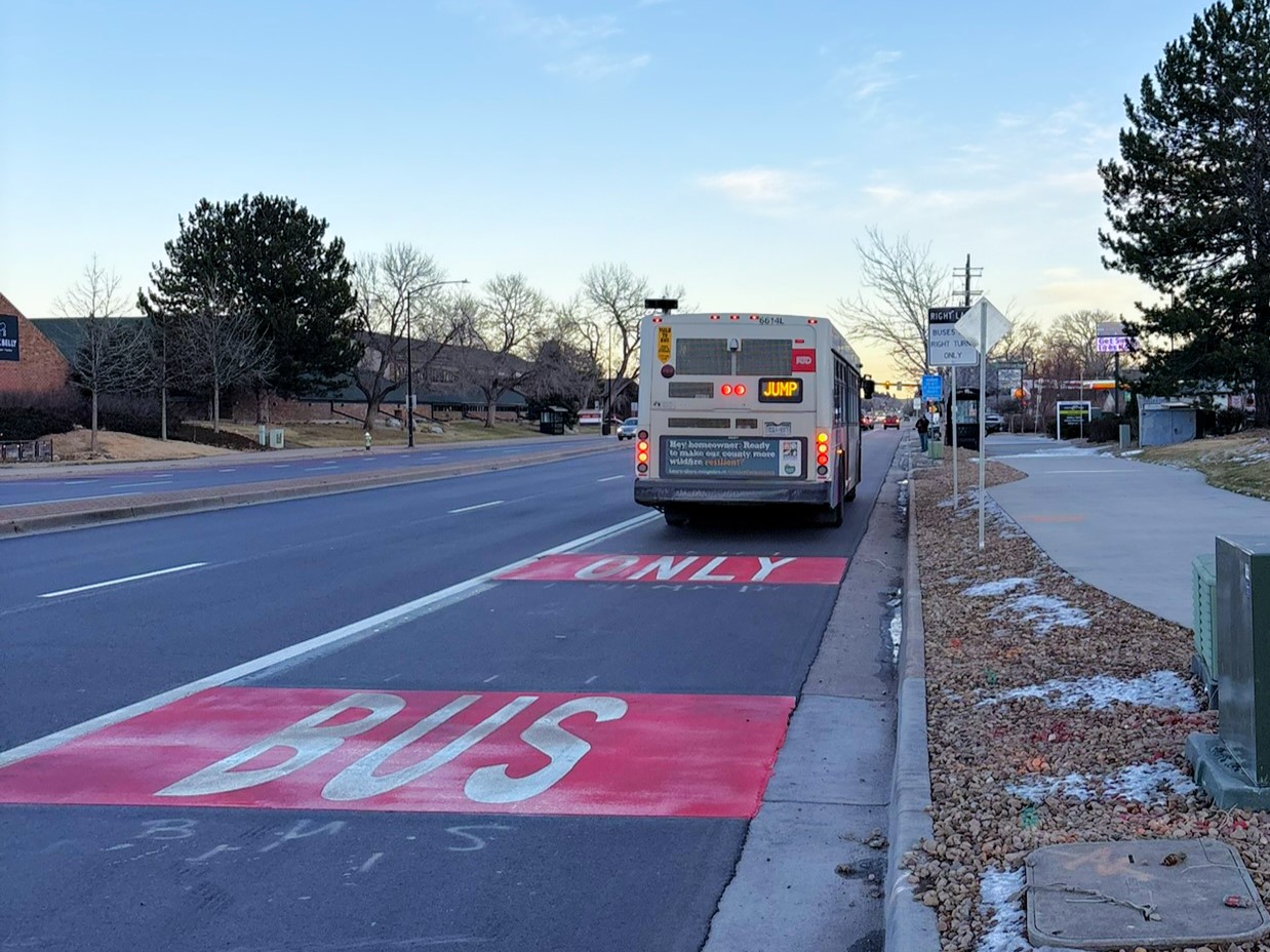
East Arapahoe Avenue, or CO 7, is one of Boulder's most heavily traveled corridors. Boulder’s vision is to support a future East Arapahoe Avenue that invests in our community’s growing travel needs for safer, more efficient travel. As more people move along this street, the city and its regional partners, including the Colorado Department of Transportation (CDOT), are taking action to ensure people have safe, reliable and convenient travel options now and into the future.

For information about repaving and construction impacts, please visit the Colorado Department of Transportation (CDOT) website.

Project Overview

CDOT will repave Arapahoe Avenue between 28th Street and Cherryvale Road for smoother, safer travel. As part of this repaving project, and in partnership with CDOT, the City of Boulder will convert underutilized right lanes to bus and turn lanes, which are curbside lanes for buses and right-turning vehicles.

The new curbside bus and turn lanes will improve travel for all by reducing vehicle conflicts with the bus, making turning right easier and safer for all travelers, and speeding up transit travel times while supporting reliable travel times for people driving.

Project Details 

Curbside bus and turn lanes offer several benefits:

  • People driving have fewer conflicts with the bus as it makes frequent stops, providing safety benefits.
  • Turning right at intersections and into driveways is easier and safer, because bus and turn lanes provide better visibility and opportunity to turn.
  • Travel is more reliable for vehicles using the general-purpose lanes, as they are no longer delayed by turning vehicles or buses.
  • Travel time for buses is faster and more reliable

Check it out in person!

While curbside bus and turn lanes will be new on Arapahoe Avenue, they’re not new to the city. Curbside bus and turn lanes have been in place in Boulder for many years on north 28th Street and more have been installed recently on Colorado Avenue. These curbside bus and turn lanes will be marked red and signed similarly to other bus and turn lanes in the city, making it easier for all travelers to see where to go.

28th and Colorado bus only lane markings
Example curbside bus lane in Boulder at 28th Street and Colorado Avenue.

Timeline 

Construction is scheduled for 2025. Installing the curbside bus and turn lane striping while CDOT is repaving the roadway avoids the city having to restripe the roadway at a later date, which would be more costly and disruptive for the community. This city and state partnership will save funds and time, minimizing impacts to community travel during construction.

Frequently Asked Questions

You can still expect reliable travel times if you drive and can expect better reliability when you take the bus.

Today, the curbside lanes are underutilized, with only 14% to 25% of through traffic using these lanes. The reason for this is simple: people driving don’t want to get stuck behind right-turning vehicles and buses.

When the curbside bus and turn lanes are installed, traffic forecast estimates find that in the morning and evening rush hours, an average vehicular trip time between 65th and 28th streets will increase by less than a minute. The project improvements effectively formalize how the street operates today with most through traffic in the center two lanes and the curbside lane being used for turning vehicles and buses.

The curbside bus and turn lanes will help improve right-turn access to businesses.

The curbside bus and turn lanes can reduce the risk of crashes by reducing conflicts between turning traffic, buses, and through vehicles.

For example, two common crash types of concern are sideswipes, which occur when right-turning vehicles enter or exit driveways and local streets, and rear-end crashes, which occur when drivers slow down as they prepare to turn and the driver behind them fails to stop.

The Bus and Turn Lane Signing and Striping Project will cost approximately $480,000 and is funded by the City of Boulder.

decorative graphic

East Arapahoe Avenue Projects 

Local and regional planning documents provide policies, objectives and actions that guide the planning, delivery and funding of city services, infrastructure and programs. This project is part of a long-term vision for redesigning Arapahoe Avenue between 28th and 63rd streets and was shaped by extensive technical analysis and community engagement.

Learn more on the East Arapahoe Projects webpage.

This section provides text alternatives to the webpage graphics. The city is in the process of making all of its websites and applications more accessible. If you would like assistance, contact the city's ADA Coordinator using the Accessibility Complaint or Request Form or by calling 720-576-2506. Please know that the city is happy to assist you and do not hesitate to reach out.

Project map long description

Project limits map on CO 7/ Arapahoe Avenue for summer 2025. Bus lane signing and striping extends from 28th to 63rd streets. Repaving extends from 28th Street to Cherryvale Road.