East Arapahoe Avenue, or CO 7, is one of Boulder's most heavily traveled corridors. Boulder’s vision is to support a future East Arapahoe Avenue that invests in our community’s growing travel needs for safer, more efficient travel. As more people move along this street, the city and its regional partners are taking action to ensure people have safe, reliable and convenient travel options now and into the future.
Moving People Safely
Projects
It will take time to work toward better travel options for the greater number of people who will be traveling, working and living along the corridor. The city and our regional partners will work toward this vision of improved travel for all through a phased approach of smaller projects over many years.
CO 7 Multimodal Corridor Improvements
The CO 7 Multimodal Corridor from Brighton to Boulder is a set of projects with the vision of a safer and more connected corridor for all travelers. Work is coordinated between the city and agencies like the Regional Transportation District (RTD) and the Colorado Department of Transportation (CDOT). Planned improvements include Bus Rapid Transit (BRT) service, a regional bikeway, bus, bike and pedestrian connections, and first- and final-mile connections to the bus from people's destinations, such as with scooters, bikes, ride shares or other transportation modes. For the full regional corridor project, visit the CDOT project webpage. The City of Boulder segments listed below are currently funded:
CDOT, in partnership with the city, completed the preliminary design for the CO 7 Corridor Segment A between 28th and 63rd streets in summer 2024.
Informed by the preliminary design phase, completed in 2024, we will advance the 28th Street to Foothills Parkway segment to final design.
Informed by the final design from 28th Street to Foothills Parkway, we will construct multimodal safety improvements between 28th Street and 38th Street. This segment is funded through federal grant funds and city funds approved in the Capital Improvements Program.
CO 7 Transit Starter Service: Brighton to Boulder Flyer
Boulder County received a Federal Transit Administration grant to implement a transit starter service program from Boulder to Brighton. The route is set to include around 10 stations over 26.6 miles, serving communities within Boulder, Broomfield, and Adams counties and will connect with other regional and interregional transit routes. Operations will begin in late summer/early fall 2026. Visit CDOT's website for more information on the CO 7 Multimodal Corridor Planning Initiatives.
Completed Projects
Vision
These projects and vision are part of the East Arapahoe Transportation Plan (EATP), a long-range plan that will consider a number of potential transportation improvements within the East Arapahoe corridor. This plan aims to respond to changing travel needs along this corridor, which has become one of Boulder’s largest employment centers and with many calling this area home.
The 2040 vision for East Arapahoe is to create a Complete Street. A complete street is one where all users are considered and safely accommodated. Regional Bus Rapid Transit (BRT) service connects Boulder to I-25 and Brighton via State Highway 7 and East Arapahoe and includes the following features:
- Two general-purpose traffic lanes are maintained in each direction.
- Curbside business access and bus and turn lanes accommodate local and regional transit, right-turning vehicles, HOVs and new technologies such as shared autonomous/connected vehicles.
- Raised protected bike lanes with a multi-use path create safe, comfortable places for people to walk and bike.
- Amenity zones enhance the streetscape and public realm.
The plan also aligns with Boulder’s Transportation Master Plan (TMP), Sustainability & Resilience Framework, and Climate Commitment.
CO 7 Vision

1 of 3

2 of 3

3 of 3


View the Full Plan
As members of the CWG, we feel that this was a credible process that accounted for both a technically rigorous analysis and extensive public input.
- East Arapahoe Transportation Plan Community Working Group, 2018 Statement of FindingsThe EATP was shaped by extensive technical analysis and community engagement. Learn more by viewing the full plan:
Related Plans
Local and regional planning documents provide policies, objectives and actions that guide the planning, delivery and funding of city services, infrastructure and programs.
Frequently Asked Questions
Learn more about the East Arapahoe Transportation Plan.
View the proposed preliminary designs on the CDOT website.
Travel is only projected to worsen if we don't plan proactively. Projections show increasing congestion, growing safety concerns, and limited travel choices that aren't up to standards for people walking, biking and using transit. We expect traffic to increase by as much as 20% with growth in surrounding communities and Boulder’s position as a regional employment center. We need to provide better travel options for commuters and for the greater number of people working and living along the corridor today and in the future.
Our policy is to implement cost-effective roadway improvements that increase the efficiency of the existing transportation system. This is a long-term vision. Work will likely be completed in stages over the next 10+ years, through multiple sources of funding: whether they be local, regional, state, federal or private sources. Some projects have already been fully funded from these various sources, and future projects will follow a similar process.
Work will make travel safer for all transportation modes, including through targeted improvements at high-crash locations and for the most vulnerable travelers, such as people walking and biking. These projects support Boulder's actions to achieve Vision Zero – the community goal to eliminate serious injuries and fatalities resulting from traffic crashes.
BRT is a more convenient, reliable and desirable travel option. Future BRT service between Boulder and Brighton is projected to:
Have dedicated lanes and signal priority to speed trips. Each of the future BRT options will reduce transit travel times in the corridor to within 1 to 3 minutes of eastbound auto travel during peak hours in the afternoon.
Have fewer stops than the existing JUMP service.
Improve options for people to travel the first and last mile.
Reduce time spent at bus stops.
More than triple ridership, from an estimated 2,400 weekday boardings today to between 7,000 and 10,000 boardings.
Today, Arapahoe Avenue currently provides the fastest travel route for destinations in the corridor. A detailed study of existing travel patterns, including alternative east-west travel routes, showed that diverting through nearby neighborhoods does not save driving time. People are typically good at finding the quickest travel paths. This plan aims to maintain efficient traffic flow and the competitive travel time advantage that Arapahoe Avenue already has, discouraging east-west travelers from using side streets. With these improvements, future travel on Arapahoe Avenue is projected to be shorter during the morning and afternoon peak travel times than in an alternative where we don’t build any changes.
We’re making progress on community and regional climate goals, but falling short of community goals. Boulder has set a strong goal for reducing single-occupancy vehicle (SOV) car trips by 2035, and we are not on pace to meet that goal. More progress is needed and we must also continue to address regional travel, particularly opportunities to improve options for non-resident employees.
This project supports improving travel options to reduce SOV travel and related emissions.
This work can take up to 3700 cars off the road per day. That’s equivalent to all the parking garages in Downtown Boulder.
Vehicle miles traveled (VMT) is expected to increase by 5% or less – a significant difference compared to a nearly 18% increase if we don't act.
As East Arapahoe Avenue and surrounding neighborhoods become more of a destination, community and travelers of all modes are looking for a more comfortable experience. The plan dedicates a percentage of public right-of-way to these streetscape features, such as medians, landscaping, amenity areas, and pedestrian and bicycle infrastructure – with features that are scaled for people and create a place that is attractive to both travel through and spend time in.
The first and last miles to bus stops can be challenging, especially in suburban communities. If walking or biking to a transit stop is too far, or connections are limited, travelers tend to avoid taking the bus.
By improving walking, biking and transit mobility options in the area to help people travel comfortably, conveniently and safely to bus stops, we aim to reduce these problems. The plan considers how to bridge these first and last-mile gaps with solutions like bike sharing, covered and secure bike parking, shuttle and car share services, and on-demand transportation services such as ride-sharing or ride-hailing.
Yes. A community working group provided input to city staff during the planning process. The working group's feedback helped staff explore future transportation options that serve the varied needs of the community. There was also extensive community engagement with the general community from November of 2015 to May of 2018 to consider major themes, ideas, concerns and suggestions raised by members of the public through a series of engagement activities. The full PDF report is available on request. You can also view the CWG's Statement of Findings, released Feb. 16, 2018.
Web Accessibility
This section provides text alternatives to the webpage graphics. The city is in the process of making all of its websites and applications more accessible. If you would like assistance, contact the city's ADA Coordinator using the Accessibility Complaint or Request Form or by calling 720-576-2506. Please know that the city is happy to assist you and do not hesitate to reach out.
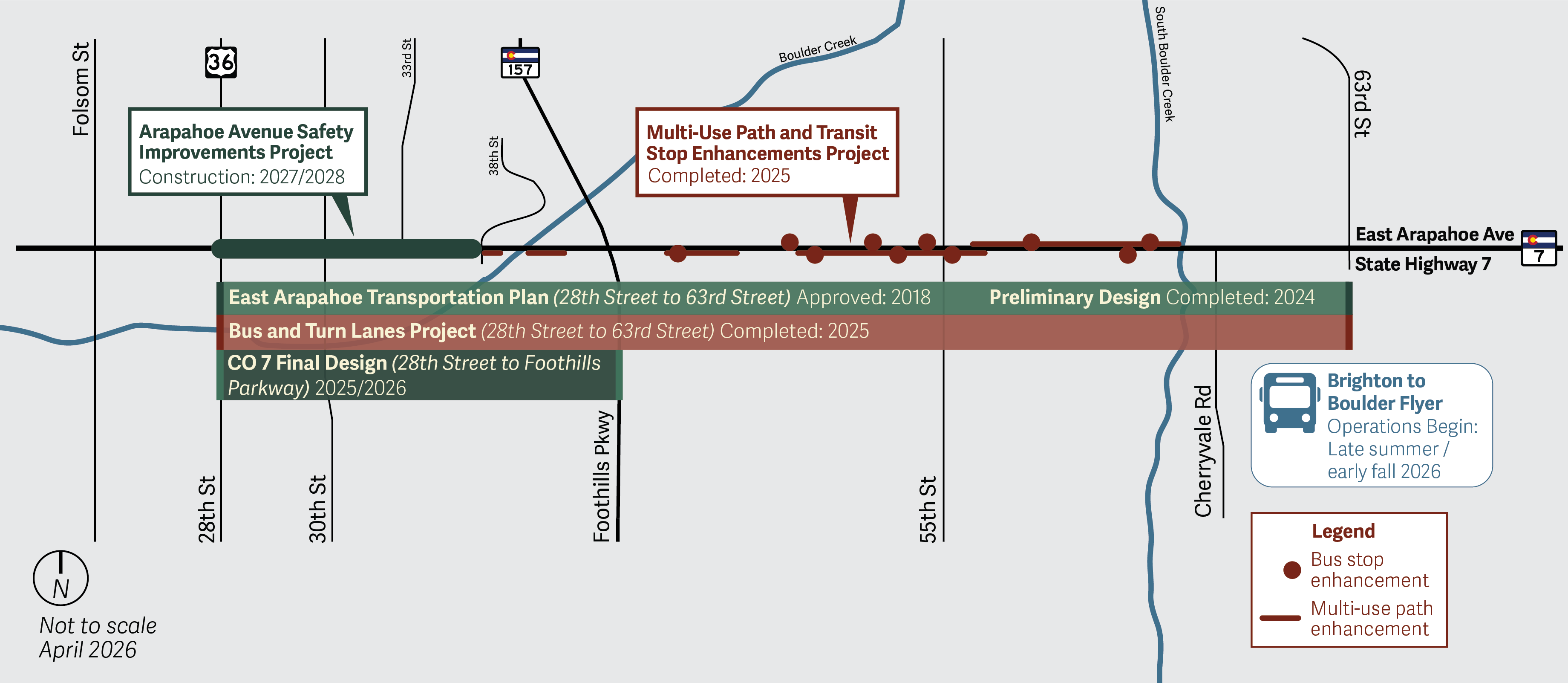
Projects Map Long Description
A map of the East Arapahoe Ave corridor from Folsom Street out past 63rd Street that displays various projects and their status. The East Arapahoe Transportation Plan from 28th Street to 63rd Street was approved in 2018 and preliminary design was completed in 2024. Final design for CO 7 (28th Street to Foothills Parkway) is underway in 2025-2026. The Bus and Turn Lanes project from 28th Street to 63rd Street was completed in 2025. Construction for the Arapahoe Avenue Safety Improvements Project, from 28th Street to 38th Street, is expected in 2027/2028. The Multi-Use Path and Transit Stop Enhancements Project from 38th/Marine Street to Cherryvale Road was completed in 2025. The Brighton to Boulder Flyer, a regional bus service, will begin operations in late summer or early fall of 2026.
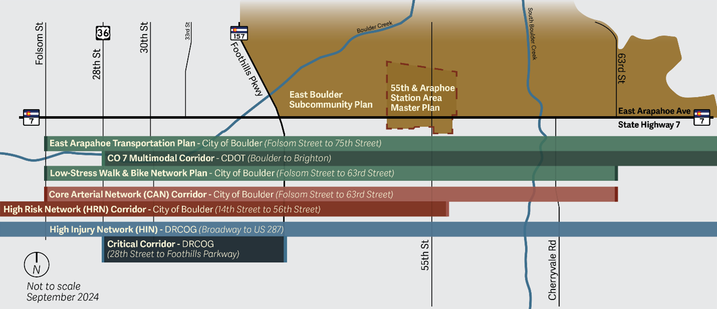
Comprehensive Map Long Description
A map showing the East Arapahoe corridor from Folsom Street out past 63rd Street and that includes the plans and policies that guide projects on this corridor. These plans and policies are: the East Arapahoe Transportation Plan (Folsom Street to 75th Street, by the City of Boulder), the CO 7 Multimodal Corridor (Boulder to Brighton, by the Colorado Department of Transportation), the Low-Stress Walk & Bike Network Plan (Folsom St to 63rd St, by the City of Boulder), the East Boulder Subcommunity Plan and the 55th and Arapahoe Station Area Master Plan. East Arapahoe is also a City of Boulder Core Arterial Network (CAN) Corridor (from Folsom St to 63rd), a City of Boulder High Risk Network (HRN) Corridor (from 14th to 56th St), a Denver Regional Council of Governments (DRCOG) Critical Corridor (from 28th Street to Foothills Parkway), and it lies on the DRCOG High Injury Network (Broadway to US 287).
BRT Station Conceptual Rendering Long Description
A rendering of a BRT station design looking northeast at Arapahoe Avenue and 38th Street, including a separated multi-use path and bike lane, BRT signage, BRT station and amenities, BAT lane and general purpose lane
Intersection Conceptual Rendering Long Description
Rendering looking from the multi-use path towards the protected bike and pedestrian intersection. The view is standing on the multi-use path looking northwest at Arapahoe Avenue and 38th Street. There is a bike lane, protected intersection, multi-use path including a separator, amenity zone, BAT lane and general purpose lane.
Roadway and Intersection Conceptual Rendering Long Description
A rendering view of the entire roadway cross-section. This is a bird’s eye view looking northeast at the intersection of Arapahoe Avenue and 38th Street. The BAT lanes, BRT stations, travel lanes, and protected bike and pedestrian intersections are all fully visible.
Recommended Alternative Typical Long Description
Overall Typical
The conceptual graphic of a typical section of the future road shows several transportation features for different modes of travel. These include: Multi-use paths which may be used by both people walking and biking. Between the multi-use paths and the bike lanes are amenity zones that are used both as landscaping buffers and flexible spaces that may accommodate lighting, seating, public art, trash receptacles, bike parking, wayfinding signage, and transit facilities. Next to the amenity zones are the raised protected bike lanes, which are separated from the roadway by either a narrow paved buffer or a wide amenity zone with street trees. This configuration will likely vary by location and be refined in a later design phase. Next to the bike lanes are transit stations, which include shelters and seating, lighting, real-time transit arrival information, off-board fare payment, level boarding, wayfinding signage and art. Next to the bike lanes are also the Business Access and Transit (BAT) lanes, also known as bus and turn lanes. These curbside lanes allow a combination of Bus Rapid Transit (BRT), local transit, High Occupancy Vehicles (HOV), right-turning vehicles, and new technologies such as shared autonomous/connected vehicles. Then there are General Purpose Lanes, with four lanes in total or two in either direction, maintained for most of the corridor.
Pedestrian and Bicycle Facility Options
The graphic also includes Pedestrian and Bicycle Facility Options, with two design options that are feasible and will vary by location. The configuration will be refined in a later design phase. Design Option One: a narrow paved buffer separates the protected bike lane from the roadway, and a wide amenity zone with street trees is located between the protected bike lane and the multi-use path. Design Option 2: A wide amenity zone with street trees separates the protected bike lane from the roadway, and a narrower amenity zone is located between the protected bike lane and the multi-use path.