There will be 24-hour lane closures on 28th Street between Pearl Street and Iris Avenue through July. At least one lane will remain open in each direction. Alternate routes are advised. View the suggested detour on Cone Zones.
Broadway Construction
Construction activities began this spring at the Broadway and Regent Drive Intersection and will proceed to the Table Mesa Drive intersection in late summer/early fall. Expect daily vehicle lane closures, impacts to bus stops, and detours for biking and walking. View construction-free routes on the project webpage and find construction updates on Cone Zones.
Baseline Construction
Phase 2 work is underway. Construction focuses on furthering the improvements started in Phase 1, using a $3.2 million grant.
There are significant impacts to Baseline Road at 30th Street. Visit the project webpage for the Construction-Free Routes Map.
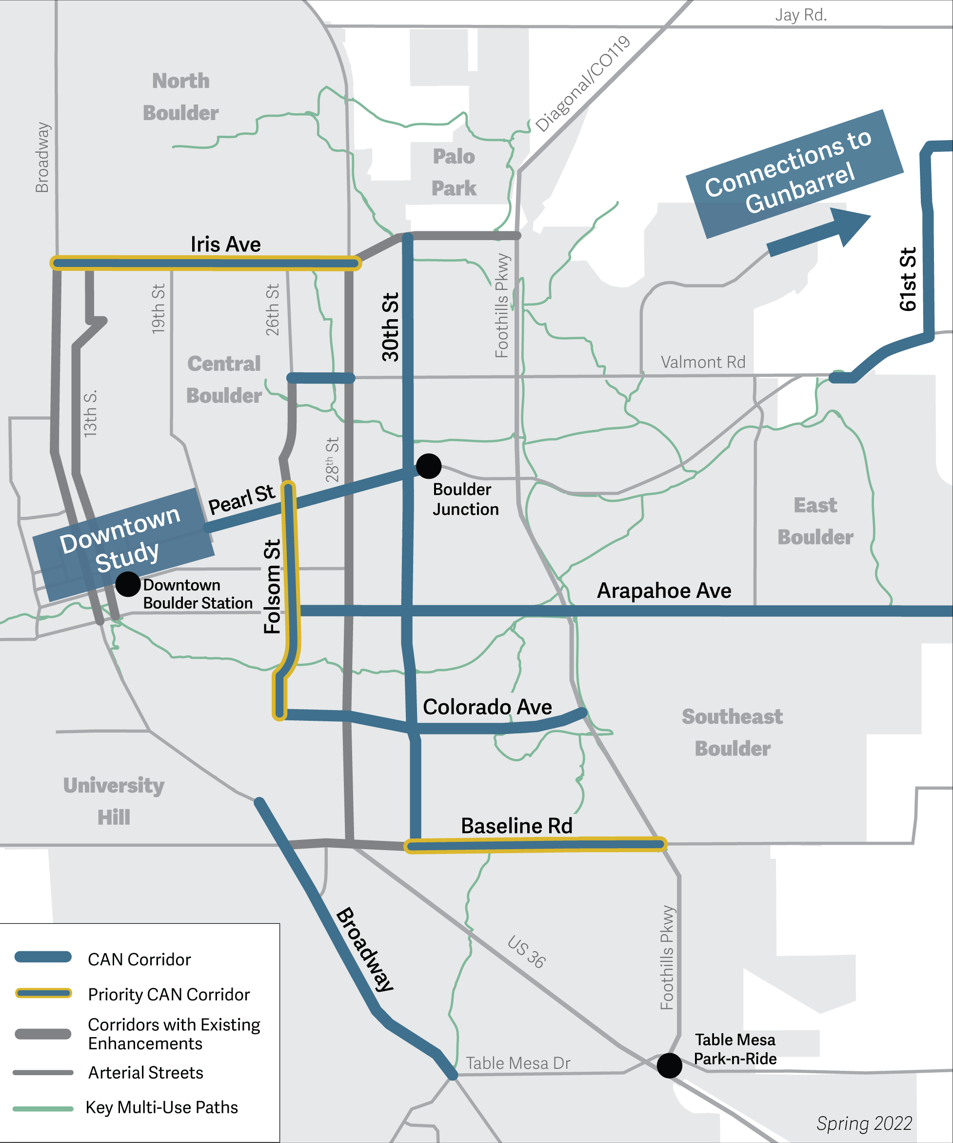
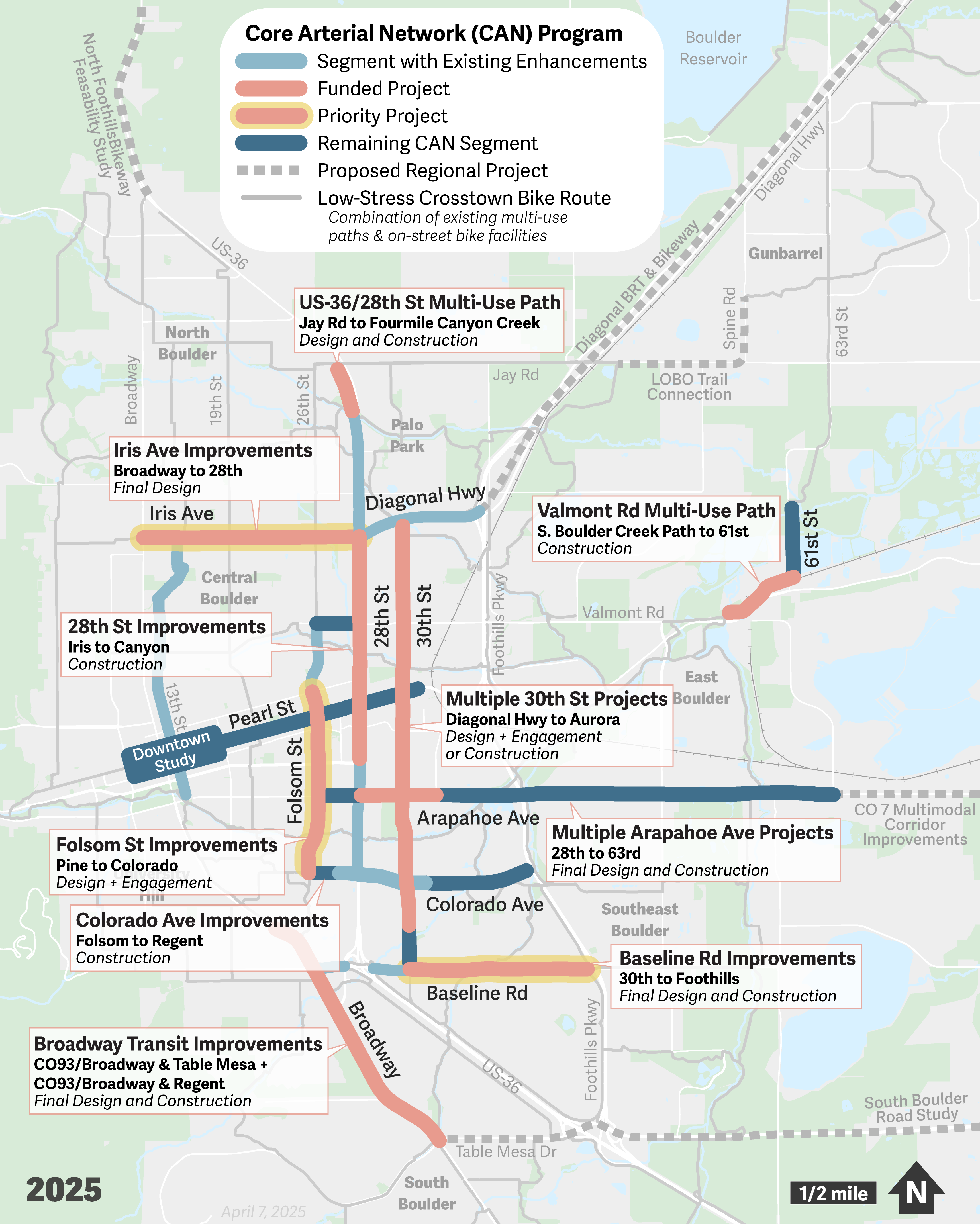
The Core Arterial Network (CAN) is the connected system of protected bicycle lanes, intersection enhancements, pedestrian facilities and transit facility upgrades that will help reduce the potential for severe crashes and make it more comfortable and convenient for people to get where they need to go along Boulder’s main corridors.
The CAN will help us organize our arterial streets to better serve people walking, bicycling, taking the bus and driving
The city will focus its efforts on 13 individual corridors over the next several years. Explore the projects in the map below.
The City of Boulder has been working for decades to create a safe, equitable, and reliable mobility system that offers travel choices and supports achieving our climate goals (2019 Transportation Master Plan, Boulder Valley Comprehensive Plan). As a result, we see significant numbers of people walking, bicycling, scooting and taking transit as they move about or travel in and out of the city. Although we have made great progress, more work remains to be done along our high-traffic arterial streets, which often have higher traffic volumes and speeds compared to other streets in the city. Findings from the Vision Zero Boulder: 2022 Safe Streets Report (SSR) show that 67% of traffic crashes resulting in serious injury or fatality occur on arterials.
We believe no one should be killed or seriously injured in traffic crashes on our streets. Moving about Boulder should be safe, no matter how you get around.
In response, the city is focusing its investments and resources to design and construct improvements on the Core Arterial Network (CAN). The CAN is the connected system of protected bicycle lanes, intersection enhancements, pedestrian facilities, and transit facility upgrades that will help reduce the potential for severe crashes and make it more comfortable and convenient for people to get where they need to go along Boulder’s main corridors.
A Boulder Priority
In January 2022, the Boulder City Council, in partnership with the Transportation Advisory Board (TAB), elevated work on the CAN as one of its 10 priorities for city department efforts. Since then, staff have made significant progress on the CAN initiative through successful grant applications and through planning, design, and construction of improvements to CAN corridors. City Council also reaffirmed its commitment to Vision Zero in December 2024.
Why is it important to focus on Boulder’s core arterial streets?
We know that a majority (67%) of traffic crashes that result in serious injury or fatality occur on Boulder’s arterial streets. As a Vison Zero city, we believe no one should be killed or seriously injured on our streets. In addition to the devastating impact of severe crashes on people’s lives, the Safe Streets Report estimates the societal cost of serious injury and fatal crashes in Boulder between 2018-2020 alone at $100 million.
In addition to addressing the human costs of these crashes, the CAN will also help Boulder make progress toward its climate goals. With many local and regional transit service options and more than 300 miles of bikeways, including 73 miles of multi-use paths and nearly 90 bicycle and pedestrian underpasses, Boulder has an extensive network of multimodal infrastructure that makes it easier to choose non-vehicular forms of travel and reduce greenhouse gas emissions. The CAN will enhance connections between these existing facilities and the places people live and work and their other daily community destinations.
What are we working on?
Boulder City Council identified 13 individual corridors where the city will focus its efforts over the next several years. Projects along these streets will enhance connectivity along the Core Arterial Network – amplifying previous investments and ensuring a predictable, safe journey between where people live and work and major destinations, such as schools, parks, grocery stores, and shopping, to name a few. Many projects are already underway to improve arterial safety and others will be initiated over the next 3-5 years.
Phase 1 used local dollars and leveraged planned pavement resurfacing as part of the city’s 2023 Pavement Management Program (PMP) to gain the safety benefits of strategic, prioritized location improvements now while the city awaited the distribution of DRCOG 2022-2025 Transportation Improvement Program (TIP) funds in the first quarter of 2024.
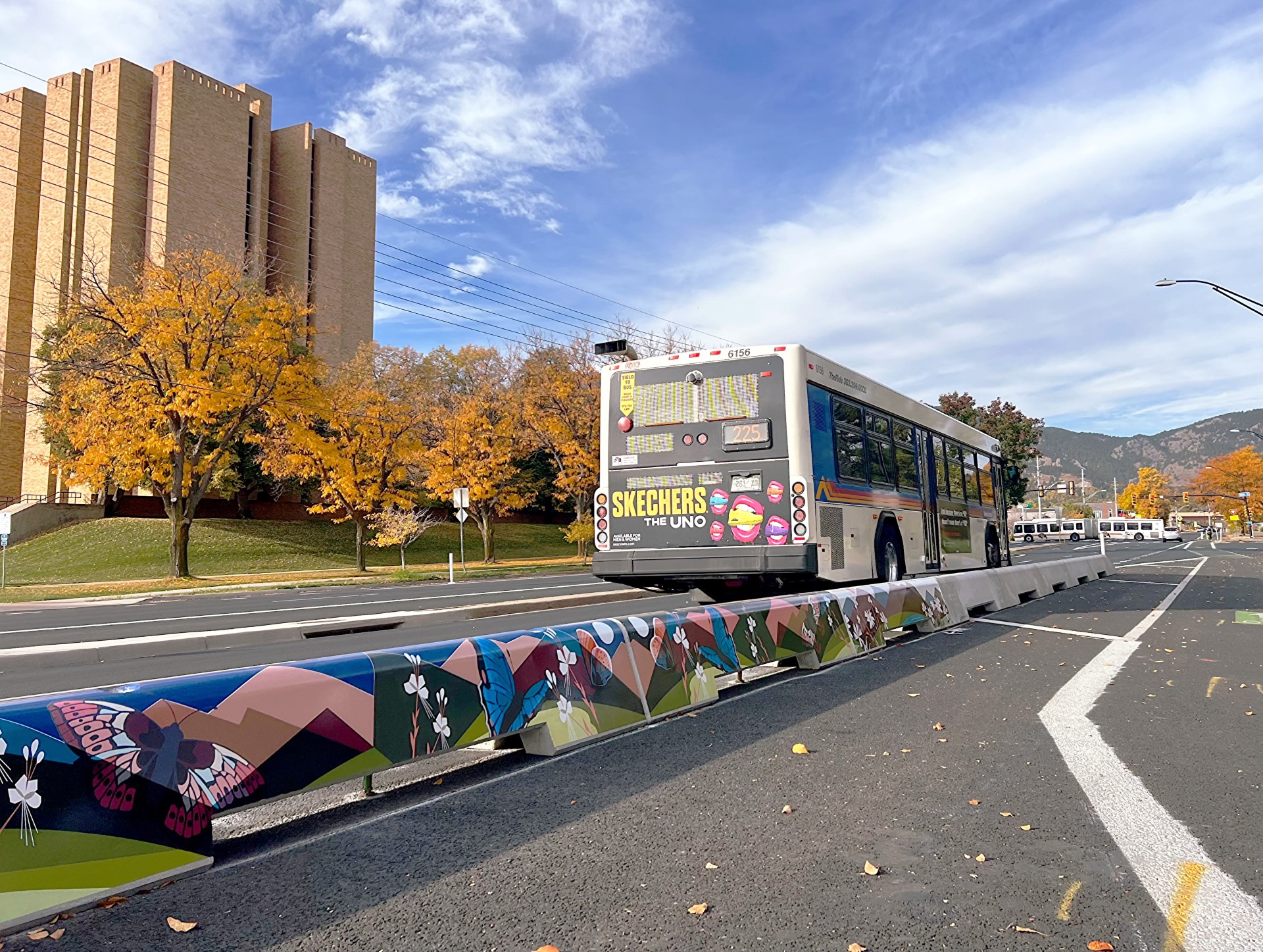
Phase 2 planning and design began after we received $3.2 million in TIP funds in 2024. Phase 2 will make permanent the interim protected intersections installed at Baseline Road and Mohawk Avenue, complete transit speed and reliability improvements from 30th Street to Foothills Parkway for this important local and regional transit corridor, and add a new protected intersection at the Baseline Road and 30th Street intersection.
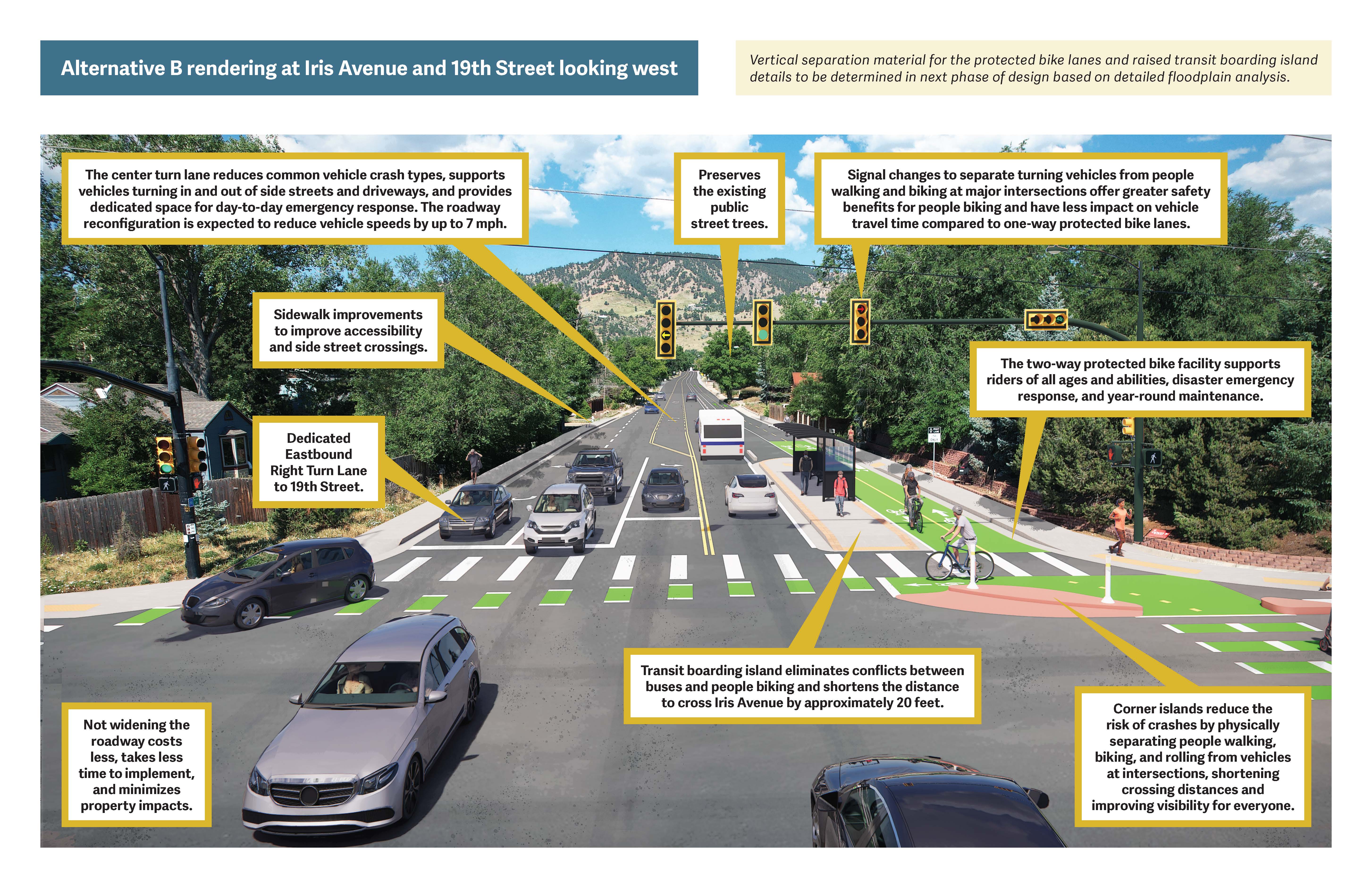
From summer 2023 to fall 2024, staff consulted plans, federal guidance and community input to identify important safety improvements for Iris Avenue between 28th Street and Broadway. The project used the city’s formal review process, the Community and Environmental Assessment Process (or CEAP), to evaluate and identify a recommended conceptual design. The CEAP evaluation and recommended conceptual design were unanimously recommended by the Transportation Advisory Board in August 2024 and unanimously approved by City Council at its Sept. 19, 2024 meeting.
Final design of the approved conceptual design began in January 2025 and will be completed in 2026. The final design will be constructed as funding is secured in the future.
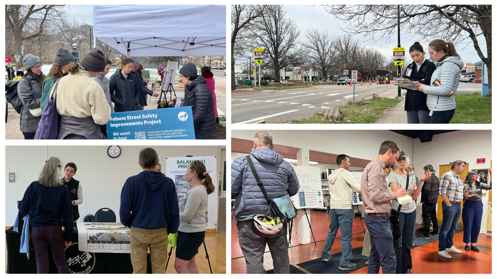
Folsom Street from Pine Street to Colorado Avenue is an important north-south corridor in central Boulder. As a key city street, Folsom Street connects residents, office spaces, restaurants, shops, grocery stores, parks and CU Boulder Main Campus to each other and the city’s transportation network for walking, bicycling, driving, and taking local and regional transit.
Staff began engagement for the Folsom Street priority corridor in December 2024 and community engagement, data analysis and design resulted in three conceptual design alternatives that were evaluated using the city’s formal review process: the Community and Environmental Assessment Process, or CEAP. TAB recommended City Council approval of the CEAP evaluation and recommended alternative in the summer of 2025, and council provided their approval in August 2025.Final design and implementation will begin once funding is available.
Future design and community engagement on CAN corridors include:
Downtown Mobility Study
How does the CAN relate to other adopted plans?
The focus on the Core Arterial Network provides a clear path forward for improvements to these streets, many of which have already been identified in the city’s adopted transportation plans such as the 2019 Transportation Master Plan and Low-Stress Walk and Bike Network Plan. Concentrating the city’s resources and pursuing grant funding for these projects will also address the goals of overarching city plans like the Boulder Valley Comprehensive Plan and Climate Action Plan. The CAN also supports the city's Vision Zero goal of ending all serious and fatal injury crashes.