A safer Baseline for a thriving community

This project will create safer conditions for walking, bicycling and driving on Baseline Road while enhancing connections to popular community destinations.

Completion Date
2023 (Phase 1) | 2026 (Phase 2)
Current Phase
Build

Project Overview

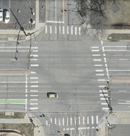
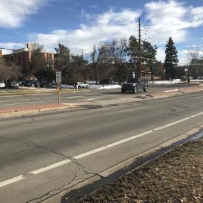
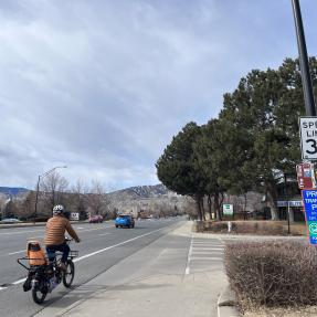
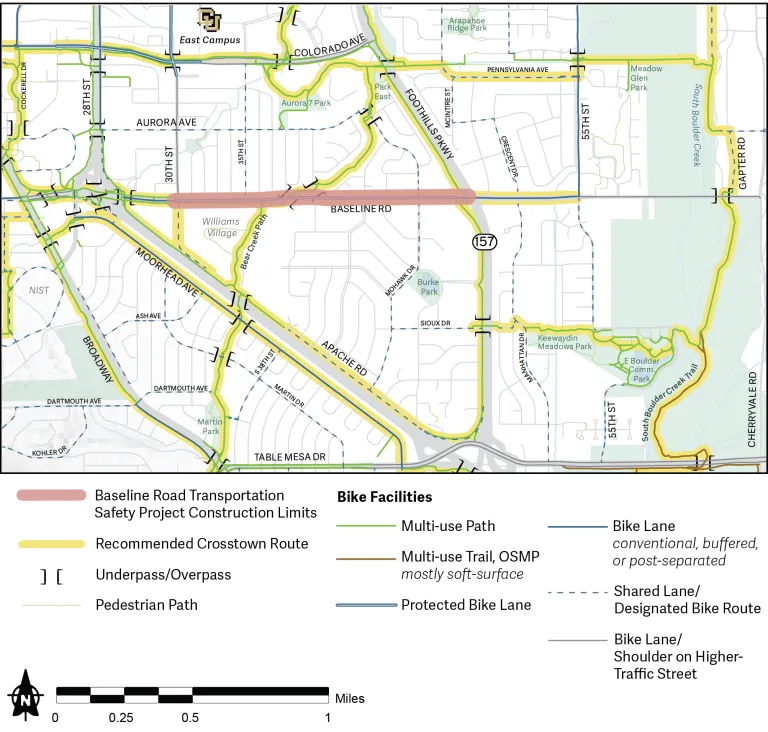
The Baseline Road Transportation Safety Project is a multi-year project focused on improving safety along Baseline Road, one of the city’s most-traveled corridors. This section of Baseline Road — from 30th Street to Foothills Parkway — is home to many key community destinations and services, including affordable housing, grocery stores, shops, health centers, and student housing for the University of Colorado Boulder.

According to the city's 2022 Safe Streets Report, this is one of the top 10 crash locations for people walking and bicycling in the city. It was identified in the Denver Regional Council of Government's Regional High Injury Network, the 9% of roads in the region where the majority of serious injury and fatal crashes occur. The regional High-Injury Network also identifies critical corridors, the highest-density corridors for serious injury and fatal crashes. This segment of Baseline Road is also a critical corridor.

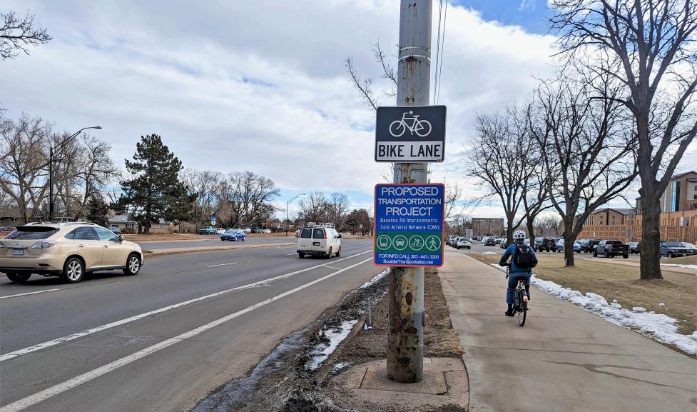
Following findings that show that 67% of traffic crashes resulting in serious injury or fatality occur on arterial streets, City Council prioritized design improvements to 13 key streets as part of Boulder's Core Arterial Network (CAN) initiative. This project is one of three priority corridor projects on the CAN.

Project Details

Phase 2 (2024 – 2026)

Construction of Phase 2 begins in spring 2026. Phase 2 focuses on furthering the improvements started in Phase 1 using newly distributed federal funds. The $3.2 million grant will support the comprehensive implementation of multimodal, capital-intensive improvements, such as:

  • Better protecting the bike lane and completing the intersection protection provided with roadway repaving in Phase 1.
  • Additional pedestrian and protected intersection enhancements.
  • Transit efficiency improvements.

Timeline

  • Spring 2024: Community questionnaire and interactive map inform conceptual design.
  • Fall 2024: In-person and virtual open houses share conceptual design and gathers community feedback to inform final design.
  • Winter to Summer 2025: Final design.
  • Spring 2026: Construction begins and will last about 6-9 months, pending weather and contractor availability.

Final Design

The final design focuses on reducing vehicle speeds and improving safety at intersections where most serious injury and fatal crashes occur or are more likely to occur in the future. Community engagement during 2024 helped the project team prioritize these design elements, which include:

  • Reduced speed limit to a consistent 35 mph along the entire corridor.
  • Replacement of flexible posts and paint-buffered intersections with permanent concrete at side streets: 32nd Street, 35th Street, Meadowbrook Drive, and Inca Parkway.
  • Modified designs to create designated spaces for outbound and inbound vehicles at Meadowbrook Drive, Inca Parkway, and Laguna Place to respond to feedback received after Phase 1.
  • A new signalized pedestrian crossing between 33rd and 34th streets to connect people walking and biking between the north and south sides of Baseline Road.
  • Improved transit efficiency and accessibility with floating bus stops that include seating and Americans with Disabilities Act (ADA) compliant boarding areas. Floating bus stops improve safety by removing conflicts between bikes and buses at bus stops.
  • A new bus shelter at the westbound stop on Mohawk Drive.
  • Improved bike lane protection at bus stops with floating concrete island bus stops, which close gaps in protection from Phase 1.
  • Concrete tall curbs are shifted to provide maximum safety and comfort benefits while complying with floodplain requirements.
  • Protected signalized intersection at Mohawk Drive:
    • The interim protected intersection becomes permanent and is simplified with less visual clutter for ease of navigation.
    • Bus stops at The Meadows and Mohawk Drive are consolidated to one floating stop on the east side of the Mohawk Drive intersection to simplify eastbound traffic patterns and improve transit efficiency.
    • Bike lanes are modified through the intersection for smoother travel.
    • Truck aprons, a mountable area on the outside of corner islands, provide more turning space for right turns.
    • Pedestrian refuge islands reduce crossing distances and the length of exposure to vehicle lanes for people walking.
    • Combined right and through vehicle lane on northbound Mohawk Drive allows better protection of pedestrians and bicyclists on the southeast corner. This vehicle lane reconfiguration better accommodates northbound right-turning movements and reduces the conflict with southbound left-turning vehicles.
  • Protected signalized intersection at 30th Street:
    • Transit priority improvements for the CU Boulder Buff Bus are implemented on northbound 30th Street with the addition of a dedicated bus lane.
    • The northeast corner right-turn slip lane is repurposed for a protected corner and improved sidewalk and bike lane connections to the north.

The community also prioritized continuous bike lane protection, which is not included in the final design due to budgetary constraints. Though Phase 2 does not provide this continuous protection, compared to Phase 1, protection will still grow by 64%. Phase 2 takes the roughly 3,550 linear feet of existing protection and expands it to over 5,850 feet, primarily by adding floating bus stops and concrete-protected intersections. Because no new tall curbs could be funded in Phase 2, the remaining segments of the corridor will be entirely post-separated.

We will continue to seek additional funding to implement these community priorities in the future.

Community Engagement

We held Phase 1 community engagement in 2022 to understand how the community experienced Baseline Road and what the major obstacles to safe travel were. Work was completed in 2023 and we followed up with a questionnaire to understand the community’s satisfaction with the interim design elements.

We returned to the community with conceptual designs in spring and fall of 2024 to kick off Phase 2 engagement and gather feedback informing final designs.

The community’s top three priorities are: protected bike lanes, mid-block crossings, and protected intersection improvements.

  • Comments about reorganized intersections:
    • Drivers report right turns feel too tight.
    • Concerns about reorganized intersections and the complexity of the design elements such as flexible delineator posts, tall curbs, tall curb art, striping, and signing.
    • Rear-end concerns when turning off Baseline Road onto side streets.
    • Right-turn conflict concerns at Mohawk between bicyclists traveling north or south through the intersection or between right-turning and left-turning vehicles.
    • Mohawk Drive concerns about the no right turn on red restriction; perception that it could cause traffic backups, cut through traffic through Safeway parking lot, aggressive driving, conflicts between north/southbound bikes and pedestrians and right-turning vehicles.
    • Visual complexity of new design elements and sight triangle concernsat side streets.
  • Traffic congestion concerns with current design and as a potential result of floating bus stop installation.
  • Support for a mid-block crossing between 33rd and 34th streets and the desire for another mid-block crossing between the Bear Creek Path underpass and Mohawk Drive near Inca Parkway or Meadowbrook Drive.
  • Vehicle speed concerns.
  • Desire for greater education of university students about existing and new design elements.   
  • Support for the project and for physical protection between people biking/walking and vehicles.

Once people had a chance to try traveling on the street after the installation of improvements from Phase 1, we opened an online questionnaire, which recorded 180 responses from people who walk, bike, take the bus, and drive along and across Baseline Road. The questionnaire asked to what extent the Phase 1 changes made you feel safer, more comfortable, and better connected.

General feedback we heard:

  • The most appreciated improvements, regardless of how respondents travel, were:
  • pavement resurfacing, green bike lane markings, new crosswalks, the widened bike lane and bike lane buffer, and tall curbs. In general, respondents who bike indicated feeling safer, more comfortable, and better connected.

Most concerns and questions were about

  • Reorganized intersections — the extension of the curb and tightening turns to shorten crosswalk distances for people walking and biking.
  • Narrowed vehicle lanes.
  • Flexible delineator posts, or white flex posts.

We also heard community desires for upcoming Phase 2 improvements:

  • Improving safety by removing conflicts between bikes and buses at bus stops, such as when a bus crosses into the bike lane to stop for passengers.
  • Continuing efforts to discourage people driving from using the bike lane as a vehicle turning or travel lane.
  • Installing additional tall curbs to complete bike lane protection.
  • Installing more and improved crossings.
  • Improving visibility, wayfinding, and access, particularly at intersections.

Phase 1 is complete. Phase 1 began in August of 2022 and took advantage of pre-scheduled pavement resurfacing as part of our Pavement Management Program (PMP). This phase focused on making strategic improvements from 28th Street to Foothills Parkway with city funds. These improvements were informed by what we heard from the community in fall 2022 and included:

  • Narrowed and restriped travel lanes, a safety design that has been shown in studies to reduce vehicle speeds.
  • Repaved and restriped Mohawk Drive from Baseline Road to Pawnee Drive to better accommodate all travelers to and from Baseline.
  • Reorganized intersections by extending the curb and tightening turn radii to shorten pedestrian and bicycle crossing distances. This expanded the pedestrian area and continues to slow vehicles and improve driver sightlines.
  • Provided physical protection to improve comfort and safety at strategic, prioritized parts of the bike lane.
  • Added “hardening” or physical protection through concrete tall curbs in strategic areas to replace the existing striped buffers or flexible delineator posts. The city’s tall curbs also display art from a local artist, Talia Swartz Parsell, commissioned through the Community Vitality Office of Arts and Culture muralist roster.
  • Installed flexible delineator posts and added striped buffers to separate the bike lane.
  • Added new crosswalks at the Inca Parkway intersection.
  • Added green bike lane markings at intersections.
  • Consolidated bus stops to reduce conflicts between bikes and buses and to improve ADA accessibility and pedestrian access to remaining stops.
Mohawk at Baseline intersection aerial

Existing Conditions

Check out the slideshow to see Baseline Road now that Phase 1 is complete.

Words that say "A safer Baseline for a thriving community"

Other projects on Baseline Road

Additional changes are coming to Baseline Road as part of other ongoing projects.

Signal reconstruction projects will or have taken place at two intersections: Baseline Road at Mohawk Drive and at Baseline Road and Canyon Creek.

Regular, scheduled pavement maintenance to repaved Baseline Road between east of Foothills Parkway to just west of Gapter Road in 2024. Mobility enhancements were coordinated with this scheduled repaving as a cost-effective and efficient way to improve safety for everyone walking, biking, rolling, driving and taking transit. For more information, visit the Pavement Management Program webpage.

The city was awarded over $700,000 in to improve pedestrian and bicycle infrastructure near Manhattan Middle School. Learn more about Safe Routes to School: Manhattan Middle School.

Bear Creek Greenway Trail Public Art Project

The Bear Creek Greenway Trail is a popular multi-use path for walking, running, and biking, connecting neighborhoods and open spaces across Boulder. The trail is also part of the 24-mile B360 bike route that circles the city. The city will install public art along the Bear Creek Greenway Trail. A Request for Qualifications (RFQ) opened for artists or artist teams to design and install original artworks at two underpass entrances on the trail. Funding comes from the city’s 1% for Art Policy, which dedicates one percent of eligible capital project budgets to public art.

Related Links

This section provides text alternatives to several graphics.

Project Map Long Description

The project limits extend from just west of 30th Street to just east of Foothills Parkway. There is a grade-separated crossing near the Bear Creek multi-use path across Baseline Road. There are several bus stops on the corridor. As a separate project nearby, there are crossing improvements near Canyon Creek Road and Baseline Road with construction in 2024.

Timeline long description

Timeline graphic showing project kickoff in mid-2022. Phase 1 was completed in late 2023 and Phase 2 kickoff in early 2024. Project Design was completed in early 2025 with project completion in late 2026. Community engagement spans from mid-2022 to 2026 with an open house in early 2023, a questionnaire for Phase 1 in 2023, a questionnaire for Phase 2 in early 2024 and an open house in mid-2024. Planning and design for Phase 1 spanned from late 2022 to early 2023 and from early 2024 to early 2025 for Phase 2. Phase 1 improvements including narrowing and restriping travel lanes, pavement resurfacing, and tall curbs, were installed in mid to late 2023. Phase 2 installation such as improving the bike lane and intersection protection provided with roadway repaving in Phase 1, additional pedestrian and protected intersection enhancements, and transit efficiency improvements will occur in 2026 pending contractor availability, and weather conditions.