Notice construction at the 30th Street and Pearl Street intersection? We're working on regularly scheduled pavement maintenance. These repaving efforts may be paired with small-scale mobility enhancements as a cost-effective way to improve safety for all travelers. Learn more on the Pavement Management Program webpage and check Cone Zones for traffic impacts. This work is separate from the North 30th Street Preliminary Design Project.
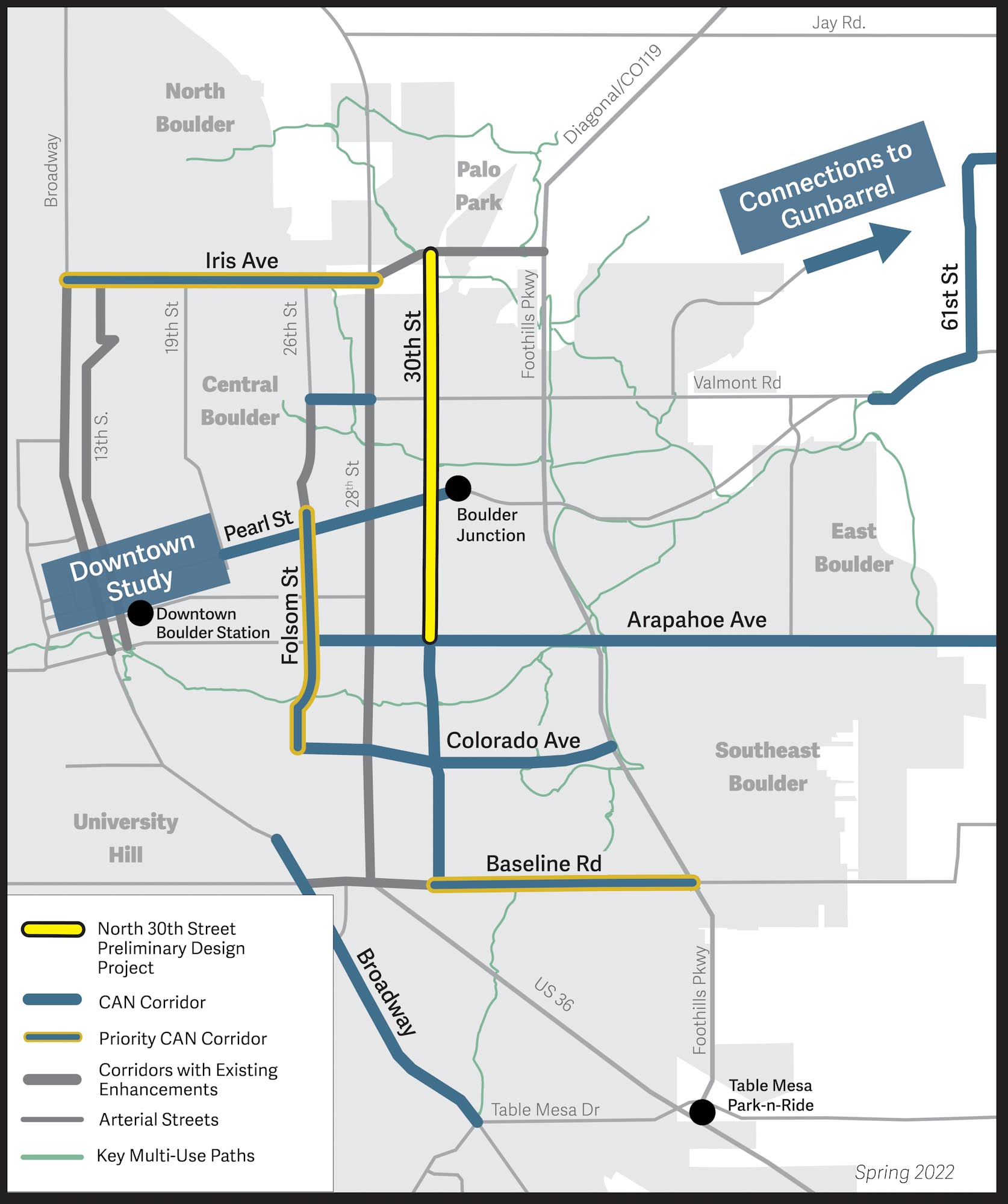
30th Street is a north-south arterial street that provides important connections for multimodal travel — walking, biking, taking the bus and driving.
Today, conflicts between different ways of travel are causing delays for buses and serious safety hazards for people walking, biking and driving on north 30th Street.
By redesigning the street to balance the needs of all travelers, we can create a safer, more efficient street, ensuring smoother commutes for everyone.
This project collaborated with the diverse community members living, working, and traveling on 30th Street to inform a preliminary design that makes 30th Street between Arapahoe Avenue (CO 7) and Diagonal Highway (CO 119) safer and more connected for all travelers.
Community Engagement
Virtual Open House
Learn more about the approved design at the last virtual open house.
Descripción general y aspectos destacados del diseño aprobado
North 30th Street Preliminary Design Project Approved Design Overview & Highlights Spanish video
1 of 1
North 30th Street Preliminary Design Project Approved Design Overview & Highlights Spanish video
1 of 1
Past Engagement
Thank you to everyone who participated in the engagement activities we hosted in 2024 and 2025! We met with community members at events around Boulder, held pop-ups at local businesses, and had neighborhood discussions to capture everyone's vision for an improved north 30th Street. Participants shared a variety of feedback. For additional details on who we spoke to and what the project accomplished, view materials below.
2024
Past engagement events include tabling and pop-ups at On the Rise Concert Series in Boulder Junction, at Las 10 Americas Carniceria, the Hispanic Heritage Month 5k at Fleet Feet Boulder, and Columbine Elementary’s Walk and Roll to School Day, Columbine Elementary School Fall Carnival, Community Bike Ride with Full Cycle Bikes, transit stops on the corridor, the Goose Creek multi-use path, and Brookdale North Boulder. In November, there were also engagement events specific to the Boulder Housing Partners, Bluebird Apartments, Boulder Junction, Orchard Grove, and San Juan Del Centro communities. An English and Spanish questionnaire was also open from Sept. 7 to Nov. 25, 2024.
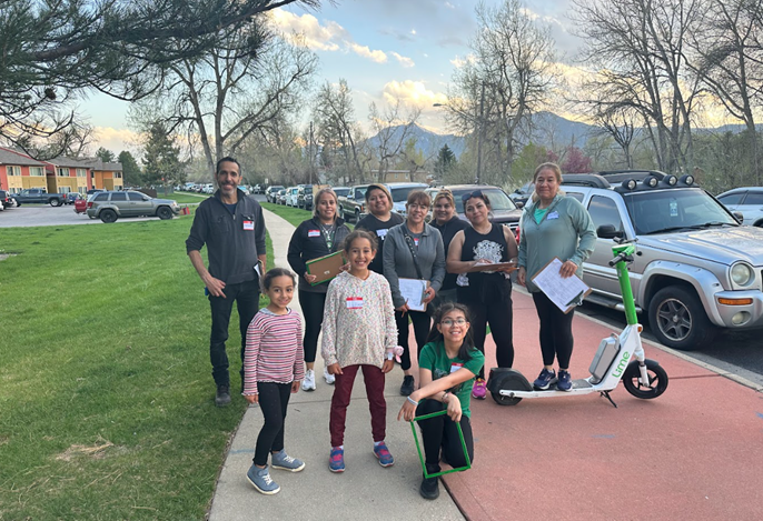
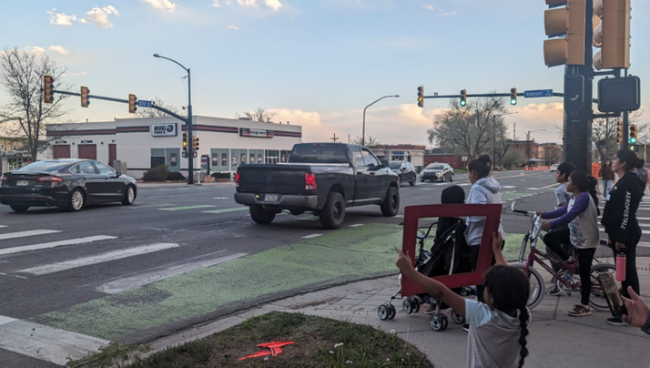
On Wednesday, April 24, 2024, Growing Up Boulder led a walk audit with 11 children and 23 caregivers of the 30th Street and Valmont intersection. Participants used green and red frames to highlight locations and transportation experiences they liked and didn't like.
Youth using red frames to show what they thought could be improved on 30th Street at the April 2024 walk audit.
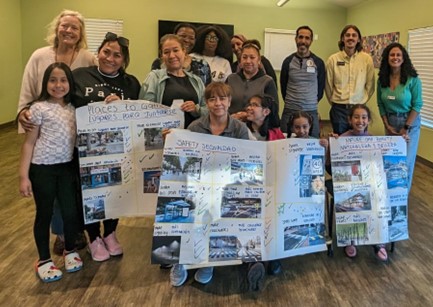
On Wednesday, May 8, 2024, Growing Up Boulder hosted a follow up event with seven children and seven caregivers to review the findings from the walk audit. Participants shared additional thoughts through a visual preference questionnaire.
Participants at a May 8, 2024, follow-up event with results of visual preference questionnaire.
Over the week of Jan. 13-16, the project team presented what we heard from the Boulder community in 2024 and invited attendees to provide input to help develop conceptual design alternatives for north 30th Street. The week culminated in an open house event on Jan. 16, 2025, where the project team presented the results of the workshop week, the conceptual alternatives and the criteria for evaluating each option. The event included a project kickoff and two open design studios for the community to join the project team as they sketched and built out ideas for design options.There was also a virtual open house from Feb. 10-24 with the same information. Community members joined virtually to learn about completed work focused on community conversations and data collection, and to view and share feedback about the conceptual design alternatives and draft project-specific evaluation criteria, which the project team used to help evaluate and select a recommended alternative in the next phase of the project.
Spring/Summer 2024 to Spring 2025: Community engagement and preliminary design. Community engagement activities kicks off in October 2024. The first phase of community engagement concludes, and the preliminary design phase begins.
Summer 2025: City evaluates preliminary design alternatives for review by the Transportation Advisory Board and City Council.
We document preliminary design alternatives through the city’s Community and Environmental Assessment Process (CEAP). The CEAP is a formal review process to consider the impacts of public development projects, including transportation improvements, to inform the selection and refinement of a recommended alternative.
The recommended project alternative is presented to and reviewed by the city’s Transportation Advisory Board (TAB). The TAB makes a recommendation to City Council, who makes a decision on the project.
Future: City advances design and begins building improvements.
We received a Safe Streets for All (SS4A) federal grant in 2023 to advance design and implement improvements on 30th Street between Pearl Street and the Diagonal Highway. Additional funds will be needed for the remaining recommendations from this preliminary design project, and these will be implemented as funding becomes available.
Frequently Asked Questions (FAQs)
30th Street is an important north-south connection within the city. It’s a vital route for people walking, biking, scooting, using a mobility device, riding public transit, and driving.
The corridor connects to key local and regional destinations such as Boulder Junction, the University of Colorado-Boulder (CU Boulder) East Campus, the 29th Street Mall, market rate and affordable housing for families and students, and small and large businesses. It’s also part of the Core Arterial Network (CAN), which aims to make traveling on Boulder’s main corridors safer, more comfortable, and more convenient no matter how you choose to travel. This project extends on 30th Street from Arapahoe Avenue (CO 7) to Diagonal Highway (CO 119).
On a typical day, 30th Street sees:
20,000 vehicles.
1,109 transit rides.
1,700 walk and bike trips.
Currently, the corridor serves a critical number of multimodal trips, but it is also a top crash location in the city and all road users experience severe safety issues.
Our goal is to make the street:
Safer.
More connected.
More comfortable for all.
This project will address safety concerns identified in previous studies to create a safe and comfortable environment for people who live, work and travel along and across the corridor. Key benefits include:
Meeting the city's Transportation Master Plan (TMP) and Low-Stress Walk and Bike Network Plan goals for safer, reliable, and equitable transportation choices, and improved walking and biking options on 30th Street.
Meeting the goals of the High-Risk Network (HRN) to evaluate the risk factors for crashes on the corridor through data collection, analysis, community engagement to inform conceptual designs that respond to identified safety issues.
Implementing the city's Vision Zero Action Plan (VZAP) to address crash patterns with the goal of eliminating serious injury and fatal crashes within the city.
Reducing potential severe crashes by expanding the city's Core Arterial Network (CAN) and implementing the VZAP to protect bicycle lanes, add intersection enhancements, improve pedestrian facilities, and conduct transit facility upgrades.
Providing more opportunities to travel without a car to reduce emissions from personal vehicles. This change supports the city’s climate action efforts to:
Reduce emissions 70% by 2030 (against a 2018 baseline).
Become a net-zero city by 2035.
Become a carbon-positive city by 2040.
Update the corridor’s design to meet increased road use.
Several factors contribute to the need for improvements:
Safety Concerns: The city's Vision Zero Action Plan (VZAP) identifies 30th Street as part of the High-Risk Network (HRN) with five or more risk factors for crashes. Common incidents include:
Rear-end crashes
Broadside crashes (a car turning in front of another car)
Sideswipe crashes (two cars, side-by-side hitting each other)
People's Experiences: The city’s Vision Zero Action Plan (VZAP) results also found that:
55% of cyclists felt unsafe on the corridor
27% of pedestrians felt unsafe
Regional Recognition: The Denver Regional Council of Governments (DRCOG) recognizes 30th Street as having one of the Denver region’s highest densities of fatal and serious injury crashes.
Previous Community Plans: Several previous plans that include community engagement have called for improvements. Plans advocate for greater separation and protection between vehicles and on-street bicycle lanes on 30th Street as well as improvements in pedestrian improvement areas.
The project consists of two main community engagement phases:
Listening Phase: present existing conditions and reconfirm community priorities from previous plans through a questionnaire, community events, focus group discussions with underrepresented groups, and a citywide virtual and in-person open house.
Design and Discovery Phase: preliminary conceptual designs and recommendations will be presented for public feedback through presentations to underrepresented groups, community events, and a citywide virtual and in-person open house. Community feedback will inform design concepts to improve the corridor, including short- and long-term corridor improvements. Final recommendations and the project’s Community and Environmental Assessment Process will be presented to the city’s Transportation Advisory Board (TAB) and City Council, where members of the public have an opportunity to provide additional comments.
Both community engagement phases include perspectives and preferences of underrepresented communities, ensuring multiple opportunities for community members to learn more about the project, share their experiences, and contribute to final design recommendations.
This preliminary design phase is funded with city transportation funds and a Transportation Improvement Program (TIP) grant, in partnership with the Denver Regional Council of Governments (DRCOG).
A Federal Safe Streets and Roads for All (SS4A) grant will be used to fund final design work. The implementation of project recommendations between Pearl Street and the Diagonal Highway will also be funded through these grants. Improvements not funded with SS4A will be implemented as additional funding becomes available.
Background and Plans Guiding This Project
This street is one of the most diverse in Boulder in terms of land uses and demographics. 30th Street provides local and regional connections to the University of Colorado-Boulder (CU) East Campus and the 29th Street Mall, and higher-density housing (both market rate and affordable) in Boulder Junction, several Boulder Housing Partners (BHP) developments, Orchard Grove, and San Juan Del Centro.
Within a ¼ mile of the corridor, 38% of the population identifies as non-white, compared to 24% in the city (2020 Census), and American Community Survey Data suggests a greater proportion of households near the corridor are low-income and without access to a motor vehicle than the city as a whole.
It is this concentration of people and places that leads to 30th Street seeing 20,000 vehicles, 1,109 transit, and 1,700 walk and bike trips on a typical day — a critical number of walking, biking, bus and vehicle trips.
30th Street is an important north-south arterial street in the city’s Core Arterial Network (CAN) — Boulder’s connected system of multimodal transportation improvements along the city’s main corridors that will help reduce the potential for severe crashes and make it more comfortable and convenient for people to get where they need to go.
The Low Stress Walk and Bike Network Plan calls for greater separation and protection between vehicle lanes and people biking on 30th Street due to the posted speed limit of 35mph, existing vehicle volumes being greater than 6,000, and the role 30th Street plays as a central and direct route in the city’s bike network.
Once improvements to enhance the bike facility on 30th St are implemented, 30th Street will be designated as a Recommended Crosstown Route. Recommended Crosstown Routes are highlighted on the city's bike map and form the north-south and east-west connections of the low-stress bike network using on- and off-street bike facilities. They connect neighborhood centers, schools, parks, university campuses, and job centers in the city, and can help travelers plan direct and comfortable walking and biking routes across Boulder.
Based on the density of destinations near residential land uses, the Low-Stress Plan also identified Pedestrian Improvement Areas on and near 30th Street between Arapahoe Avenue and Walnut Street, and from Glenwood Drive to Diagonal Highway. These areas were identified for improvements such as new sidewalks, ADA upgrades, new pedestrian crossings, or enhancements to existing crossings. With small changes to make the walking environment safer and more pleasant, more people would likely choose to walk to these destinations instead of drive, supporting travel choices in the city.
The Safe Streets Report provides an overview of the City of Boulder's efforts to continuously improve transportation safety by measuring traffic crash data and identifying trends in crashes. The 2022 report showed that 67% of traffic crashes resulting in serious injury or fatality occur on these streets, leading to the CAN initiative.
The 2023-2027 Vision Zero Action Plan (VZAP) is a companion to the Safe Streets Report, and identifies additional strategies the city can take to reduce fatal and severe crashes.
Community engagement for the city’s VZAP found that 55% of people reporting travel safety concerns for 30th Street felt unsafe biking, while 27% felt unsafe walking.
The VZAP identified a High-Risk Network (HRN): streets in the city with five or more risk factors for crashes and identified corridor-wide themes and crash patterns. 30th Street south of Valmont Road is on the HRN. Initial work has been done to identify and address the crash patterns on 30th Street, such as adjusting left-turn signal phasing at high-crash intersections. This 30th Street project will identify additional work to address the risk factors and common crash patterns.
Boulder's transportation vision is to create a safe, accessible and sustainable multimodal transportation system that connects people with each other and where they want to go. Its goal is to be safe, be equitable, be reliable, provide travel choices and support clean air and our climate commitment.
30th Street is designated as a priority bicycle route and high-frequency transit service corridor, which provides transit service every 15 minutes, in the city’s Transportation Master Plan.