This project will improve travel for everyone on the 28th Street and Colorado Avenue intersection and along parts of Colorado Avenue.

  1. Community Engagement

  2. Plan

  3. Build

  4. Complete

Project Overview

This project implemented multimodal safety improvements identified in the 30th and Colorado Corridors Study, including Boulder’s second fully protected intersection, bus lanes, and sidewalk-level bike lanes on parts of Colorado Avenue that will connect to other study projects, including the city’s first protected intersection and other improvements at 30th Street and Colorado Avenue.

A 28th and Colorado project concept graphic illustrating improvements. Long description under design long description header on project page.

View full image

Project Improvements

The project reconstructed the intersection to improve it with:

  • A protected intersection, which physically separates people walking, biking, and rolling from vehicles up to and through the intersection. Protected intersections also make it easier for these travelers to see and be seen by drivers.
  • New, sidewalk-level protected bike lanes eastbound and westbound along Colorado Avenue.
  • New bus lanes and transit stop improvements along parts of Colorado Avenue. Bus lanes are dedicated to transit vehicles to help increase reliability, but can also be used by right-turning vehicles, for access to businesses. The bus lanes are marked in red, making it easier for all travelers to see where to go. Just like green bike markings, these colors are part of federal guidance to help people travel safely.
  • Other improvements including ADA improvements, sidewalk improvements, conflict zone pavement marking, and traffic signal improvements.

Protected Intersections 101

Learn what a protected intersection is and how to use it in this short video. This video was created for Boulder’s first protected intersection at 30th Street and Colorado Avenue and also applies to the 28th Street and Colorado Avenue protected intersection.

Video in English

Video in Spanish

What is a protected intersection and how do I travel through it?

Through their design, protected intersections physically separate people walking, biking, and rolling from vehicles up to and through the intersection and make it easier for these travelers to see and be seen by drivers.

Protected intersections include:

  • Corner islands that extend the protected bike lane to the intersection.
  • Increased space between the vehicle lane and bike lane that creates more visibility for people walking, biking, and rolling.
  • A dedicated path for bikes through the intersection, painted green.

Timeline

Construction is complete. Additional minor work such as landscaping and wayfinding signage, will be finalized in the coming months.

Construction began in November 2023 and was completed in June 2024. Work is anticipated to last into mid-2024. This intersection was identified for multimodal safety improvements after an extensive engagement process for the 30th Street and Colorado Avenue Corridors Study. The study began in 2017 and following community engagement was approved by City Council in 2019. View details on the study webpage.

Funding

This project is funded by a combination of city, state and federal funds. This includes funds from the Colorado Department of Transportation Revitalizing Main Street grant program and the federal Congestion Mitigation Air Quality Improvement program.

Project Background

28th Street and Colorado Avenue is a busy intersection where many people travel by walking, biking, rolling, taking the bus and driving. The city’s Safe Streets Report, which evaluates traffic crash data in Boulder, identified this intersection as one of the areas in the city with the highest number of crashes. The city identified this intersection for multimodal safety improvements in partnership with CU Boulder through the 30th Street and Colorado Avenue Corridors Study. The study evaluated existing and future travel conditions and needs to identify transportation projects that will improve travel and safety in the area for everyone.

Improvements are also an important part of the city’s Core Arterial Network (CAN), which includes both 28th Street and Colorado Avenue. The CAN is a connected system of protected bicycle lanes, intersection enhancements, pedestrian facilities, and transit facility upgrades that will help reduce the potential for severe crashes and make it more comfortable and convenient for people to get where they need to go along Boulder’s main corridors.

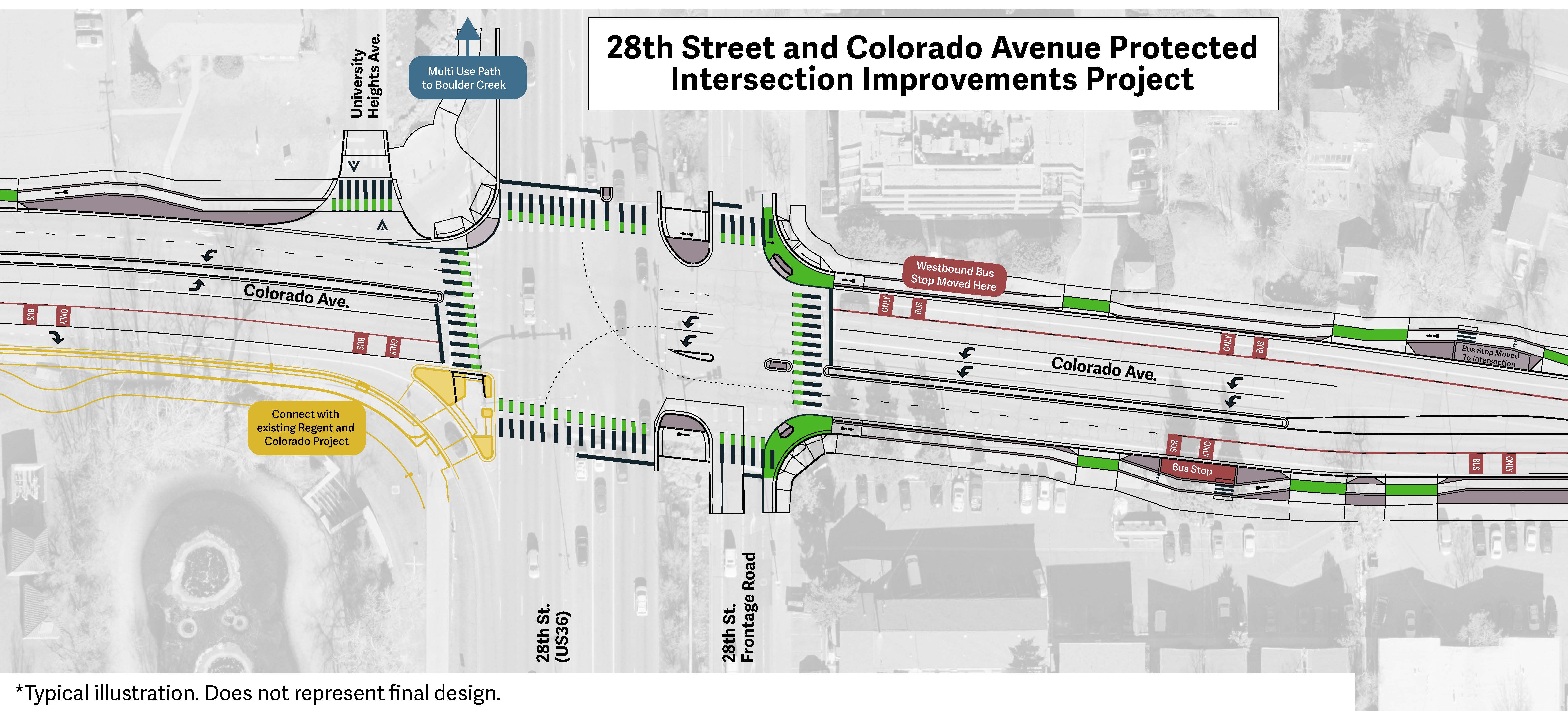
This is a text alternative to the concept graphic. An overhead graphic design of improvements to 28th Street and Colorado Avenue intersection. The westbound bus stop on the north side of the road is moved closer to the intersection. The southwest corner of the intersection connects to the existing Regent Drive and Colorado Avenue project. Image is a typical illustration and does not represent final design. The project's southwest corner connects to the existing Colorado and Regent project, which constructed a partial protected intersection at the corner, where there is a physical barrier between the bike lane and the vehicle turning lane. The northwest corner of the project connects to a Boulder Creek multi-use path. The northeast and southeast corners are newly protected.There are new red bus lanes going east and west.