The Cheyenne and Arapaho Tribes

Contributors

  • Frank Medicine Water, Arapaho
  • Pauline Medicine Water, Arapaho
  • Fred Mosqueda, Arapaho
  • Mary Mosqueda, Arapaho
  • Clarinda Fletcher, Arapaho
  • Chester Whiteman, Cheyenne
  • Roy Dean Bullcoming, Cheyenne

Cheyenne and Arapaho History

Archaeological evidence of human occupation of the Boulder area goes back more than 13,000 years. Arapaho oral traditions reflect a long period of occupation, as evidenced in the following history told by Mr. Fred Mosqueda.

"We have stories from long, long, long, long time ago. We crossed this huge, vast area of ice. When the Arapahos were crossing it, there was a white out. So the old people, they got lost. They didn't know which way to go because of the white out and it was just a vast expansion of ice they were crossing. So seven old men and seven old women sat down and they started praying and then they heard a sound. They looked up, and above them were Sandhill cranes in a circle, making that sound. So [the old men] said “They will know where land is.” So they got up and followed the Sandhill cranes. They're the ones that brought us into this country. They migrate from Alaska all the way to the Gulf of Mexico. So, in one of our ceremonies we holler like that, too. We circle like they do. Some Arapaho men will use the bones out of their wings for whistles."

Historical map showing the Cheyenne and Arapaho Reservation established by the Fort Wise Treaty of 1861. The reservation is highlighted in black in southeastern Colorado, near Bent’s Fort, and is bordered by Big Sandy Creek and the Arkansas River. The map also shows nearby rivers, including the South Platte, North Platte, Republican, Smoky Hill, and Arkansas Rivers, as well as Denver City and surrounding territorial boundaries of the Nebraska and Kansas Territories.
(History Colorado, image by Kevin Cahill)

The gray shaded area indicates the land area reserved for the Cheyenne and Arapaho under the 1851 Treaty of Fort Laramie and managed by the Upper Arkansas Indian Agency. The black shaded area indicates the reduced land area reserved for the Cheyenne and Arapaho ten years later under the Treaty of Fort Wise, supervised by Samuel G.Colley.

The Arapaho and Cheyenne traversed land throughout Colorado historically, but as non-native immigrants encroached, the United States government pushed them out. Mr. Frank Medicine Water describes the South Platte Trail, going from Denver to Colorado Springs, as an old Arapaho trail. This trail alone is nearly 100 miles long, showcasing a small section of the huge swaths of land the Cheyenne and Arapaho occupied. Once the Front Range became more populated by non-native people, the Cheyenne and Arapaho groups that were in the north Front Range were forced to draw rations from Fort Laramie, Wyoming. The government agents pushed the rest of the Cheyenne and Arapaho south, to draw rations at Bent’s Fort. This artificially separated the groups into Northern and Southern bands of Cheyenne and Arapaho. Today there is the Northern Cheyenne Tribe and the Northern Arapaho Tribes (the groups who drew rations from Fort Laramie); and the Cheyenne and Arapaho Tribes (who drew rations from Bent’s Fort). This southern group consisting of both Cheyenne and Arapaho signed the 1851 Fort Laramie Treaty (Horse Creek Treaty) together, establishing them as one group in the eyes of the United States government. Due to their closeness of the Tribes, the Southern bands were settled together in Oklahoma. Fred Mosqueda, and Arapaho member of the Cheyenne and Arapaho Tribes explains:

“The Cheyenne are our allies. We are two different people, two different languages; but due to treaties and the closeness of our Tribes, we got out together. We have more similarities than differences now. We didn't camp together until the 1930s.”
- Mr. Fred Mosqueda

Fred Mosqueda is interviewed by Jessica Yaquinto, who writes in a notebook with her back to the camera. Mosqueda stands beyond her, speaking while looking into the distance, with an out‑of‑focus green field behind them.

Mr. Fred Mosqueda talks with ethnographer Jessica Yaquinto

The Fort Laramie Treaty took place in Fort Laramie, Wyoming, but this location is just one place in the expanse of lands the Cheyenne and Arapaho historically traversed, with the help of the horse.

“We covered all the way from Colorado Springs up to north of Fort Collins in the wintertime. In the summertime all the bands would be moving out. You have to think about, well, how come they couldn't all stay together all the time? Well, we went to Fort Laramie in 1851 when they signed the treaty, they had to move the treaty signing because they didn't have enough grass at Fort Laramie for all the horses. I think they figured that the tribe when they showed up; had in excess of 50,000 horses themselves. So that is a bunch of grass that is needed to keep those horses.”
-Mr. Frank Medicine Water

Portrait of married couple Frank and Pauline Medicine Water standing side by side with arms around each other, smiling before an out‑of‑focus forested background.

Mr. Frank Medicine Water and Mrs. Pauline Medicine Water in Boulder

Gold was discovered in Denver in 1858, just ten years after the Fort Laramie Treaty. Soon after, in 1861, the Cheyenne and Arapaho were moved to a reservation along the Arkansas River in eastern Colorado with the signing of the Fort Wise Treaty. This treaty drastically reduced the Nations’ land base and the document itself had been altered between the time it was signed and when it arrived in Chicago to be entered into the official record. Despite clear evidence that the treaty had been tampered with, the Cheyenne and Arapaho had no legal recourse to challenge it.

“Once it got to Chicago, the wording and some of the conditions were changed. That made that treaty void, because when you go into a contract-the way we know it-if you change anything after signatures, then it voids out the whole contract.”
-Mr. Chester Whiteman

By the early 1860s, relations between the Tribal Nations and government agents had deteriorated rapidly. An executive order was issued declaring that any “unfriendlies” were to be killed, and the possessions of those killed could be kept as payment by their attackers. This order sanctioned open violence against Indigenous people. Governor John Evans, a railroad entrepreneur whose interests aligned with bankers, industrialists, and railroad developers, knew exactly where the Cheyenne and Arapaho camped at Sand Creek. That camp was not a hostile encampment, it was more like a retirement village, home to elders, women, and children, along with a few horses. It was a peaceful place. Evans took advantage of that peace, as many of the Cheyenne warriors were north and east of Sand Creek, in the Smoky Hill region near the Big Timbers area, along the river. On October 10, 1864, Company D of the Colorado Militia attacked a small Cheyenne camp at Buffalo Springs near Sterling, Colorado and this was the first blood drawn by the militia. There were at most four warriors present; the rest were women and children. The militia killed the women as they bathed their babies, killing the mothers and infants alike. This foreshadowed the horror to come.

Just weeks later, on November 29, 1864, the Colorado Cavalry launched a brutal attack at Sand Creek, murdering approximately 230 peaceful Cheyenne and Arapaho people. Evans and others stood to profit from the removal of the Cheyenne and Arapaho, as they were “in the way” of westward expansion and industrial projects tied to railroads and land speculation. The Sand Creek Massacre was not a battle, it was a slaughter carried out against a peaceful people. The warriors returned and saw what had happened. Soon after, the Cheyenne passed the war pipe to the Lakota, and then carried it to Cherry Creek, where it was smoked with the Arapaho, signifying the renewal of alliance and collective resistance.

“We want that blood that was spilled to be recognized, for our kids, our grandkids, our great grandkids to know their history and where they came from. We weren't the aggressors. Our people are compassionate people.”
-Mr. Fred Mosqueda

Following Sand Creek, the surviving Cheyenne and Arapaho faced yet another forced removal. In 1867, just three years later, the Medicine Lodge Treaty was signed, moving the southern communities of the Cheyenne and Arapaho to Indian Territory, in present-day Oklahoma. Although the Kiowa, Comanche, and Apache signed separate treaties at Medicine Lodge, the southern Cheyenne and Arapaho were the direct victims of Sand Creek and the signatories to their own treaty. Some have mistakenly assumed that these treaties came with reparations, but there were none. The southern Cheyenne and Arapaho, who signed the Medicine Lodge Treaty, paid the price for Sand Creek, and carried the memory of those lost into their new homelands.

“When they moved us down into Oklahoma, we wanted to stay at Fort Supply because it's a straight shot west to the Panhandle. And that was the last place to hunt buffalo”
-Mr. Frank Medicine Water

It is impossible to overstate the importance of the buffalo to the Cheyenne and Arapaho people.

“They [the buffalo] did everything for the Cheyenne. They supplied shelter, food… Everything in the buffalo was used by the Cheyennes in everything they did. They didn't waste nothing. I don't know how they [the Cheyenne] really survived by handout after the soldiers came in and the soldiers and took over killing the buffalo. They disappeared quick. But the Cheyenne used to honor, respect the animal, but that was lost way back. I don't know what year that would be but, that put the Cheyennes in a real bad situation, when the buffalo started disappearing. And they [the soldiers] did it just for sport, not for survival. And that was the lifeline for the Cheyenne.”
-Mr. Chester Whiteman

Calling the buffalo the ‘grocery store’ of the Cheyenne people, Mr. Chester Whiteman explained that, besides eating buffalo meat, the Cheyenne people used the hoofs to make glue, the marrow for food, the bladder for water, and the hide could be used to make drums.

Candid portrait of Chester Whiteman seated at a wooden picnic table, speaking and pointing behind the photographer, with a wooded background out of focus.

Mr. Chester Whiteman speaks with City of Boulder staff

The Cheyenne and Arapaho in the Boulder Area

As previously stated, the Cheyenne and Arapaho people moved through the Boulder Valley at various times. The Arapaho word for the Boulder area would be Boulder: Heet3iixoobee' (Where it gets steep) or Heet3iiookuu (Where it goes up). Mr. Whiteman explained that the Cheyenne people had a main winter camp just north of Sand Creek, and they would pass through the Boulder Valley on their way to and from there. The Cheyenne and Arapaho presence in the Boulder area has given rise to some legendary figures. Niowat (pronounced Nawath), whose English name was Chief Lefthand, lends his namesake to many areas in the Boulder Valley. His English name comes from the fact that he was left-handed. This is uncommon for Arapaho people. Some Arapaho elders may even tie a child’s left hand to his side if the child is shown to be favoring it. (Fred Mosqueda, interview, 2023)

“You always drink with your right hand because that's the future. If you drink with your left hand, that means you're going to relive the past and you don't want to do that. So you always want to go forward. I think the sign for the past is to the left.”
-Mr. Fred Mosqueda

Perhaps the most well known story of Niowat tells how he allowed some white settlers to stay in present-day Boulder for a season, and they never left. This has inspired folklore of a ‘Lefthand Curse’, which the Arapaho representatives think is unlikely to ever have occurred.

"I’ve heard people say that Niwot said ‘People, seeing the beauty of the valley, will want to stay. But their staying will be the undoing of the beauty’. This was told to me that this was the curse Chief Niwot said about the Boulder Valley.
I don't think that he would say that. In so many terms, [Lefthand would’ve said] ‘you can't stay here’ because he would understand the 1851 treaty because he could understand English. [...] So he would have said ‘you are on our land that's been given’ and he would have understood that the treaty said that they can pass through, but they can't stay. So that's what he said. ‘You can't stay here, you have to leave’. [...] I think that's just romanticizing the fact that he's here. Tourism is very strong and you always want to add a little more to make the story just a little bit more, you know, keener so that people will come. That's what you're doing.”
-Mr. Fred Mosqueda

Another figure often associated with Niowat is Little Raven, an Arapaho leader who rode with him (Fred Mosqueda, interview, 2023). Mr. Mosqueda explained that Little Raven and Niowat were riding together right before the Sand Creek Massacre, but Little Raven did not stay at Sand Creek as Niowat did. Other notable people who narrowly avoided Sand Creek were Spotted Wolf and his brothers, Yellow Bear and Mountain. Mountain was said to have a wheel and therefore be a spiritual and ceremonial leader.

“Left hand’s band was the only one that moved to Sand Creek. I remember Little Raven took the rest of the Arapaho and moved them east along the Arkansas River at that time, he didn't stay there. Little Raven was you know, of course, he's one of them old men. So they had special abilities. You know, I always say, I listened to my mother and grandma, they could tell the future, you know, they could tell what was gonna come to pass. So that's probably why he moved.”
-Mr. Fred Mosqueda

“There's a story also, Spotted Wolf was here, and his brother, Yellow Bear and his other brother Mountain. They came through Sand Creek that night before, but there was nothing to eat. So they went and they camped on, they were going towards where Little Raven was. So they camped down there and they heard the battle going on in the morning and so they got up there and looked down. And then told Little Raven what happened. So that's how the Arapahos found out about Sand Creek.”
-Mr. Fred Mosqueda

A large rocky outcrop in Boulder OSMP rises behind a flat green field with scattered conifers.

Spring foliage in Boulder

There are a few details concerning Niwot that the representatives dispelled, the first being the images of Niwot that are often cited, are not actually of Niwot. Niwot was sick and never made it to Oklahoma.

“There are two Lefthands. The older one (Niwot), and one that was born in the Oklahoma panhandle and took over as principal chief after Little Raven died. He is buried in Oklahoma with Jesse Chisholm. He was a young man when Sand Creek took place. It is said that he rode with the older Lefthand before Sand Creek up to Fort Lyons. The Lefthand that was in Colorado; there aren't any photos of him. Only the younger one in Oklahoma.”
-Mr. Fred Mosqueda

Additionally, Mr. Frank Medicine Water explained that Niwot is often mis-characterized as violent but was actually an advocate for peace. He explains there are many stories of him seeking a peaceful resolution to the conflicts with non-native settlers. Even when he was ill and could not travel, he was sending his brothers and nephews to meetings to broker peace (Frank Medicine Water, interview, 2023). Another peaceful figure in Arapaho history is Niwot’s sister, Snake Woman. She married a French man named John Poisel, and she was sometimes called Ma-Hom, which may have been a pet name given to her by her husband. Their oldest daughter was called Margaret Poisel and she married Thomas Fitzpatrick. Fitzpatrick was the first Indian agent for Cheyenne and Arapaho Tribes. He was called ‘broken-hand’ because his hand had been mangled in an accident.

“Snake woman was, to me, she was very important and her children continued on but she was almost invisible. That's the way a lot of Arapaho women are. They're invisible, but they're the strength behind the men because we can't make decisions without them. But she was married to a white man and this white man taught her and her brothers how to speak English. So when the settlers started to come into this area, he (Niwot) was able to talk to them, so he was an interpreter for Little Raven. Little Raven trusted Left Hand and used him until his death. After he passed away, they used Snake Woman's daughters [...] Snake Woman had a daughter named Margaret Fitzpatrick and she was the interpreter at Fort Laramie. She was married to a Fitzpatrick, but he moved her and her children up to St Louis. So then her sister Mary was the interpreter at Medicine Lodge.”

Side view of Mr. Chester Whiteman and Mr. Roy Dean Bullcoming being interviewed by Joanie Finch, who holds a recorder while speaking with Mr. Whiteman seated on a boulder.

Mr. Chester Whiteman and Mr. Roy Dean Bullcoming talk with LHA ethnographer Joanie Finch

Family played a central role in the lives and leadership of the Cheyenne and Arapaho people, grounding their communities through times of peace and hardship alike. For figures such as Niwot and his sister Snake Woman, family was not only a bond of kinship but also a means of cultural survival and continuity. The oral histories shared by Representatives reveal that decisions of diplomacy, migration, and even conflict were rarely made by individuals alone, but through the counsel and support of family members. Snake Woman’s work as an interpreter, and later that of her daughters, demonstrates how familial lines carried forward both language and responsibility across generations. These ties ensured that even as external pressures came in, the strength of family preserved the values, knowledge, and unity of the Arapaho and Cheyenne peoples.

Animals in the Boulder Area

While visiting the Boulder area, Cheyenne and Arapaho Representatives saw many animals. For examples, eagles were spotted nesting in a park west of the City. “Its a refuge for eagles and a place they [the public] can watch them, but don't interfere with them” advised Mr. Fred Mosqueda.

Visiting another city park, Tribal Representatives saw a large group of crows that landed in the surrounding trees and started cawing.

“Crows, houu [ho] in Arapaho, can travel from heaven and back to here. He [the crow] is the one that used to bring messages from heaven. He is a symbol of the ghost dance. Also the magpie. ”
-Mr. Fred Mosqueda

The conversation then turned to another type of bird, the meadowlark. It is said that meadowlarks speak Arapaho. If one noticed a child having a hard time speaking, they would be fed a meadowlark, and then the child would learn to speak Arapaho. Fred Mosqueda is one of the last speakers of his dialect of Arapaho, as the children who attend language school learn Northern Arapaho. Mr. Frank Medicine Water shared that men and women traditionally speak slightly different forms of the Arapaho language. Mr. Fred Mosqueda shared more about how he learned Arapaho:

“We [the Arapaho] came down to Cantonment, and that's where the Mennonites had started a church there and they started the school. The government would say, [to the missionaries] “Well, if you're gonna be there, then you take care of the schools, too.” So they opened up schools and they went to the sixth grade there or something like that. And when my grandmother went to school there for sixth grade, she could sign her name, she could read a little bit, she still spoke real broken English. She didn't use proper pronunciation. She could in Arapaho but not in English. So, but that's where I grew up.”
“There were always songs, they were always singing every morning, you'd hear my uncle sing songs and then my grandmother would sing, my mother would sing. And so as we just grew up with songs from the ceremony songs, Sun Dance song, Ghost Dance song, all these songs she would sing. And then when we started growing up, well, then we started to sing. So my grandmother passed away and then my mother started, you know, teaching us all these songs and how to sing them”
-Mr. Fred Mosqueda

Seeing a spider, Fred Mosqueda shared the Arapaho name for spider as nih'oo3oo [nehahthaw], who is a trickster figure in Arapaho mythology. A nod to Arapaho history, this is also the word for white man. Caterpillar is neyooxet [neeyak-hcach] and is also related to Arapaho history.

“It's neyooxet [neeyak-hcach] the same thing we call Whirlwind Woman or Tornado. She's a very powerful figure in our what you guys would call mythology, in our creation story. When the world was created, it was small. Then Whirlwind Woman began to blow and she began to move and she blew and she traveled clear around the earth. And by the time she got back, it was the size that it is today. So she's the one that created the size of the earth.”
-Mr. Fred Mosqueda

With the streams running through the Boulder Valley, modern people may assume fish would have been a staple food, but the Cheyenne and Arapaho representatives want to correct that misconception.

“No, no, no. We didn't eat fish.”
-Mr. Fred Mosqueda

Meat was dried for the winter as well, and people followed game trails up into the mountains in the past to hunt for elk and deer. The Boulder area would have provided so much for people, with its abundant plant life, water sources, and game.

Elevation

The high elevation of Boulder and its surrounding mountains provided unique resources and opportunities for people before colonization. Mountain peaks may have been used for gathering specific medicines, following game trails, eagle catching, ceremony, and scouting other Tribes out on the landscape. Representatives agreed that the elevation was high enough that people would have only come up here for specific reasons.

“If they came this high, there was a purpose. There was a reason why to come this high. They had to be tough. [...] Even a horse coming up here would be tough.”
-Mr. Frank Medicine Water

“When they were up here, it wouldn't be a Tribe as a whole moving along. It was probably individual camps to come up, maybe gather medicines and plants and different things like that up in this higher elevation.”
-Mr. Chester Whiteman

Mr. Frank and Mrs. Pauline Medicine Water stand with ethnographer Reshawn Edison on large rocks overlooking distant mountains.

Mr. Frank Medicine Water and Mrs. Pauline Medicine Water observe views of the Boulder Valley with LHA ethnographer Reshawn Edison

There are some plants that only grow in higher elevations, so a person would need to travel up to harvest them. The representatives explained that Cheyenne and Arapaho people only took what they needed, and taught others about medicinal plants through practice.

“I gather a little bit. As time goes along, I’ll have enough to make that. I have all the ingredients to make that medicine. And that's when I call folks together. If you want to learn how to make this: come over.”
-Mr. Chester Whiteman

Along with large game, eagles were valuable animals that could be interacted with at high elevations. Offerings need to be made before, during, and after during an eagle hunt for the spirit of the eagles. Elder men and their younger helpers would construct a blind that looked like a shelf on the side of the mountain, and then use willows and other tree branches for cover so the eagle couldn't see the people. Sometimes, it would take days to catch an eagle. The elder men used specific medicines to try to catch them. Once caught, they had several uses, but they were first and foremost a sacred animal.

“You would use the head and the claws, the tail feathers, the plumes. When they got done with using all that, they always buried the remains. The bones, [...] whistles are made out of the bone.”
“They were the messengers from our father. They're the ones that, you see the Arapahos using eagles all the time because, you know, them four old men*? They could come to you in the form of an eagle. They come and take care of you, watch you.”
-Mr. Fred Mosqueda

[*When Our Father created the first Arapaho, he put four Old Men or Grandpas (could be understood as similar to angels) in the four directions, not the cardinal directions but the Southeast, Southwest, Northwest and Northeast. They are like our guardian angels. Their sign to us is the Morning Star.]

Along with eagle traps, elder men may have used the seclusion of higher elevations to perform fasting rituals. The old men built a little fasting shelter for the person who was fasting. Fasting is an important part of the spiritual life of Arapaho men. There would be many reasons for fasting but it was typically to ‘find out what you need to know’.

“Everything the Arapahos do, everything we have, comes from someone going out and fasting and praying for it.”
-Mr. Fred Mosqueda

The views from the high vantage points around Boulder reminded Mr. Fred Mosqueda of an Arapaho story. The story describes a great flood (not unlike the great flood of other world religions). The Arapaho people went up onto a mountain and used their moccasins to push the water back down and escape the flood. Arapaho people would have traditionally went into the mountains to gain access to water sources if needed.

High elevation viewpoints would have also been good observation points for both spiritual and strategic purposes. Lookouts facing east make good vantage points to see the morning star.

“The Arapaho’s day starts with the morning star ,which is a messenger for the Arapaho, letting them know that they are being watched over.”
-Mr. Fred Mosqueda

Candid portrait of Mr. Fred Mosqueda with his wife, Mrs. Mary Mosqueda, and daughter Clarinda Fletcher seated on a bench in a wooded area.

Mr. Fred Mosqueda, Mrs. Mary Mosqueda, and Ms. Clarinda Fletcher enjoy the vistas of Boulder, Colorado

Plants

There were several useful plants observed in Boulder. Mr. Fred Mosqueda shared that Douglas Fir is aromatic when it releases its pollen, and adding it to medicine makes the medicine sweet. Ponderosa Pines have pine gum, which also smells very sweet. Bear root (osha) is often called black medicine, and can be prepared and chewed. It numbs the mouth and can be made into a tea to treat respiratory symptoms. Mr. Chester Whiteman shared that male sage, also called prairie sage (artemesia ludoviciana), was also observed, along with food plants like wild currants. Representatives shared that foods like wild turnips, chokecherries, and buffalo berries were likely found in the area in the past, and can be dried for the winter.

More examples include sage, peppermint, bear root, and cottonwood trees. In line with traditional ecological knowledge, Cheyenne and Arapaho people only took what plants they needed, just for themselves, always mindful not to take too much.

Landscape

The notable rock formations in the Boulder area would have been used for navigation purposes, and held spiritual importance. “The mountains had unlimited power and it's still here” says Mr. Fred Mosqueda. “I can trace my bloodline to here [...] I know that people who were related to me walked here and walked this ground and now I’m walking on it again”. When discussing the overall management of the Open Space and Mountain Parks lands around Boulder, the Representatives prioritize the natural state of things:

“I think people should be allowed to walk and enjoy the outdoors. You can live in a city and it becomes, I don't know, kind of like a rat race. But, when you come to a place like this, it's quiet and you can hear nature and then you can recharge in a place like this. You're probably doing therapy to a lot of people just by allowing them to come through here and, and to be in different areas.”
“This probably was a happy place at one time because it provided so much and they stayed here. But they weren't allowed to stay. But now, we come back and we can walk this ground and look at it and see it and be welcomed here. You know that's a little different than the way they were. After gold was found, they were no longer welcome here. This place took care of them. If you tell the story from before, it was a happy place, a good place.”
-Mr. Fred Mosqueda

The wooded areas on the outskirts of the City would have been good for gathering teepee poles, which the horses would’ve helped to transport and maneuver. When discussing how Buckingham Park fits into the larger Cheyenne and Arapaho landscape, the Representatives explained that all of the places in the area are related through Chief Lefthand. To keep everyone fed and not deplete resources, the Arapaho needed to break up into bands. Spotted Wolf, Yellow Bear, Niwot (Lefthand), and Little Raven, would have camped at different locations.

“We were so completely removed from this place- we can’t say they are important because of the removal. But there are places here that are important to our people or important things happened here” Mr. Frank MedicineWater explained. “I don’t think there is any place that we can walk that they didn’t walk before us” shared Mr. Fred Mosqueda.

Speaking more about the camp structure, representatives shared that huge camps and ceremonies could have happened at places in Boulder that are now developed, so it's impossible to tell what could have been there. The structure and layout of a typical Arapaho camp would have depended on its purpose. Smaller camps would have held family bands, and others could be upwards of 70 lodges. At 3-5 people per lodge, the larger camps could have held about 350 people. The council of seven old men and seven old ladies, whose duty was to advise and bless the people, would have been located in the back of a large camp.

The representatives stated that the water makes it a great place to camp, not only because the people and horses could drink water, but the water also draws in larger game. “We only traveled between water sources, and that’s how we traveled. A horse can go 15 miles on one tank of water. We would camp along the water, according to water” explained Mr. Frank Medicine Water.

Mr. Fred Mosqueda added,“Water is where it starts. There is a spirit that takes care of that water source, before you use or cross that water you should give an offering/prayer to the water. Nothing can live without water, [...] Water is life, its life giving”.

Mr. Roy Dean Bullcoming stands on a rocky outcrop beside a fast‑moving stream, with forested banks and a blue sky with large white clouds.

Mr. Roy Dean Bullcoming observing a Boulder Valley stream

Final Thoughts

Reflecting on the trip to Boulder as a whole, the representative shared these comments:

“We were here as a people, we survived in Boulder, and all along the front range. We were strong people who are not as we are portrayed in the history. We lived here through circumstances that we couldn't help, we were moved from this area. There are no Indians living east of the Rockies of Colorado. We survived. We got pushed all the way to Oklahoma which was a dumping ground for Indians. We are still there. We live there. We are offered this chance to come here back home and I think it's important that we come talk to y’all and get to be here on this ground again. We still live with the same traditions and customs that we had here and we still use them and live by them.”
-Mr. Frank Medicine Water

“We're out of balance. When this earth is out of balance, we're out of balance. So it's not one tribe or anybody. It's everybody. Everybody has to get back on the right page. And then folks are gonna have to give up this money, this greed. That's a big problem and they're going to have to learn how to pray and respect one another.”
-Mr. Chester Whiteman

David Ford and Fred Mosqueda stand with their backs to the camera at a Boulder OSMP overlook, partly hidden by a large boulder, as David points toward distant green and snow‑capped mountains beneath a clear blue sky.

Mr. Fred Mosqueda viewing mountains with City staff member David Ford

Bibliography

Anderson, Jeffrey. 2001. The Four Hills of Life: Northern Arapaho Knowledge and Life Movement. Lincoln: University of Nebraska Press.

Berthrong, Donald J. 1963. The Southern Cheyennes. Norman: University of Oklahoma Press.

Blythe, Jeffrey W. 2005. Ethnohistoric Investigation and Report of Consultation to Identify Resources of Native American Cultural and Religious Significance on Pueblo Chemical Depot, Pueblo County, Colorado. Report prepared for Pueblo Chemical Depot. Loveland, TX: Gene Stout and Associates.

Blythe, Jeffrey W. 2007. Report of Tribal Consultation October 2006–May 2007: Traditional Cultural Properties/Sacred Sites Inventory and NAGPRA Compliance Report, Schriever Air Force Base, Colorado. Report prepared by Blythe and Trousil, Inc. for Versar, Inc., under contract to the Air Force Center for Engineering and the Environment.

Blythe, Jeffrey W. 2008a. Ethnohistoric Context Native American Consultation (Phase II), Cheyenne Mountain Air Force Station, Colorado. Milwaukee: TN & Associates, Inc.

Blythe, Jeffrey W. 2008b. Our Footprints Are There: Report of Native American Consultation to Identify Traditional Cultural Properties and Sacred Sites on Lands Administered by Fort Carson, Colorado. Report prepared for Fort Carson. Loveland, TX: Gene Stout and Associates.

Blythe, Jeffrey W. 2008c. Report of Tribal Consultation August 2007–October 2008, Schriever Air Force Base, Colorado. Report prepared by Blythe and Trousil, Inc. for Versar, Inc., for the Air Force Center for Engineering and the Environment.

Brett, John A. 2003. Ethnographic Assessment and Documentation of Rocky Mountain National Park. Denver: Department of Anthropology, University of Colorado at Denver.

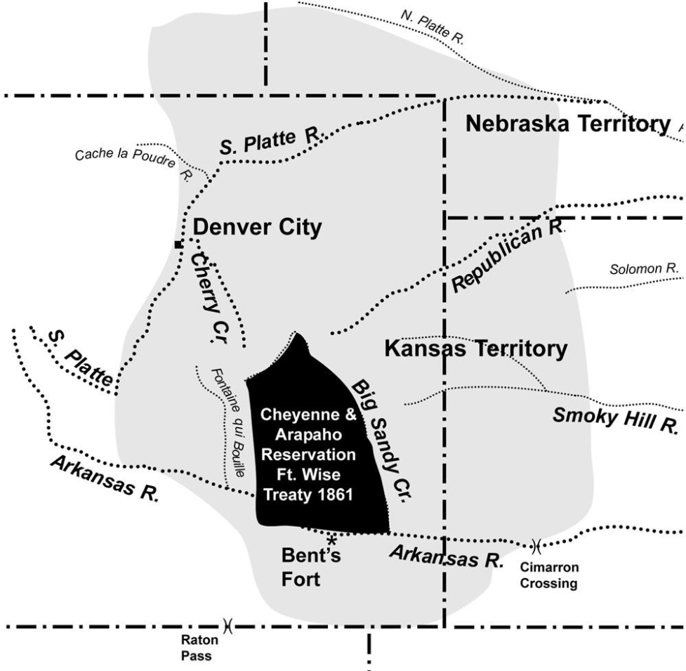
Campbell, Gregory R. 2007. An Ethnological and Ethnohistorical Assessment of Ethnobotanical and Cultural Resources at the Sand Creek National Historic Site and Bent’s Old Fort National Historic Site. Vols. 1–2. Missoula: University of Montana.

Campbell, Gregory R. n.d. Documenting and Inventorying Ethnographic Resources at Yellowstone National Park. Report prepared for the National Park Service. Missoula: University of Montana.

Cowell, Andrew. 2004. “Arapaho Place Names in Colorado: Indigenous Mapping, White Remaking.” Names 52: 21–41.

Cowell, Andrew. 2018. Naming the World: Language and Power among the Northern Arapaho. Tucson: University of Arizona Press.

Cowell, Andrew, with Alonzo Moss Sr. 2003. “Arapaho Place Names in Colorado: Form, Function, Language, and Culture.” Anthropological Linguistics 45: 349–89.

Cowell, Andrew, with Alonzo Moss Sr. 2004. Plants and Plant Names in Arapaho Life and Language. Boulder: Center for the Study of Indigenous Languages, Department of Linguistics, University of Colorado.

Cowell, Andrew. 2008. The Arapaho Language. Boulder: University Press of Colorado.

Cowell, Andrew, and Alonzo Moss Sr., eds. 2005. Hinóno’éínoo3ítoon: Arapaho Historical Traditions Told by Paul Moss. Winnipeg: University of Manitoba Press.

Cowell, Andrew, William C’Hair, and Alonzo Moss Sr., eds. 2014. Arapaho Stories, Songs, and Prayers: A Bilingual Anthology. Norman: University of Oklahoma Press.

Elkin, Henry. 1940. “The Northern Arapaho of Wyoming.” In Acculturation in Seven Indian Tribes, edited by Ralph Linton, 207–55. New York: Appleton-Century.

Grinnell, George Bird. 1923. The Cheyenne Indians: Their History and Ways of Life. Vol. 1. Lincoln: University of Nebraska Press. Reprint, 1972.

Gunnerson, James H., and Dolores A. Gunnerson. 1988. Ethnohistory of the High Plains. Cultural Resource Series no. 26. Denver: Bureau of Land Management, Colorado State Office.

Hanson, Jeffrey R., and Sally Chirinos. 1997. Ethnographic Overview and Assessment of Devils Tower National Monument. Denver: U.S. Department of the Interior, National Park Service.

Hoebel, E. Adamson. 1960. The Cheyennes: Indians of the Great Plains. New York: Holt, Rinehart and Winston.

Howbert, Irving. 1970. The Indians of the Pike’s Peak Region. Glorieta, NM: Rio Grande Press.

Jones, Donald G., Martha Williams, Kathy Stemmler, Michael Ho McGrath, and Elizabeth C. Winstead. 1998. Ethnohistoric and Ethnographic Information Related to the Fort Carson Military Reservation and Piñon Canyon Maneuver Site in Colorado. Frederick, MD: R. Christopher Goodwin & Associates, Inc.

Kelley, Shawn, and Sean O’Meara. 2016. Capulin Volcano National Monument: Ethnographic Overview and Assessment. Prepared for the National Park Service. Albuquerque, NM: Parametrix.

Kelley, Shawn, Sean O’Meara, Damon Hill, and Karen Koestner. 2017. USAFA Ethnographic and Ethnobotanical Survey. Vols. 1–3. Albuquerque, NM: Parametrix.

Kelley, Shawn, Sean O’Meara, Damon Hill, and Marilyn Martorano. 2019. Traditional Use Study for Great Sand Dunes National Park and Preserve. Albuquerque, NM: Parametrix.

Kroeber, Alfred L. 1983. The Arapaho. Lincoln and London: University of Nebraska Press.

Kroeber, Alfred L., and George Dorsey. 1997. Traditions of the Arapaho. Lincoln: University of Nebraska Press.

Marquis, Thomas B. 1978. The Cheyennes of Montana. Algonac, MI: Reference Publications, Inc.

McBeth, Sally. 2007. Native American Oral History and Cultural Interpretation in Rocky Mountain National Park. Prepared for the National Park Service. Greeley, CO: University of Northern Colorado.

Mooney, James. 1907. “The Cheyenne Indians.” Memoirs of the American Anthropological Association 1 (6): 357–442. Reprint, 1976.

Moore, John H. 1974. “Cheyenne Political History, 1820–1894.” Ethnohistory 21 (4): 329–59.

Moore, John H. 1996. The Cheyenne. Cambridge: Blackwell Publishers.

Moss Sr., Alonzo, and Andrew Cowell. 2012. Arapaho Place Names. Boulder: Center for the Study of Indigenous Languages of the West, University of Colorado.

Murphy, James. 1969. “The Place of the Northern Arapahos in the Relations between the United States and the Indians of the Plains, 1851–1879.” Annals of Wyoming 41: 33–61, 203–59.

O’Meara, Sean. 2022. Indigenous Connections: Native American Ethnographic Study of Golden, Colorado, and the Clear Creek Valley. Tucson, AZ: Anthropological Research.

O’Neil, Brian, Cheryl A. Harrison, and Michael Berry. 2017. An Archaeological Assessment of the Gunsight Pass Site (5GA4251): Archaeoastronomy and Landscape Archaeology in Middle Park, Grand County, Colorado. Grand Junction, CO: Domínguez Archaeological Research Group, Inc.

Phillips, Scott C., Thomas A. Witt, and Holly K. Norton. 2013. Ethnographic Context for the Ross In-Situ Recovery Project Area, Crook County, Wyoming. Broomfield, CO: SWCA Environmental Consultants.

Powell, Peter J. 1981. People of the Sacred Mountain: A History of the Northern Cheyenne Chiefs and Warrior Societies, 1830–1879. San Francisco: Harper & Row.

Salzmann, Zdenek. n.d. Arapaho Indian Research Papers. American Heritage Center, Accession no. 10396. University of Wyoming, Laramie.

Salzmann, Zdenek. 1980. Arapaho Stories. Anchorage, AK: National Bilingual Materials Development Center.

Salzmann, Zdenek. 1983. Analytical Bibliography of Sources Concerning the Arapaho Indians. Ethete, WY: Wind River Reservation.

Salzmann, Zdenek. 1988. The Arapaho Indians: A Research Guide and Bibliography. New York: Greenwood Press.

Scott, Hugh Lennox. 1907. “The Early History and the Names of the Arapaho.” American Anthropologist 9: 545–60.

Steeves, Paulette F. C. 2023. The Indigenous Paleolithic of the Western Hemisphere. Lincoln: University of Nebraska Press.

Stoffle, Richard W., Henry F. Dobyns, Michael J. Evans, and Omer C. Stewart. 1984. Toyavita Piavʉhʉrʉ Koroin: Ethnohistory and Native American Religious Concerns for the Fort Carson– Piñon Canyon Maneuver Area. Kenosha, WI: University of Wisconsin–Parkside.

Svingen, O. J. 1993. The Northern Cheyenne Indian Reservation, 1877–1900. Niwot, CO: University Press of Colorado.

Toll, Oliver W. 2003. Arapaho Names and Trails: A Report of a 1914 Pack Trip. Boulder, CO: Rocky Mountain Nature Association. Originally published 1962.

Trenholm, Virginia Cole. 1970. Arapahoes, Our People. Norman: University of Oklahoma Press.

Watts, Linda K. 2005. Native American Cultural Resources in the Pike and San Isabel National Forests and Comanche and Cimarron National Grasslands: Site Features Present and Recommendations Concerning Protection and Preservation. Prepared for the National Park Service and U.S. Forest Service.

Weist, Thomas. 1984. A History of the Cheyenne People. Billings: Montana Council for Indian Education.

Ethnographic Education Report Navigation

Explore the other reports linked below.

Lakota

The City of Boulder Ethnographic Education Report: Lakota: The Oglala Sioux Tribe and The Rosebud Sioux Tribe

Pawnee Nation

The City of Boulder Ethnographic Education Report: Pawnee Nation

Ethnographic Education Report Introduction