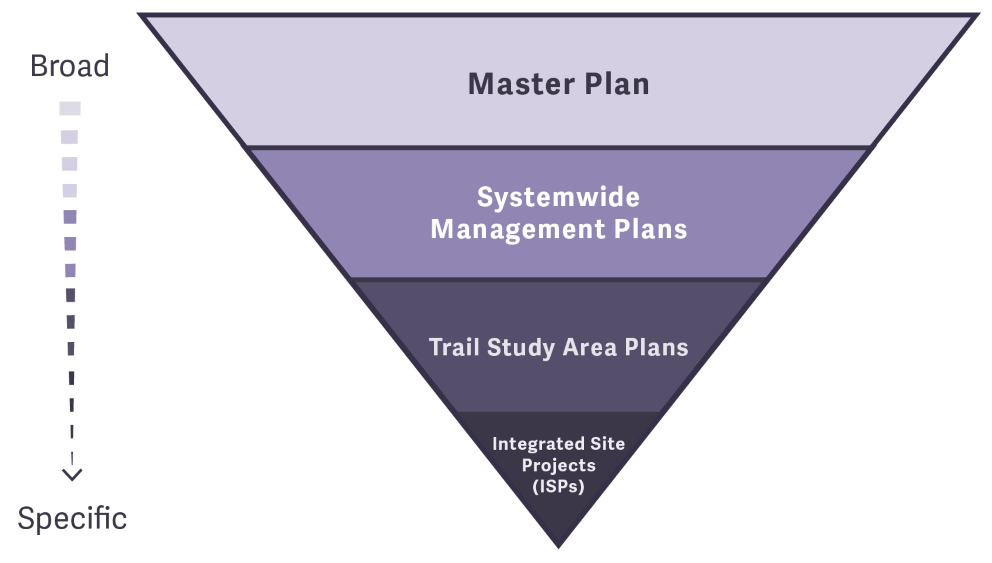
Open Space and Mountain Parks (OSMP's) plans range from providing broad, strategic and overarching guidance to site-specific guidance. Broad plans inform site-specific plans and they are all used to guide the delivery of OSMP’s services to the Boulder community. In addition to OSMP’s plans, the management of the department is also guided by integrated citywide policy, including but not limited to: the City of Boulder Charter, Sustainability Framework, Climate Commitment, Resilience Strategy, Racial Equity Plan, and Boulder Valley Comprehensive Plan.
OSMP's Plan Types
Master Plan (2019)
The Master Plan focuses OSMP’s energy, funding and expertise on a clear vision for the next decade and beyond. It describes our five focus areas- or central management themes- which are: Ecosystem Health and Resilience; Agriculture Today and Tomorrow; Responsible Recreation, Stewardship and Enjoyment; Community Connection, Education, and Inclusion; and Financial Sustainability. It articulates our aspirations and our collective hopes as desired outcomes for the future of OSMP- with broad management strategies to achieve them as well as examples of actions that will fulfill Master Plan guidance. It also sets manageable expectations about what can be achieved given our uncertain financial future.
Master Plan Implementation - Annual Reports
Systemwide Management Plans
Agricultural Resources Management Plan (2017)
The purpose of the plan is to maintain and enhance agricultural-related values for the community by ensuring the long-term sustainability of agricultural operations, by taking a conservation approach that supports the ecological health of OSMP lands, and by fostering key connections between the community and its agricultural lands.
Forest Ecosystem Management Plan (1999)
The Forest Ecosystem Management Plan addresses the need for ecosystem management on open space lands.
Grassland Ecosystem Management Plan (2010)
The Grassland Ecosystem Management Plan (Grassland Plan) proposes specific on-the-ground management actions, public policies and lands & water acquisition priorities to conserve the ecological values of Open Space & Mountain Park's grasslands and ensure on-going agricultural production.
Visitor Master Plan (VMP) (2005)
The VMP’s purpose is to provide a framework for decisions that will ensure a continued high quality visitor experience, while at the same time ensuring that the lands are protected and preserved for future generations.
Trail Study Area (TSA) Plans
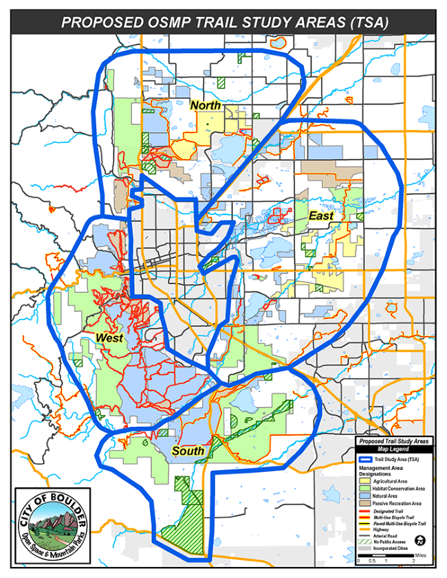
TSA plans were identified in the Visitor Master Plan (VMP) as area-specific plans to establish implementation strategies that improve visitor experience and provide a sustainable trail system while protecting natural and cultural resources. The number and extent of TSAs was modified from what was envisioned in the VMP after completion of the Eldorado Mountain/Doudy Draw TSA.
Completed TSA Plans and Inventory Reports
- Marshall Mesa/Southern Grasslands TSA Plan PDF (2005)
- Marshall Mesa/Southern Grasslands TSA Inventory Report PDF (2005)
- Eldorado Mountain/Doudy Draw TSA Plan PDF (2006)
- Eldorado Mountain/Doudy Draw TSA Inventory Report PDF (2006)
- West TSA Plan PDF (2011)
- West TSA Inventory Report PDF (2009)
- North TSA Plan PDF (2016)
- North TSA Inventory Report PDF (2015)
Area Management Plans
Integrated Site Projects (ISPs)
OSMP is currently developing Integrated Site Projects (ISPs) for several specific locations. ISPs strive to:
- Implement previously-approved plans on-the-ground;
- Sustain natural areas;
- Improve visitor experiences;
- Improve operations, services, and programs in the area; and
- Address other open space values as outlined in the Boulder City Charter.
The goal is to holistically plan for and to have clarity and as much as possible alignment across the community about the “on the ground” actions for an area in order to proceed to the implementation phase. These projects are guided by specific open space purposes in Section 176 of the city charter, which specifically lists OSMP’s responsibilities to the land and to the community. Previously approved land management plans and the project area’s resources – such as natural, agricultural, passive recreation, cultural and scenic resources - and ongoing service needs – such as Ranger patrols, maintenance operations and education and outreach - also help shape the on-the-ground actions.
Implementation work is ongoing for the ISPs below.
The Gebhard Integrated Site Project seeks to provide access to the South Boulder Creek corridor while protecting rare and federally threatened wildlife and plant species in an area east of the East Boulder Community Center. More information is on the Gebhard ISP project page.
The Wonderland Lake ISP area includes the Wonderland Lake Loop Trail (on OSMP lands) and area that encircles Wonderland Lake, and the Wonderland Lake Trailhead, with associated Foothills Nature Center.
The City of Boulder’s Open Space Board of Trustees have recommended that Open Space and Mountain Parks (OSMP) advance the preferred package of actions into detailed design and execution over the coming years. An overview of the phased approach to implementation is below:
Wonderland Lake ISP Action | Next | Mid-Term | Long-Term |
---|---|---|---|
Prohibit boats and belly boats | X | ||
Allow ice skating at own risk | X | ||
Sledding remains prohibited | X | ||
Name change | X | ||
Lake fish and amphibian habitat | X | X | X |
Renovate F.N.C. | X | X | |
Public restrooms | X | X | |
Regulatory closure | X | X | |
Restore peninsula habitat | X | ||
Restore shoreline peninsula habitat and visitor waterfront experience | X | ||
Add interpretive signage | X | ||
Update regulatory signs | X | ||
Add temporary peninsula restoration education signage | X | ||
Bring trails up to accessibility standards | X | X | |
Learning laboratory | X | X | |
Replace kiosk and signs | X | ||
Minor parking lot reconfiguration | X | ||
Update trailhead bike racks | X | ||
Small group gathering area | X | ||
Designate and construct 1-2 fishing rocky steps | X | ||
Extend fencing along spillway | X | ||
Southwestern access point relocation or add vehicle turnaround | X | ||
Designate northwest and southeast access points | X | ||
Bring existing northeast Utica access point up to standards | X |
More detailed information on the proposed actions is available in the October Board Memo PDF and presentation PDF.
The city manager, upon the board recommendation, also approved a community proposal to change the name of the entire Wonderland Lake area to Wonderland Lake Wildlife Sanctuary.
View the Final Site Management Plan PDF for the Gunbarrel Hill ISP.
Policy Guidance
Research Findings and Reports
- 2010-2011 Visitor Survey Report PDF
- 2011 Voice and Sight Tag Program Monitoring Report PDF
- 2011/2012 System-Wide Undesignated Trail Inventory Monitoring Protocol PDF
- 2011/2012 System-Wide Undesignated Trail Inventory Monitoring Report PDF
- 2015 Chautauqua Study Area Visitation Monitoring Report PDF
- 2015 Voice and Sight Monitoring Report PDF
- 2016 Resident Survey Report PDF
- 2016 Voice and Sight Tag Program and Leash Regulations Monitoring PDF
- 2016-2017 OSMP Visitation Estimate Report PDF
- 2016-2017 Visitation Estimate Data Explorer
- 2016-2017 OSMP Visitor Survey Report PDF
- 2018 Undesignated Trails and Roads Survey PDF
- 2018 Undesignated Trail Program Overview PDF
- 2018 Undesignated Trails and Roads Story Map
- 2014-2018 Voice and Sight Tag Monitoring
- Visitation Data Explorer
- 2019-2020 Parking Study Report PDF
- 2019 OSMP Master Plan Survey - updated Jan. 2020 PDF
- 2021 Parking Study: Parking Behaviors at Select Sites Report PDF
- 2019-2023 Designated Trail Condition Monitoring Report PDF
- 2019-2023 Undesignated Trail Monitoring Report PDF
- 2021-2023 Public Opinion and Visitor Experience Survey
Independent Research Reports
OSMP staff have worked with independent researchers to conduct extensive studies to help manage and improve Boulder's open space.