Project Overview
The city's Design and Construction Standards (DCS) and Boulder Revised Code (BRC) include standards governing how transportation infrastructure must be designed and constructed in the public right-of-way.
The city's Design and Construction Standards (DCS) and Boulder Revised Code (BRC) include standards governing how transportation infrastructure must be designed and constructed in the public right-of-way.
The city is currently updating these standards to better align with current best practices and the city’s vision for a multimodal, connected transportation system, according to the city's Transportation Master Plan and Low-Stress Walk and Bike Network Plan.
City Council approved the proposed updates to the DCS and BRC sections below:
City Council also directed staff to update DCS Section 2.03Q to include standards for Vision Zero as part of the traffic crash analysis subsection.
City Council considered approval of these changes in a two-meeting process:
The proposed changes were presented to the Transportation Advisory Board (TAB) and the Planning Board for their review, public hearings and recommendation to City Council.
Both boards made unanimous recommendations to City Council to approve the proposed changes. A summary of the update process and the recommended changes can be found in the TAB meeting memo.
Community engagement in early 2022 included targeted outreach to the public as well as groups that regularly use the DCS and have expressed an interest in the update. This includes the development and engineering community, Community Cycles Advocacy Committee (CCAC), Colorado Department of Transportation (CDOT), Regional Transportation District (RTD), and Transportation Advisory Board (TAB). Project Staff held three separate virtual office hours and presented to CCAC and to the Center for People with Disabilities.
Over a hundred comments on individual elements of the update were received from community members, stakeholders, and advocacy groups. These comments helped the project team clarify terminology and ensured the update was more consistent and precise. Generally, the feedback received was supportive of the proposed changes related to narrower lane widths, minimizing the number of left-turn lanes, and minimizing corner radii. The team was reminded to consider transit needs, build facilities that can be maintained, and focus on pedestrians and people with disabilities. The team also heard several items that were outside the scope of this update but could be included in future phases.
Below are key comments and themes from the input received:
Below are key comments and themes from the input received to date by category:
| Topic | Feedback Summary |
|---|---|
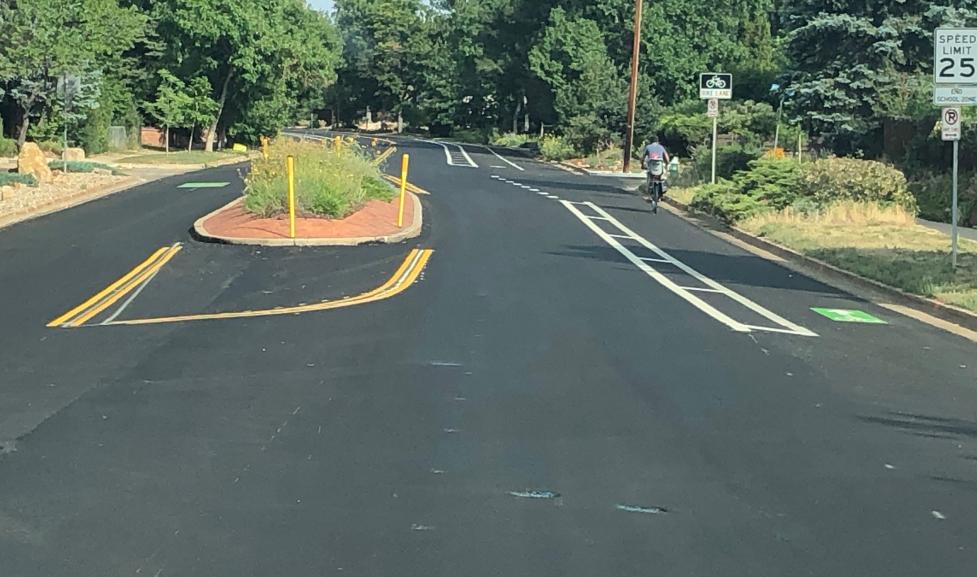
| DCS Chapter 2.07 Street Geometric Design | Generally, staff were asked to consider weather conditions and to make sure transit vehicles were accommodated. There were several items that were brought to staff’s attention that resulted in changes to this section. As suggested by community members, a figure was added to Ch. 2 to describe the features of a Right Turn Raised Crossing. Staff have also updated bus lanes widths from 12' wide to 11' wide based on comments from community members. Concerns about double left-hand turn lanes were also raised. In response, staff added language for Director approval on double lefts. There were also requests for a “maximum” turning radius. Staff determined that creating a blanket "maximum" turning radius would make off-set intersections require additional ROW to construct. However, per Ch. 2 the smallest feasible flowline curb radii should be selected for corner designs. Comments question the need for standard and buffered bike facilities. Bike lane facility types were determined in the City’s Low-Stress Walk and Bike Network Study previously, and changes to these designations are outside the scope of this DCS Update. There are physically constrained streets where there is only space for a conventional bike lane so having a facility in the DCS with parameters for their design and construction will support consistent and more effective outcomes when this facility is developed. |
| DCS Chapter 2.11 and 2.14 Bicycle Facilities, Multi-Use Path Design and (new) Traffic Calming Design | Clarification was provided on the difference between traffic circles and roundabouts, specifically, circles do not move curb ramp locations and benefit pedestrians by providing safer crossings with lower vehicle speeds. The team also added guidance on transit operations around traffic circles. There were questions about shifting lanes and tapers, which are based on a formula from the Manual of Uniform Traffic Control Devices and on the slower operating speed of a bicycle. There were also general concerns about separate bike lanes treatments, intersection treatments, contra-flow lanes, and excessive marking and signing. Some comments, such as those regarding chicanes, truck aprons, and bicycle wayfinding signage, could be included in a future project phase. Other comments, like education, enforcement, and speed setting, are outside the scope of this project. |
| DCS Chapter 3 Streetscape Design and Tree Protection |
Comments received request standards for rain gardens. Requirements for the design and construction of rain gardens and other stormwater facilities are covered in BRC 11-5 and DCS Chapter 7. Comments also encouraged the use of native species in project landscaping, and enabling language has been added to reference resources such as the City’s Revegetation Best Management Practices guidebook, which includes native species. |
| DCS Chapter 10 and 11 - Streetscaping Standards and Technical Drawings | No or minimal comments were received. |
| BCR Chapter 6 - Protection of Trees and Plants | No or minimal comments were received. |
The updates to the transportation design standards are part of a larger, multi-year effort to update the city's Design and Construction Standards (DCS). A first round of community feedback on the draft transportation design standards was collected in fall 2021.
The proposed changes are designed to respond to community feedback and better align with current best practices and the city’s vision for a multimodal, connected transportation system, as reflected in Boulder’s Transportation Master Plan, Low-Stress Walk and Bike Network Plan and Forestry Strategic Plan.
The current DCS was adopted in 1998 and updated in 2000 to prescribe minimum standards to be used in the design and construction of public infrastructure located in public right-of-way and easements in the city of Boulder, as well as private transportation improvements that connect or impact public infrastructure. The DCS is enacted through the BRC and changes are adopted by City Council with recommendations from appropriate boards, such as TAB and Planning Board.