Learn more about each project below:
There are two related projects in the area. These upgrades help mitigate potential future flooding and improve multimodal travel connections
The 19th Street and Fourmile Canyon Creek Underpass project, part of a larger Fourmile Canyon Creek Flood Mitigation project, will build a bicycle and pedestrian underpass and help provide additional flood capacity in the future.
The 19th Street Multimodal Improvements project will help improve travel connections between Norwood and Sumac avenues.
Learn more about each project below:
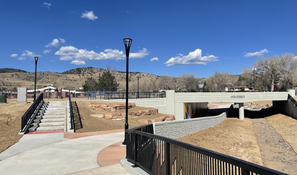
Work is complete on the underpass! Join us to celebrate the project on April 22: Earth Day and Bike to School Day.
The new underpass will allow students, families, and neighbors walking and biking to cross 19th Street completely separate from vehicle traffic to access Crest View Elementary, Crestview Park, and other destinations to the east and west.
New LED lighting has also been installed in the underpass and will stay on 24/7. Landscaping work for the underpass will continue through the spring.

1 of 6

2 of 6

3 of 6

4 of 6

5 of 6

6 of 6
Along with flood mitigation, the 19th Street and Fourmile Canyon Creek Underpass project will improve travel on 19th Street, an important multimodal connection in north Boulder. We constructed a new bicycle and pedestrian underpass connecting Tamarack and Upland avenues; replaced and widened the 19th Street bridge over Fourmile Canyon Creek; improved transit stops; upgraded the on-street bikeable shoulder to a buffered bike lane; constructed a new sidewalk; and installed curb and gutter. Construction began in 2024 and ended in spring 2026.
19th Street from Norwood to Sumac avenues is an important multimodal travel corridor in north Boulder. This project will help improve connections for all travel modes by constructing a new sidewalk and completing missing sidewalk links, upgrading the on-street bike facility to a buffered bike lane, enhancing transit stops, installing curb and gutter, and installing speed cushions, which are similar to speed bumps.
Construction on this project took place from 2024-2026.
From Norwood Avenue to Sumac Avenue on both the east and west sides of 19th Street, the 19th Street Multimodal Project:
From Sumac Avenue to Yarmouth Avenue:
As part of a separate effort, in coordination with city staff, Xcel Energy completed undergrounding of their overhead utilities from Norwood to Upland avenues.
19th Street from Norwood to Sumac avenues is an important multimodal travel corridor in north Boulder. Previously, there was an on-street bikeable shoulder and an existing sidewalk on the east side. These were constructed in the 1990s, but the sidewalk did not meet current city design standards. The on-street bikeable shoulder ended at Violet Avenue and was then a designated bike route from Violet Avenue north to Yarmouth Avenue. On the west side of 19th Street, the sidewalk is not continuous from Yarmouth to Norwood avenues.
19th Street from Norwood to Yarmouth avenues was a high priority on the city's Missing Sidewalk Links program. The Missing Sidewalk Links program identifies, prioritizes and constructs missing sidewalk segments to provide a continuous pedestrian network and ensure a safe walking environment.
In 2014, the city submitted an application for federal funding to construct a 5-foot-wide sidewalk, install curb and gutter on the east side and complete the missing sidewalk links on the west side of this corridor. The project received funding from the Colorado Department of Transportation (CDOT) Transportation Alternatives Program (TAP) and the Federal Highway Administration's Safe Routes to School grant program for the estimated project costs.
We also completed an underpass at 19th Street and Fourmile Canyon Creek, supporting travel and flood mitigation while improving safety and accessibility to Crest View Elementary School. Learn more on the Fourmile Canyon Creek webpage.
We conducted further exploration of the Wonderland Creek floodplain from late fall 2018 through summer 2019 to understand expectations for achieving the floodplain development permit requirements. Two additional alternatives were included in the project's Community and Environmental Assessment Process (CEAP) to meet the identified facility type for 19th Street through the Low-Stress Walk and Bike Network Plan and to address Transportation Advisory Board feedback provided in August 2018. All design alternatives also incorporated the features needed to meet floodplain mitigation requirements.
On Nov. 21, 2019, the project team hosted an open house, with 78 people in attendance, to share the five conceptual design alternatives being considered for the project and asked for the community’s feedback on a preferred alternative and reasons for that preference. There was a comment form available at the open house and online The goal was to learn which option was preferred so we can balance the needs of the community and meet the goals of the Transportation Master Plan. Your input was utilized as a final concept is selected.
Thanks to all who provided their input on the 19th Street Multimodal Improvement Project! We received a total of 58 completed comment forms. Whether you completed it at the open house on November 21, or provided it online, we appreciate your feedback.
Both the meeting comment forms and the online comment forms expressed a preference for Alternative 4 which includes a combination of attached and detached sidewalks and buffered bike lanes.
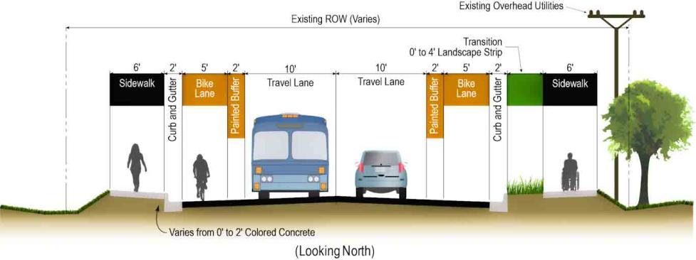
This is a text alternative to the image: typical cross-section of the corridor, facing north. From left to right: 6-foot sidewalk varying from 0-2-foot colored concrete, 2-foot curb and gutter, 5-foot bike lane, 2-foot painted buffer, 10-foot travel lane in one direction, 10-foot travel lane in opposite direction, 2-foot painted buffer, 5-foot bike lane, 2-foot curb and gutter, 0-4-foot landscape strip transition, 6-foot sidewalk next to existing utilities.
During the city's annual capital improvements budgeting process, an interdepartmental team identified the 19th Street project to utilize the city’s Community and Environmental Assessment Process (CEAP). The CEAP is a formal review process to consider the impacts of public development projects. The purpose of the CEAP is to assess potential impacts of conceptual project alternatives in order to inform the selection and refinement of a recommended conceptual design alternative. The CEAP provides the opportunity to balance multiple community goals in the design of a capital project by assessing a project against the policies outlined in the Boulder Valley Comprehensive Plan, the Transportation Master Plan, departmental master plans, and sub-community or area plans (if applicable). The CEAP also ensures that environmental, social and fiscal impacts of projects are minimized and assures compliance with city policies, plans and regulations.
The final CEAP for the 19th Street project was reviewed and provided official recommendation by the City of Boulder CEAP Review Group, the city's Transportation Advisory Board and City Council.


