Biking on Boulder's Extensive Trail System

About 58 miles of trails on Open Space and Mountain Parks are designated for use by bicyclists. Please remember that bikes may only be ridden on trails that are posted with the international bicycle symbol.

E-Bikes on OSMP

City of Boulder Open Space and Mountain Parks (OSMP) recently completed a community engagement process that will allow visitors to ride Class 1 and Class 2 electric bikes on certain open space trails. Read our guide to learn more about the types of e-bikes allowed on Open Space and Mountain Parks trails and where you can ride them. See where e-bike are allowed on Boulder County Parks & Open Space trails.

Remember to recreate responsibly. Whether biking or e-biking, be considerate when passing others on a bike. Slow down and communicate before you pass. While e-bikes are now allowed on specific open space trails, other electric mobility devices – such as e-scooters and e-skateboards – remain prohibited.
Bike Loop Map

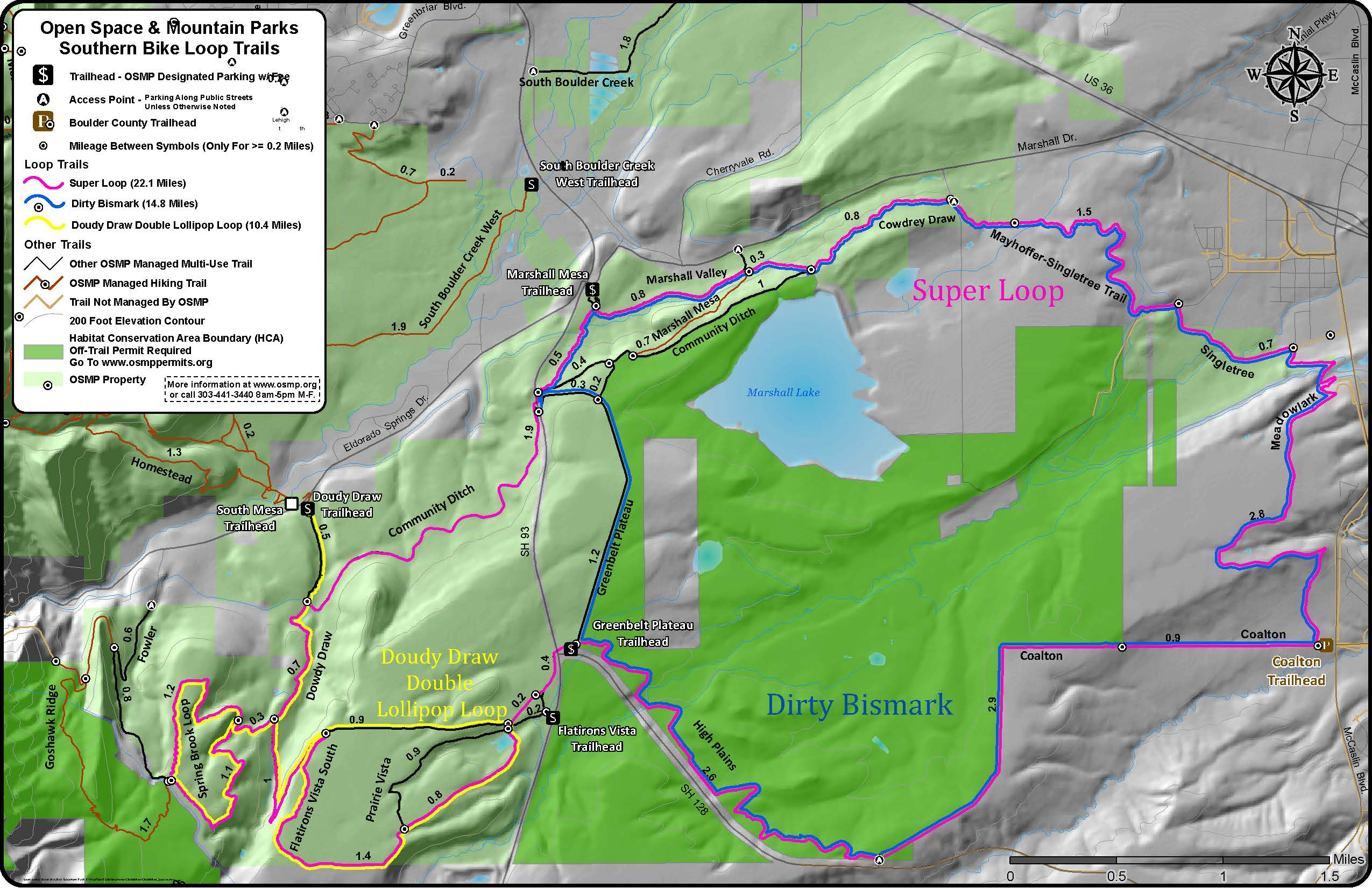
The OSMP Southern Bike Loop Map PDF shows three bike loops in the southern part of the OSMP system. They are called the Super Loop, the Dirty Bismark and the Doudy Draw Double Lollipop Loop, and they range from 10 - 22 miles. While the Doudy Draw Double Lollipop Loop exclusively follows the OSMP trail system, the Super Loop and the Dirty Bismark incorporate both OSMP and Boulder County trails.

Trail Rules & Etiquette

Only ride on trails posted as "bikes allowed"; bikes are not allowed to ride off-trail. Rangers will issue a summons to bikers caught riding off-trail, or on trails where biking is prohibited.

Check osmptrails.org or the Muddy Trail Closures page to see if trails are closed because of muddy conditions.

We all enjoy OSMP in different ways. Expect to encounter other visitors on trails. Be courteous and share the trail so that everyone can have an enjoyable experience. View Trail Etiquette Info from Boulder Mountainbike Alliance and follow the tips below.

When biking on OSMP:

  • Yield the right-of-way to all other trail users and cyclists traveling uphill.
  • Anticipate other trail users around corners and blind spots; be prepared to stop.
  • Pass with care and alert others in advance of your approach.
  • Control your speed at all times. Safe speeds vary with trail conditions and the business of the trail.
  • Practice minimum impact cycling: avoid muddy trails, skidding, hard braking and shortcutting. Riding on wet or muddy trails causes serious trail erosion and may result in a temporary trail closure.
  • Ride only on paved roads and designated bike trails.
  • Don't bring dogs along for the ride.
  • Please check for temporary trail closures before your visit.

Join Boulder Mountain Bike Patrol

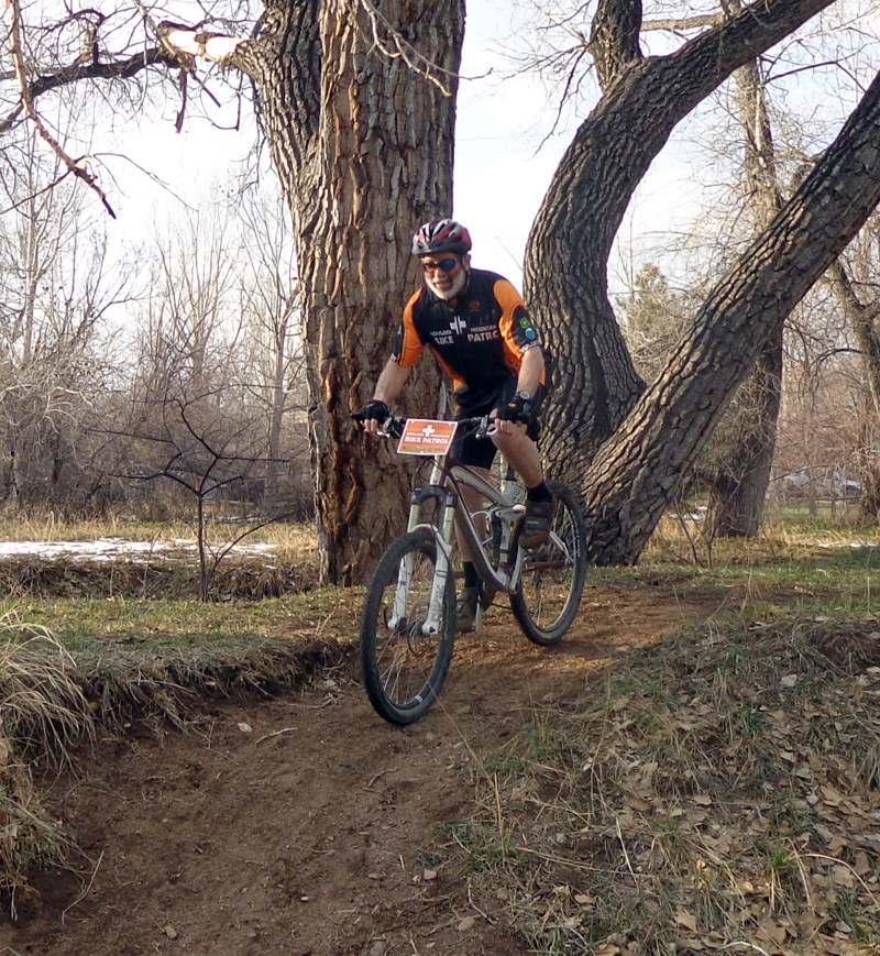
The Boulder Mountain Bike Patrol is a multi-agency program with the City of Boulder Open Space and Mountain Parks (OSMP), Boulder County Parks and Open Space (BCPOS), U.S. Forest Service (USFS), and Boulder Mountain Bike Association (BMA). Patrollers ride trails, assisting and educating mountain bikers and other park users. The goal is to promote a positive recreational experience on the trails.

Boulder Mountain Bike Patroler

OSMP

Trails Open to Bikes

Greenbelt Plateau Trail

Difficulty - easy
Distance - 1.6 miles
Surface - gravel

Greenbelt Plateau travels across a rolling mesa top through open grasslands. Beautiful views of the foothills may be seen to the west as the trail follows the old Highway 93 alignment northward. At 1.3 miles, bicyclists may choose to take the dirt path to Community Ditch Trail or continue on the service road to Highway 93.

Elevation Profile for Marshall Mesa/Greenbelt Plateau Area PDF

High Plains Trail

Difficulty - easy
Distance - 2.5 miles
Surface - gravel / dirt

High Plains trail snakes gently through the sweeping vistas of the Southern Grasslands Habitat Conservation Area, giving a taste of the wide open prairie of pre -settlement days. Because of the area's sensitivity to disturbance and abundant breeding wildlife, off trail travel is only allowed with a permit. Watch for animals as you go: Western Meadowlarks and Vesper Sparrows are common in grassy areas, while you may spy a Northern Oriole or Blue Grosbeak in the shrubs along Coal Creek. With luck, you might glimpse a Bald Eagle or even an elk! The eastern terminus of the High Plains trail connects with the Coalton Trail.

Elevation Profile for Marshall Mesa/Greenbelt Plateau Area PDF

Community Ditch Trail

Difficulty - moderate
Distance - 4 miles
Surface - dirt service road/trail

Community Ditch travels through rolling grasslands and mesas. Evidence of past agricultural practices as well as early coal mining activity can be seen throughout the area. A paved trail accessible to wheelchairs begins at Doudy Draw Trailhead and travels 0.3-mile to a picnic area with restrooms. A dirt path continues on to a junction at Community Ditch bridge. From here, bicyclists may continue east on Community Ditch Trail (a dirt service road that crosses Highway 93 and travels east to Marshall Mesa), or follow Doudy Draw trail to the Flatirons Vista trailhead on Highway 93 (see below).

Elevation Profile for Marshall Mesa Area PDF
Elevation Profile for Doudy Draw/Flatirons Vista Area PDF

Doudy Draw / Flatirons Vista

Difficulty- moderate
Distance- 2.2 miles
Surface- dirt/gravel (0.3 mile paved section at Doudy Draw Trailhead)

Access this trail from either the Doudy Draw Trailhead, or the Flatirons Vista Trailhead. Starting at Doudy Draw, the trail begins on pavement for 0.3 mi, but changes to dirt and connects with Community Ditch (see above). The Spring Brook Loop (see below) can be accessed from Doudy Draw 0.7 mi past the intersection with Community Ditch. The Doudy Draw trail continues up the West side of the creek, crossing it and climbs a steep hill to the top of a mesa with fabulous views of the Front Range. Either Flatirons Vista North or Flatirons Vista South, a loop trail on the mesa, may be traveled to get to the Flatirons Vista Trailhead on Highway 93. A wheel chair accessible trail, Prairie Vista, provides a connection between the two branches of Flatirons Vista Trail. By crossing the highway at the stop light, bikes may access the Greenbelt Plateau and High Plains trails and the Marshall Mesa area. Bicycles may be ridden only on those trails that are posted with the international bicycle symbol.

Elevation Profile for Doudy Draw/Flatirons Vista Area PDF

Spring Brook Loop

Difficulty- moderate
Distance- Spring Brook North 1.2 Miles, Spring Brook South 1.1 Miles
Surface- natural

Access this trail from either the Doudy Draw Trailhead, or the Flatirons Vista Trailhead. Starting from the Doudy Draw trail, the Spring Brook trail heads west for 0.3 mi before splitting into the North and South loops, which are 1.2 and 1.1 mi long, respectively. The Spring Brook Loop Trail passes through habitats of rare and sensitive wildlife species, and forests and grasslands abundant with native plants. Bikes may also take the connection along Fowler Trail to access County Road 67.

Starting from the Flatirons Vista Trailhead, Flatirons Vista North or Flatirons Vista South may be traveled to get to the Doudy Draw trail. The Spring Brook Loop Trail can be accessed by following Doudy Draw 1 mile past the junction with Flatirons Vista. Bikes must remain on trail and may be ridden only on those trails that are posted with the international bike symbol. Bikes are not allowed on Goshawk Ridge Trail.

Elevation Profile for Doudy Draw/Flatirons Vista Area PDF

South Boulder Creek Trail

Difficulty - moderate
Distance - 3 miles
Surface - gravel trail / service road, cement between Bobolink trailhead and East Boulder Community Center

South Boulder Creek Trail meanders near South Boulder Creek, through open pasture from the bridge at the East Boulder Community Center to an underpass at South Boulder Road. Bikes must use the paved path on the section of trail from Baseline Road to the junction with the trail from the East Boulder Community Center. From the South Boulder Road underpass, the trail travels west along South Boulder Road to an entry gate. The trail ends at Marshall Road, just east of Hwy 93. South Boulder Creek and the surrounding area provide important habitat for numerous wildlife species. Dogs are not permitted on the section of trail south of South Boulder Road.

East Boulder Trail

This seven-mile trail has been divided into three sections:

The Teller Farm section follows an easy gravel service road for 2.2 miles of level terrain. Teller Lake is a wildlife preserve and dogs must be leashed within 100 yards of the lake.

The White Rocks section is moderately difficult and follows a combination of dirt trails and service roads for 2.7 miles, the last mile of which climbs a mesa. All travel is restricted to designated trails and dogs are not allowed due to the sensitive nature of the White Rocks Preserve.

The Gunbarrel Farm section begins in the northeast corner of the Heatherwood subdivision and travels along a dirt service road with moderate grades. At 1.2 miles, the trail turns east and enters the White Rocks area. No dogs are allowed in the White Rocks Preserve.

Cottonwood Trail

Difficulty - easy
Distance - 1.2 miles
Surface - gravel

Cottonwood Trail travels between Independence and Jay roads along a tree-lined agricultural ditch. A concrete bike path continues south from the trailhead on Independence Road.

Foothills Trail

Difficulty- moderate
Distance- 3 miles
Surface- dirt/gravel

Foothills South Trail begins at Foothills Nature Center and travels west for 0.2 mile to Wonderland Lake. Cyclists can choose to circle the lake for an easy 1.3 miles or continue north along an improved dirt trail to Lee Hill Road. The trail continues on a gravel service road to the intersection with the Hogback Ridge Trail. Cyclists must continue east on the dirt path to the Foothills Trailhead. This trail is within the city limits of Boulder and dogs must be kept on a hand-held leash at all times.

North Sky and Joder Ranch Trails

Joder Ranch Trail is a 2-mile difficult trail that takes visitors along rolling grasslands into forested foothill communities that stretch across Joder Ranch.

North Sky Trail is a new 3.6 mile difficult trail that connects Foothills North Trail to Joder Ranch. The trail provides visitors with an opportunity to bike all the way from Boulder to Left Hand Canyon.

Boulder Valley Ranch Trails

These trails primarily follow farm access roads through a working ranch.

Eagle Trail is moderately difficult and begins at Eagle Trailhead, traveling west through Boulder Valley Ranch along a gravel service road. At 1.3 miles, the trail climbs a steep dirt path up a mesa and continues another 1.9 miles to Foothills Trailhead.

Sage Trail follows an easy gravel ranch access road for 1.2 miles. This trail connects with Eagle Trail in two locations, making a nice loop through Boulder Valley Ranch.

Cobalt Trail is now open to bikes following a re-route. This .9 mile trail connects with Eagle and Sage Trails and the Boulder Valley Ranch Trailhead.