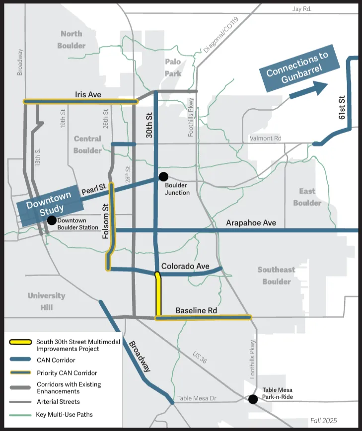
This project will make south 30th Street safer and more connected for everyone traveling, regardless of how they choose to travel.

Paragraph jump menu

Jump To

Project Overview

30th Street is one of the city's main north-south travel corridors for both local and regional travel. The street provides connections to the 29th Street Mall, a considerable share of the city’s retailers, and the three University of Colorado Boulder campuses: Williams Village, Main Campus, and East Campus.

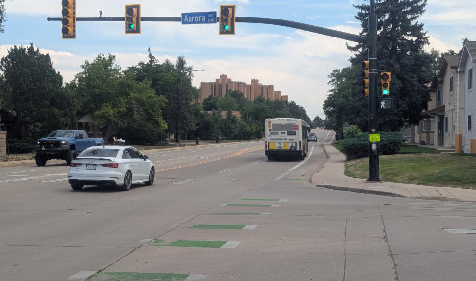
Although it is a main transportation corridor in Boulder, the south segment of 30th Street between Baseline Road and Colorado Avenue lacks the complete street infrastructure to provide safe, convenient and comfortable travel for those walking, biking and taking the bus.

On a typical day, the south segment of 30th Street sees about 13,750 vehicle trips, 164 bike trips, and 198 weekday transit boardings and alightings.

Between 2017 and 2019, the 30th and Colorado Corridors Study engaged the community to identify a preliminary design for 30th Street between Baseline Road and Pearl Street. This project will build on the design and analysis from that study, advance to final design, and construct multimodal improvements on 30th Street between Aurora Avenue and Colorado Avenue. We will implement improvements between Aurora Avenue and Baseline Road when funding is available.

Core Arterial Network map including south 30th Street

Timeline

Anticipated timeline; dates may change.

Background and Plans Guiding this Project

30th Street is an important north-south arterial street in the city’s Core Arterial Network (CAN) — Boulder’s connected system of multimodal transportation improvements along the city’s main corridors that will help reduce the potential for severe crashes and make it more comfortable and convenient for people to get where they need to go.

The Low Stress Walk and Bike Network Plan calls for greater separation and protection between vehicle lanes and people biking on 30th Street due to the posted speed limit of 35mph, existing vehicle volumes being greater than 6,000, and the role 30th Street plays as a central and direct route in the city’s bike network.

Once improvements to enhance the bike facility on 30th St are implemented, 30th Street will be designated as a Recommended Crosstown Route. Recommended Crosstown Routes are highlighted on the city's bike map and form the north-south and east-west connections of the low-stress bike network using on- and off-street bike facilities. They connect neighborhood centers, schools, parks, university campuses, and job centers in the city, and can help travelers plan direct and comfortable walking and biking routes across Boulder.

Based on the density of destinations near residential land uses, the Low-Stress Plan also identified Pedestrian Improvement Areas on and near 30th Street between Arapahoe Avenue and Walnut Street, and from Glenwood Drive to Diagonal Highway. These areas were identified for improvements such as new sidewalks, ADA upgrades, new pedestrian crossings, or enhancements to existing crossings. With small changes to make the walking environment safer and more pleasant, more people would likely choose to walk to these destinations instead of drive, supporting travel choices in the city.

The Safe Streets Report provides an overview of the City of Boulder's efforts to continuously improve transportation safety by measuring traffic crash data and identifying trends in crashes. The 2022 report showed that 67% of traffic crashes resulting in serious injury or fatality occur on these streets, leading to the CAN initiative.

The 2023-2027 Vision Zero Action Plan (VZAP) is a companion to the Safe Streets Report, and identifies additional strategies the city can take to reduce fatal and severe crashes.

Community engagement for the city’s VZAP found that 55% of people reporting travel safety concerns for 30th Street felt unsafe biking, while 27% felt unsafe walking.

The VZAP identified a High-Risk Network (HRN): streets in the city with five or more risk factors for crashes and identified corridor-wide themes and crash patterns. 30th Street south of Valmont Road is on the HRN. Initial work has been done to identify and address the crash patterns on 30th Street, such as adjusting left-turn signal phasing at high-crash intersections. This 30th Street project will identify additional work to address the risk factors and common crash patterns.

Boulder's transportation vision is to create a safe, accessible and sustainable multimodal transportation system that connects people with each other and where they want to go. Its goal is to be safe, be equitable, be reliable, provide travel choices and support clean air and our climate commitment.

30th Street is designated as a priority bicycle route and high-frequency transit service corridor, which provides transit service every 15 minutes, in the city’s Transportation Master Plan.